2024 Weather Thread
-
skinzfan23

- City Council
- Posts: 11628
- Joined: Mon Feb 09, 2004 11:26 am
- Location: Omaha/Bellevue
Re: 2024 Weather Thread
I only got .3", what did everyone else get? I know that there is potentially more rain later today, but I was hoping that we would get close to an inch.
-
Cermak
- Planning Board
- Posts: 2330
- Joined: Thu Nov 29, 2018 1:02 pm
Re: 2024 Weather Thread
I got a 1/4 “, SW Omaha. Grass should start to really grow and thicken up.
Last edited by Cermak on Tue Apr 16, 2024 12:01 pm, edited 1 time in total.
-
BRoss

- IT Director
- Posts: 10003376
- Joined: Fri Aug 04, 2006 7:39 pm
- Location: West Central Omaha
Re: 2024 Weather Thread
.22" here
-
Brad

- Photographer
- Posts: 1036553
- Joined: Sat Feb 28, 2004 6:03 pm
- Location: Omaha, NE
Re: 2024 Weather Thread
I got the same, and was also hoping for at least an inch. But also thankful we didn't get the hail...skinzfan23 wrote: Tue Apr 16, 2024 11:11 am I only got .3", what did everyone else get? I know that there is potentially more rain later today, but I was hoping that we would get close to an inch.

Omaha Skyline Photos, Omaha Aerial Photos, and More.
Website: www.bradwilliamsphotography.com
Facebook: www.facebook.com/bradwilliamsphotography
Twitter: www.twitter.com/bradwphoto
Instagram: www.instagram.com/bradwilliamsphotography
YouTube: www.youtube.com/@bradwilliamsphoto
-
Brad
- Photographer
- Posts: 1036553
- Joined: Sat Feb 28, 2004 6:03 pm
- Location: Omaha, NE
Re: 2024 Weather Thread
There has been a tornado warned storm east of Columbus for quite a while now. However in the past hour, a whole line of storms has fired south of that storm all the way to the Kansas Border. Also an isolated cell popping up on the south side of Lincoln.
Omaha Skyline Photos, Omaha Aerial Photos, and More.
Website: www.bradwilliamsphotography.com
Facebook: www.facebook.com/bradwilliamsphotography
Twitter: www.twitter.com/bradwphoto
Instagram: www.instagram.com/bradwilliamsphotography
YouTube: www.youtube.com/@bradwilliamsphoto
-
skinzfan23
- City Council
- Posts: 11628
- Joined: Mon Feb 09, 2004 11:26 am
- Location: Omaha/Bellevue
Re: 2024 Weather Thread
Tru dat....haha. I was going to go to the office today but decided to work from home b/c of the hail threat.Brad wrote: Tue Apr 16, 2024 12:41 pmI got the same, and was also hoping for at least an inch. But also thankful we didn't get the hail...skinzfan23 wrote: Tue Apr 16, 2024 11:11 am I only got .3", what did everyone else get? I know that there is potentially more rain later today, but I was hoping that we would get close to an inch.
-
Brad
- Photographer
- Posts: 1036553
- Joined: Sat Feb 28, 2004 6:03 pm
- Location: Omaha, NE
Re: 2024 Weather Thread
I thought you got to parking in the parking garage at work?skinzfan23 wrote: Tue Apr 16, 2024 1:39 pm I was going to go to the office today but decided to work from home b/c of the hail threat.
Omaha Skyline Photos, Omaha Aerial Photos, and More.
Website: www.bradwilliamsphotography.com
Facebook: www.facebook.com/bradwilliamsphotography
Twitter: www.twitter.com/bradwphoto
Instagram: www.instagram.com/bradwilliamsphotography
YouTube: www.youtube.com/@bradwilliamsphoto
-
Brad
- Photographer
- Posts: 1036553
- Joined: Sat Feb 28, 2004 6:03 pm
- Location: Omaha, NE
Re: 2024 Weather Thread
LOL, and just like the the lines breaks up so the OMA Dome is in effect again!Brad wrote: Tue Apr 16, 2024 1:32 pm There has been a tornado warned storm east of Columbus for quite a while now. However in the past hour, a whole line of storms has fired south of that storm all the way to the Kansas Border. Also an isolated cell popping up on the south side of Lincoln.
You do not have the required permissions to view the files attached to this post.
Omaha Skyline Photos, Omaha Aerial Photos, and More.
Website: www.bradwilliamsphotography.com
Facebook: www.facebook.com/bradwilliamsphotography
Twitter: www.twitter.com/bradwphoto
Instagram: www.instagram.com/bradwilliamsphotography
YouTube: www.youtube.com/@bradwilliamsphoto
-
EastCB
- Library Board
- Posts: 383
- Joined: Thu Oct 05, 2006 11:30 am
- Location: Council Bluffs
Re: 2024 Weather Thread
I got .5". Wished it would have been more but i will take it.
-
Renovator2559
- Human Relations
- Posts: 952
- Joined: Tue May 23, 2023 2:48 pm
- Location: Midtown Omaha
Re: 2024 Weather Thread
Does anyone know what's been up with our trees this year?
OKC trees last week were already 90%-100% full on green, and St Louis trees for the most part were green. Meanwhile trees in Nebraska and in KC are still mostly brown and this is mid April.
Is it just me, but didn't we have trees becoming green as early as February?
OKC trees last week were already 90%-100% full on green, and St Louis trees for the most part were green. Meanwhile trees in Nebraska and in KC are still mostly brown and this is mid April.
Is it just me, but didn't we have trees becoming green as early as February?
Home sweet, home...Omaha!
-
Louie
- County Board
- Posts: 4935
- Joined: Fri Dec 23, 2011 4:23 pm
- Location: Dundee
Re: 2024 Weather Thread
February? Never. Trees here usually begin bloom out in April, sometimes early, sometimes late and of course dependent on the species. Crabapples (which are some of the earliest) started blooming at the very, very backend of March and that's pretty typical.Renovator2559 wrote: Wed Apr 17, 2024 3:05 pm Does anyone know what's been up with our trees this year?
OKC trees last week were already 90%-100% full on green, and St Louis trees for the most part were green. Meanwhile trees in Nebraska and in KC are still mostly brown and this is mid April.
Is it just me, but didn't we have trees becoming green as early as February?
-
nebugeater

- City Council
- Posts: 110947
- Joined: Wed Aug 04, 2004 6:07 pm
- Location: Gretna NE
Re: 2024 Weather Thread
The only green tree you would have in Feb is your Christmas tree if it is artificial and you have not taken it down.Renovator2559 wrote: Wed Apr 17, 2024 3:05 pm Does anyone know what's been up with our trees this year?
OKC trees last week were already 90%-100% full on green, and St Louis trees for the most part were green. Meanwhile trees in Nebraska and in KC are still mostly brown and this is mid April.
Is it just me, but didn't we have trees becoming green as early as February?
For the record NEBUGEATER does not equal BUGEATER !!!!!!!
-
Coyote

- City Council
- Posts: 34366
- Joined: Tue Nov 18, 2003 11:18 am
- Location: Aksarben Village
Re: 2024 Weather Thread
Tornado Footage & Fallout
Headline NEWS Nebraska April 17th, 2024
Headline NEWS Nebraska April 17th, 2024
-
Renovator2559
- Human Relations
- Posts: 952
- Joined: Tue May 23, 2023 2:48 pm
- Location: Midtown Omaha
Re: 2024 Weather Thread
Interesting, at least I thought it was earlier but not this lateLouie wrote: Wed Apr 17, 2024 3:06 pmFebruary? Never. Trees here usually begin bloom out in April, sometimes early, sometimes late and of course dependent on the species. Crabapples (which are some of the earliest) started blooming at the very, very backend of March and that's pretty typical.Renovator2559 wrote: Wed Apr 17, 2024 3:05 pm Does anyone know what's been up with our trees this year?
OKC trees last week were already 90%-100% full on green, and St Louis trees for the most part were green. Meanwhile trees in Nebraska and in KC are still mostly brown and this is mid April.
Is it just me, but didn't we have trees becoming green as early as February?

Still I find it shocking how lush, lime green western Oklahoma trees were, almost like Arkansas.
Looks like this week, is the beginning of most trees blooming season; I can see the horizon of the tree canopy in Midtown starting to green, and Gene Leahy Mall trees are blooming, finally!
Home sweet, home...Omaha!
-
Busguy2010

- City Council
- Posts: 7325
- Joined: Sat Apr 09, 2011 7:32 pm
- Location: North Central Omaha
Re: 2024 Weather Thread
They were budding early. If I had to estimate, thery were about 2-3 weeks early. The fact trees are blooming at and well before the usual last freeze says it's been a warm winter and spring. Luckily it doesn't look like there'll be a hard freeze to accompany the early budding and blooming.
-
Louie
- County Board
- Posts: 4935
- Joined: Fri Dec 23, 2011 4:23 pm
- Location: Dundee
Re: 2024 Weather Thread
Which would suckkkkkBusguy2010 wrote: Wed Apr 17, 2024 11:59 pm Luckily it doesn't look like there'll be a hard freeze to accompany the early budding and blooming.
-
Busguy2010
- City Council
- Posts: 7325
- Joined: Sat Apr 09, 2011 7:32 pm
- Location: North Central Omaha
Re: 2024 Weather Thread
Yes it would. It still looks like a chance it could freeze Saturday night, but hopefully it'll be brief enough, and no colder than 32.Louie wrote: Thu Apr 18, 2024 6:58 amWhich would suckkkkkBusguy2010 wrote: Wed Apr 17, 2024 11:59 pm Luckily it doesn't look like there'll be a hard freeze to accompany the early budding and blooming.
-
Busguy2010
- City Council
- Posts: 7325
- Joined: Sat Apr 09, 2011 7:32 pm
- Location: North Central Omaha
Re: 2024 Weather Thread
Eek, wowt is saying 30 and 31 Friday night and Saturday night. Probably want to bring in or protect the plants you can. Often times I personally can vary from the forecast by a couple degrees. Could be a couple warmer or a couple colder. I won't take any chances.
-
Coyote
- City Council
- Posts: 34366
- Joined: Tue Nov 18, 2003 11:18 am
- Location: Aksarben Village
Re: 2024 Weather Thread
With frost in the forecast, wait to plant your flowers, Omaha
With frost in the forecast for the Omaha metro, it's best to wait to plant your flowers.
With frost in the forecast for the Omaha metro, it's best to wait to plant your flowers.
-
nativeomahan
- County Board
- Posts: 6013
- Joined: Fri Nov 12, 2004 2:46 pm
- Location: Omaha and Puerto Vallarta
Re: 2024 Weather Thread
Depends on the plant. We planted pansies on March 29 and they are thriving in cooler weather. But they drooped those days when it got well into the 80s. Some plants love cooler weather and some like it hot.
-
Coyote
- City Council
- Posts: 34366
- Joined: Tue Nov 18, 2003 11:18 am
- Location: Aksarben Village
Re: 2024 Weather Thread
Here you go stormchaser, a trained storm spotters…
An expert with the National Weather Service in Omaha discussed the importance of having trained storm spotters in the public.
stormchaser wrote: Mon Apr 15, 2024 4:05 pm Storm initiation is starting to occur west of Kearney, NE (based on visible satellite). Strong tornadoes will be possible in that area over the next few hours...
An expert with the National Weather Service in Omaha discussed the importance of having trained storm spotters in the public.
-
Cermak
- Planning Board
- Posts: 2330
- Joined: Thu Nov 29, 2018 1:02 pm
Re: 2024 Weather Thread
Hopefully this morning was the last freeze till next fall. Looks like pretty nice weather this week. With some rain chances later in the week. The grass is starting to grow like crazy. As we are entering the high growth period for grass which usually goes to the end of June.
-
Busguy2010
- City Council
- Posts: 7325
- Joined: Sat Apr 09, 2011 7:32 pm
- Location: North Central Omaha
Re: 2024 Weather Thread
I planted all my cooler weather stuff on the 16th. This should be our last freeze. I feel confident in hooking up the irrigation for the last time.
-
stormchaser

- Planning Board
- Posts: 2380
- Joined: Fri Jun 01, 2018 8:14 am
Re: 2024 Weather Thread
Yep - "ground truth" is something that is necessary since it's impossible for a radar to know for sure. I've taken those classes probably about a dozen times just because I liked talking severe weatherCoyote wrote: Sat Apr 20, 2024 6:20 am Here you go stormchaser, a trained storm spotters…
stormchaser wrote: Mon Apr 15, 2024 4:05 pm Storm initiation is starting to occur west of Kearney, NE (based on visible satellite). Strong tornadoes will be possible in that area over the next few hours...
An expert with the National Weather Service in Omaha discussed the importance of having trained storm spotters in the public.

-
Brad
- Photographer
- Posts: 1036553
- Joined: Sat Feb 28, 2004 6:03 pm
- Location: Omaha, NE
Re: 2024 Weather Thread
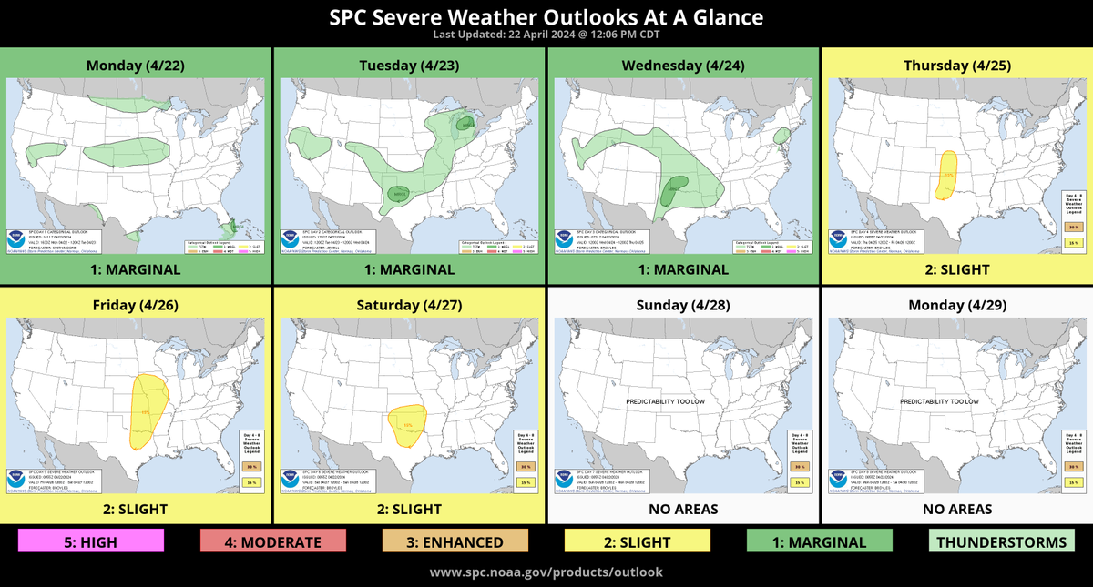
Looks like we have a chance of storms on Friday:
SPC wrote:
An active period of severe weather is expected Thu through the weekend across the Plains. All severe hazards are possible with the potential for significant severe weather. Specific corridors of greater risk are expected, but will not become more apparent until later in the week.
Omaha Skyline Photos, Omaha Aerial Photos, and More.
Website: www.bradwilliamsphotography.com
Facebook: www.facebook.com/bradwilliamsphotography
Twitter: www.twitter.com/bradwphoto
Instagram: www.instagram.com/bradwilliamsphotography
YouTube: www.youtube.com/@bradwilliamsphoto
-
stormchaser
- Planning Board
- Posts: 2380
- Joined: Fri Jun 01, 2018 8:14 am
Re: 2024 Weather Thread
Yep, possibly Thursday night some severe stuff as well (or it wouldn't surprise me anyway).Brad wrote: Mon Apr 22, 2024 2:33 pm Looks like we have a chance of storms on Friday:
SPC wrote:
An active period of severe weather is expected Thu through the weekend across the Plains. All severe hazards are possible with the potential for significant severe weather. Specific corridors of greater risk are expected, but will not become more apparent until later in the week.
-
stormchaser
- Planning Board
- Posts: 2380
- Joined: Fri Jun 01, 2018 8:14 am
Re: 2024 Weather Thread
The threat for potential tornadoes this Friday not far from the Omaha area continues to increase.
The highest risk currently is east of Omaha though like normal, it'll ultimately come down to timing and it's impossible to know this far out.
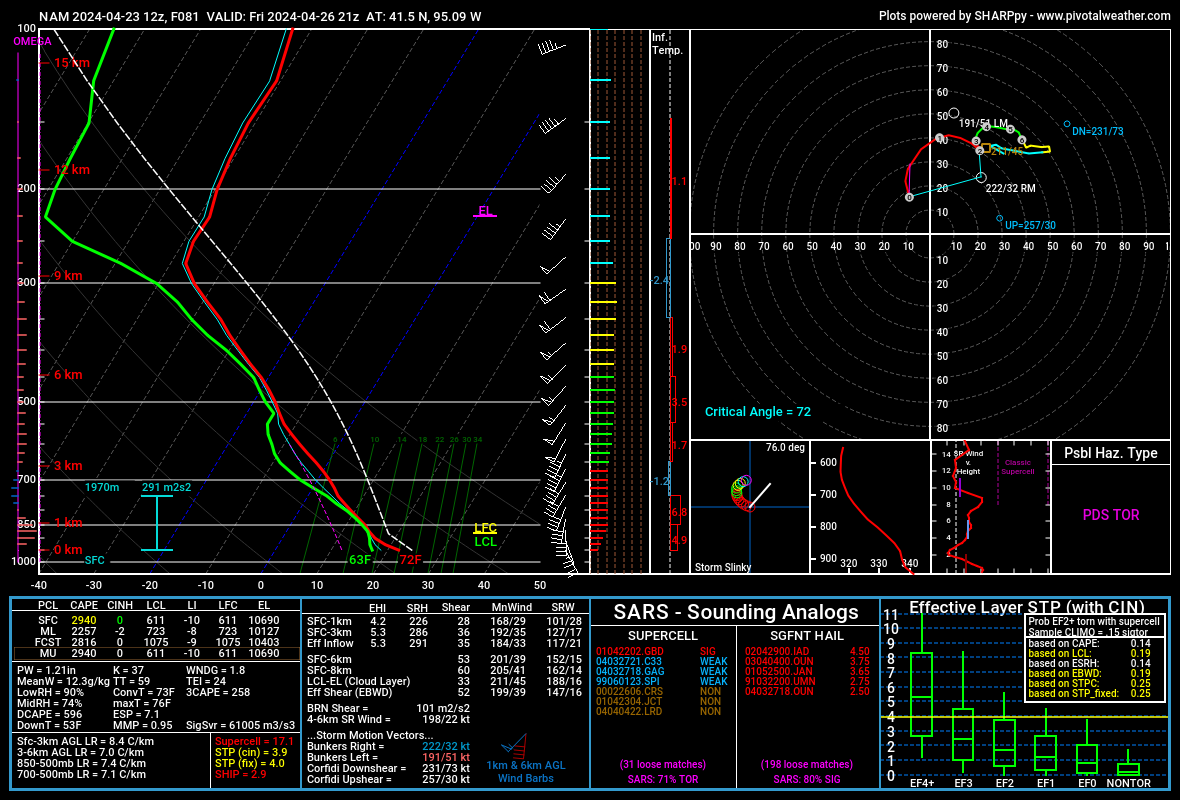
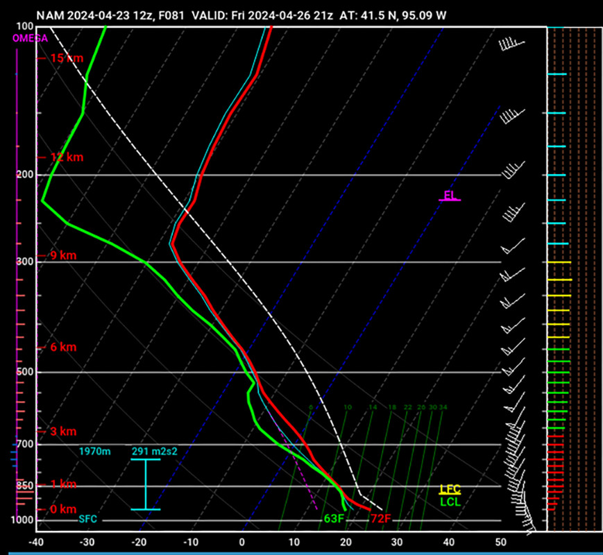
The skew-t soundings on the 12z NAM definitely show an environment favorable for tornadoes with the low pressure depicted to pass almost directly over Omaha itself during the later afternoon hours on Friday.
The sounding included in the image below is for just east of Omaha at 21z (4 PM).
It shows sufficient low level directional/speed shear, plenty of moisture depth, curved hodographs (albeit a big wonky in the image below with convection depicted in the same area), surface based cape near 3,000, LCL levels of around 600 so the bases of the storms should definitely be surface based, SRH values of over 200 (which is typically needed for potential for strong tornadoes), etc.
It's too far out to put too much weight into what's being shown currently, but the trends are looking increasingly dangerous anyway. Only time will tell if these trends continue on future models/model runs. If they continue, potential for strong tornadoes in the area will exist (probably somewhere between Omaha and Des Moines but who knows yet).
Regardless, don't be surprised if Omaha and/or areas just east of Omaha have their risk levels increased in the coming days.
The highest risk currently is east of Omaha though like normal, it'll ultimately come down to timing and it's impossible to know this far out.
The skew-t soundings on the 12z NAM definitely show an environment favorable for tornadoes with the low pressure depicted to pass almost directly over Omaha itself during the later afternoon hours on Friday.
The sounding included in the image below is for just east of Omaha at 21z (4 PM).
It shows sufficient low level directional/speed shear, plenty of moisture depth, curved hodographs (albeit a big wonky in the image below with convection depicted in the same area), surface based cape near 3,000, LCL levels of around 600 so the bases of the storms should definitely be surface based, SRH values of over 200 (which is typically needed for potential for strong tornadoes), etc.
It's too far out to put too much weight into what's being shown currently, but the trends are looking increasingly dangerous anyway. Only time will tell if these trends continue on future models/model runs. If they continue, potential for strong tornadoes in the area will exist (probably somewhere between Omaha and Des Moines but who knows yet).
Regardless, don't be surprised if Omaha and/or areas just east of Omaha have their risk levels increased in the coming days.
-
skinzfan23
- City Council
- Posts: 11628
- Joined: Mon Feb 09, 2004 11:26 am
- Location: Omaha/Bellevue
Re: 2024 Weather Thread
Thanks for the update....hopefully with more to come as it gets closer. My wife and I were going downtown to a concert on Friday night and I would hate to leave the kids home alone with a possibility of a tornado.
-
stormchaser
- Planning Board
- Posts: 2380
- Joined: Fri Jun 01, 2018 8:14 am
Re: 2024 Weather Thread
Will do, obviously plenty of time for things to completely change yetskinzfan23 wrote: Tue Apr 23, 2024 11:20 am Thanks for the update....hopefully with more to come as it gets closer. My wife and I were going downtown to a concert on Friday night and I would hate to leave the kids home alone with a possibility of a tornado.
-
stormchaser
- Planning Board
- Posts: 2380
- Joined: Fri Jun 01, 2018 8:14 am
Re: 2024 Weather Thread
It's worth mentioning this looks EXTREMELY similar to the storm system we had last week where it produced a few tornadoes not far from Columbus right where the low pressure was (which I managed to see one of them briefly).
Wouldn't surprise me if that scenario plays out again in a very similar area...
Wouldn't surprise me if that scenario plays out again in a very similar area...
-
thenewguy
- County Board
- Posts: 4329
- Joined: Fri Oct 19, 2007 9:50 pm
- Location: Council Bluffs
Re: 2024 Weather Thread
i seriously really wish i knew what each of these sections meant. I've seen those types of things before, but i don't know what each of them means
Go Cubs Go
-
stormchaser
- Planning Board
- Posts: 2380
- Joined: Fri Jun 01, 2018 8:14 am
Re: 2024 Weather Thread
It can look overwhelming but once you start to understand what you're looking at, they're fairly simple (though it takes time obviously and there are a ton of things to look for which takes experience).thenewguy wrote: Tue Apr 23, 2024 3:48 pm i seriously really wish i knew what each of these sections meant. I've seen those types of things before, but i don't know what each of them means
Here is a basic breakdown of how I use at least part of them anyway. I won't go over every piece in this reply because it's just too much to explain in a single reply. Keep in mind, I'm self-taught and not a Meteorologist
. Also keep in mind, this is a skew-t sounding from a forecast model so it doesn't necessarily represent what will end up happening. Each day you can see the actual skew-t soundings from the weather balloons that the NWS launches to get the actual measurements (at the time of the balloon launch anyway).Top left section (image below):
Think of this section like it's measurements that a weather balloon would take as it goes up from the surface of the Earth, all the way up into the stratosphere.
The scale on the far left represents "height" (in millibars - as the pressure changes the further you go up obviously - hence why your ears pop on airplanes, etc). This is from 1,000 mb at the surface all the way to 100 mb. Typically you'll find the main jet stream in the 250 mb to 300 mb range depending on the time of year and the 500 mb range is the approximate level where you'll find the winds that determine the direction of the storms(aka steering winds). If there is capping, you would see a wedge of warmer air somewhere typically around the 700 mb range (this skew-t sounding does not show any capping). There is also a scale to the right of this that shows height in more conventional terms (in KM).
The scale at the bottom represents temperature (in Celsius though it shows the specific Fahrenheit temps as well for simplicity).
To the right of the heigh scale, the green curvy relatively vertical line represents the dewpoint temperature from the surface all the way up, the red line represents the air temperature from the surface all the way up. The white dashed line represents the area of CAPE (the convective available potential energy - aka instability). The larger this area of CAPE, the more unstable the atmosphere typically is (though that doesn't automatically mean storms will occur - just to clarify). If the red curvy line and green curvy line come together, that typically is showing that precip is occurring at that level as the dewpoint and air temp are equal (so the humidity is 100%) - so in this case, this skew-t is showing a storm that is depicted to be occurring at the location of the skew-t. To clarify, you don't need to find a skew-t that is showing a storm like this one does (in fact, it would be better to not have that probably), you should more be looking at the overall environment for IF storms were to occur.
The green LCL/yellow LFC in the bottom right corner of this section basically represents the level where you will find the base of the clouds/storms. For tornadoes, you typically want the base of the storms to be below 1,000 mb (in this case they are depicted to be around 600 mb). Otherwise if the bases are too high up, the storms would be known as "elevated storms" and typically produce more of a damaging wind threat (depending on the setup anyway).
The white "arrow" looking icons (to the right of where it says LFC/LCL in green/yellow) represents the wind direction and strength of the wind at each level of the atmosphere. When an environment is favorable for supercells/tornadoes, you'll see a "twisting" motion with direction of the wind as you go from the surface on up through where the storms would be with more of a northeasterly wind aloft (which is why you'll see the anvil of a storm pushed out sometimes 100+ miles out ahead of a storm). In particular you're looking for strong low level winds preferably out of the east/southeast which this skew-t shows to an extent (though it isn't completely ideal in this case either - rarely will you get. a setup where everything looks ideal for tornadoes). Having a east/southeast wind is often referred to as "backed" surface winds and it leads to the inflow you need for tornadoes (it's where the "notch" or "hook" comes from that you see on radar with tornadic storms - or at least contributes to it anyway).
This is just the top left section to get you started. There obviously are tons of other things to look at and look for with these but I don't want to overwhelm you with my dorky weather knowledge as I could keep going and going and going.
Anyhow, hope it helps!
Also, here is a video that you can watch that should help.
Last edited by stormchaser on Tue Apr 23, 2024 9:04 pm, edited 2 times in total.
-
almighty_tuna
- City Council
- Posts: 106374
- Joined: Tue Apr 13, 2004 1:34 pm
- Location: Somewhere between downtown and Colorado
Re: 2024 Weather Thread
This should be pinned. Excellent write-up!
-
stormchaser
- Planning Board
- Posts: 2380
- Joined: Fri Jun 01, 2018 8:14 am
Re: 2024 Weather Thread
Thanks!
-
stormchaser
- Planning Board
- Posts: 2380
- Joined: Fri Jun 01, 2018 8:14 am
Re: 2024 Weather Thread
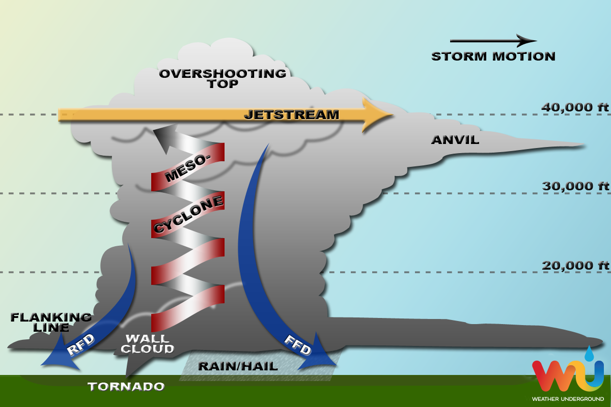
Now if you take that skew-t sounding I did a basic breakdown of above and then look at this "schematic" of what is happening in a supercell, it starts to really make sense how things are coming together with these types of storms.
-
Busguy2010
- City Council
- Posts: 7325
- Joined: Sat Apr 09, 2011 7:32 pm
- Location: North Central Omaha
Re: 2024 Weather Thread
Just responding to the above graphic. I'll never forget 5/11/2014. That supercell was the most prime example I can recall in my life that hit Omaha directly. The anvil extended hundreds of miles and hours ahead of the mesocyclone's arrival. It was huge. There was so much energy with that storm. Most of the time we get QLCS, and as we all know, they break up most of the time. Theres been a couple damaging thunderstorms since then, but we haven't had a true, bonafide, isolated supercell thunderstorm since 2014. It was a true spectacle.
-
thenewguy
- County Board
- Posts: 4329
- Joined: Fri Oct 19, 2007 9:50 pm
- Location: Council Bluffs
Re: 2024 Weather Thread
@stormchaser...
holy |expletive|, that's a fantastic explanation, thank you!! I've always been fascinated by weather, as many of us are, it's awesome to get some insight as to what you all talk about!
holy |expletive|, that's a fantastic explanation, thank you!! I've always been fascinated by weather, as many of us are, it's awesome to get some insight as to what you all talk about!
Go Cubs Go
-
Brad
- Photographer
- Posts: 1036553
- Joined: Sat Feb 28, 2004 6:03 pm
- Location: Omaha, NE
Re: 2024 Weather Thread
I have watched a lot of skew-t videos over the years and this one is still the best out there. Also, for those of you that liked his video, that was only part 1 of a 17 video series.stormchaser wrote: Tue Apr 23, 2024 4:27 pm Also, here is a video that you can watch that should help.
That said, as many times as I have watched it, there are still things I don't fully understand. I know just enough to be dangerous.
Omaha Skyline Photos, Omaha Aerial Photos, and More.
Website: www.bradwilliamsphotography.com
Facebook: www.facebook.com/bradwilliamsphotography
Twitter: www.twitter.com/bradwphoto
Instagram: www.instagram.com/bradwilliamsphotography
YouTube: www.youtube.com/@bradwilliamsphoto
-
stormchaser
- Planning Board
- Posts: 2380
- Joined: Fri Jun 01, 2018 8:14 am
Re: 2024 Weather Thread
No problem - happy to help!thenewguy wrote: Wed Apr 24, 2024 7:39 am @stormchaser...
holy |expletive|, that's a fantastic explanation, thank you!! I've always been fascinated by weather, as many of us are, it's awesome to get some insight as to what you all talk about!
I 100% agree!Brad wrote: Wed Apr 24, 2024 8:54 am I have watched a lot of skew-t videos over the years and this one is still the best out there. Also, for those of you that liked his video, that was only part 1 of a 17 video series.
-
thenewguy
- County Board
- Posts: 4329
- Joined: Fri Oct 19, 2007 9:50 pm
- Location: Council Bluffs
Re: 2024 Weather Thread
lol. For what it's worth, i actually said "holy c-r-a-p" and it expletive'd itstormchaser wrote: Wed Apr 24, 2024 12:56 pmNo problem - happy to help!thenewguy wrote: Wed Apr 24, 2024 7:39 am @stormchaser...
holy |expletive|, that's a fantastic explanation, thank you!! I've always been fascinated by weather, as many of us are, it's awesome to get some insight as to what you all talk about!
I 100% agree!Brad wrote: Wed Apr 24, 2024 8:54 am I have watched a lot of skew-t videos over the years and this one is still the best out there. Also, for those of you that liked his video, that was only part 1 of a 17 video series.
Go Cubs Go