2024 Weather Thread
-
stormchaser

- Planning Board
- Posts: 2380
- Joined: Fri Jun 01, 2018 8:14 am
Re: 2024 Weather Thread
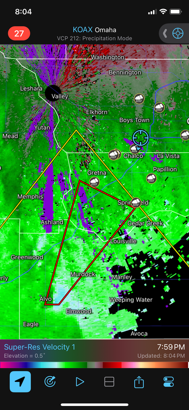
Tornado warning
-
stormchaser
- Planning Board
- Posts: 2380
- Joined: Fri Jun 01, 2018 8:14 am
Re: 2024 Weather Thread
Likely rain wrapped if there is one…
-
Busguy2010

- City Council
- Posts: 7328
- Joined: Sat Apr 09, 2011 7:32 pm
- Location: North Central Omaha
Re: 2024 Weather Thread
Other than the rain, pretty meh. Nothing spectacular as far as thunder and lightning.
-
Louie
- County Board
- Posts: 4936
- Joined: Fri Dec 23, 2011 4:23 pm
- Location: Dundee
Re: 2024 Weather Thread
I think its spectacular in the rainfall. We need every drop.Busguy2010 wrote: Mon May 06, 2024 9:15 pm Other than the rain, pretty meh. Nothing spectacular as far as thunder and lightning.
-
stormchaser
- Planning Board
- Posts: 2380
- Joined: Fri Jun 01, 2018 8:14 am
Re: 2024 Weather Thread
Minden, IA may have just got hit again by a tornado. If not, probably super close (if there was one).
This would have been a weak one I’m sure but still…
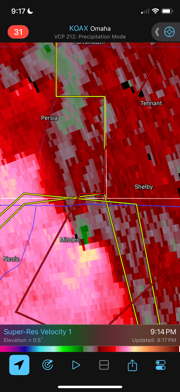
This would have been a weak one I’m sure but still…
-
Busguy2010
- City Council
- Posts: 7328
- Joined: Sat Apr 09, 2011 7:32 pm
- Location: North Central Omaha
Re: 2024 Weather Thread
Great rainfall, yeah. And almost immediately after I said that, boom, we got a few nice CG strikes like it heard me.Louie wrote: Mon May 06, 2024 9:21 pmI think its spectacular in the rainfall. We need every drop.Busguy2010 wrote: Mon May 06, 2024 9:15 pm Other than the rain, pretty meh. Nothing spectacular as far as thunder and lightning.
-
Padre
- Human Relations
- Posts: 925
- Joined: Thu Jul 27, 2017 9:53 pm
- Location: Omaha
Re: 2024 Weather Thread
Sounds like it just missed.stormchaser wrote: Mon May 06, 2024 9:23 pm Minden, IA may have just got hit again by a tornado. If not, probably super close (if there was one).
This would have been a weak one I’m sure but still…
-
CBJason
- Library Board
- Posts: 416
- Joined: Fri Apr 08, 2022 4:01 pm
- Location: MEM burbs
Re: 2024 Weather Thread
Yesterday afternoon Fedex pulled a rare Ops move by pulling the a/c out early that were sitting in OMA, ICT, TUL and OKC because of this system that was going through.stormchaser wrote: Mon May 06, 2024 7:17 am Still looking like more of a damaging wind/hail threat today in the Omaha area than a tornado threat though I still believe there will probably be a few tornadoes near the KS/NE border - in general, things are looking pretty linear in our area anyway.
Storms should fire around Noon out near the Kearney area and probably go severe fairly quick. These storms may at times take on a supercellular structure before growing upscale into a line. This line will probably have some embedded supercells as it pushes east across NE so there will be at least some tornado threat - but the main threat should be damaging wind/hail.
-
stormchaser
- Planning Board
- Posts: 2380
- Joined: Fri Jun 01, 2018 8:14 am
Re: 2024 Weather Thread
Crazy - probably for the best though just o keep everyone safe, especially down south in parts of KS/OK.CBJason wrote: Tue May 07, 2024 9:17 amYesterday afternoon Fedex pulled a rare Ops move by pulling the a/c out early that were sitting in OMA, ICT, TUL and OKC because of this system that was going through.stormchaser wrote: Mon May 06, 2024 7:17 am Still looking like more of a damaging wind/hail threat today in the Omaha area than a tornado threat though I still believe there will probably be a few tornadoes near the KS/NE border - in general, things are looking pretty linear in our area anyway.
Storms should fire around Noon out near the Kearney area and probably go severe fairly quick. These storms may at times take on a supercellular structure before growing upscale into a line. This line will probably have some embedded supercells as it pushes east across NE so there will be at least some tornado threat - but the main threat should be damaging wind/hail.
Looking at long range models, our pattern is starting to calm down some and right now there aren't any storm systems that jump out at me for our area that would bring severe weather (at least nothing widespread). Of course that can quickly change but for now it's looking relatively calm for the next ~10 days.
-
damonhynes

- Parks & Recreation
- Posts: 1278
- Joined: Tue Aug 26, 2014 7:35 pm
- Location: Montgomery County, Texas
Re: 2024 Weather Thread
That used to be a tried and true canary in the coal mine when Offutt Weather would suggest that the base's aircraft should bug out. "Are the planes leaving?"CBJason wrote: Tue May 07, 2024 9:17 am
Yesterday afternoon Fedex pulled a rare Ops move by pulling the a/c out early that were sitting in OMA, ICT, TUL and OKC because of this system that was going through.
-
stormchaser
- Planning Board
- Posts: 2380
- Joined: Fri Jun 01, 2018 8:14 am
Re: 2024 Weather Thread
A total of 4 confirmed tornadoes from Monday night - mostly just east of Omaha...
https://www.ketv.com/article/nebraska-i ... e/60729355
https://www.ketv.com/article/nebraska-i ... e/60729355
-
stormchaser
- Planning Board
- Posts: 2380
- Joined: Fri Jun 01, 2018 8:14 am
Re: 2024 Weather Thread
Probably a few isolated strong/severe storms in Iowa today with at least a low end risk for a tornado. Not a huge outbreak or anything but some people may be surprised to see warnings off to the east/northeast of Omaha.
-
Louie
- County Board
- Posts: 4936
- Joined: Fri Dec 23, 2011 4:23 pm
- Location: Dundee
Re: 2024 Weather Thread
Couple of nice rounds of rain on the eastern half of the city already.
-
skinzfan23

- City Council
- Posts: 11629
- Joined: Mon Feb 09, 2004 11:26 am
- Location: Omaha/Bellevue
Re: 2024 Weather Thread
I just checked my gauge and I got right around 1" since yesterday afternoon.
-
stormchaser
- Planning Board
- Posts: 2380
- Joined: Fri Jun 01, 2018 8:14 am
Re: 2024 Weather Thread
It's way too far out to have much confidence but the ECMWF (including the most recent 00z run) has consistently been showing a severe weather threat/potential tornado threat in our area next Tuesday (May 21st) with a strong ~994mb low depicted to pass near or over our area during peak heating (and with dewpoints depicted to be approaching 70 so it'll feel gross outside if that happens).
Again, it's way too far out but it's something to keep a very close eye on as we get closer anyway.
Otherwise between now and then there "might" be a few chances for isolated strong/severe storms but in general, relatively quiet when it comes to severe weather in our area (unless things change of course but that's how it looks currently) though there will be some scattered rain/thunder chances anyway with the best chance tomorrow/tomorrow night.
Again, it's way too far out but it's something to keep a very close eye on as we get closer anyway.
Otherwise between now and then there "might" be a few chances for isolated strong/severe storms but in general, relatively quiet when it comes to severe weather in our area (unless things change of course but that's how it looks currently) though there will be some scattered rain/thunder chances anyway with the best chance tomorrow/tomorrow night.
-
stormchaser
- Planning Board
- Posts: 2380
- Joined: Fri Jun 01, 2018 8:14 am
Re: 2024 Weather Thread
Finally there is starting to be some model agreement in what to expect the next few days so here is the updated info.
We will probably get some storms later today/this evening. A few isolated strong/severe storms will be possible (damaging wind/hail though the risk is pretty low).
Then this Sunday/Monday (May 19/20) is now looking like the main severe weather risk days for our area (with 2 separate severe weather threats) though timing of everything is unknown. Based on the 00z ECMWF, Sunday would have a threat for damaging wind, large hail, and tornadoes (possibly an elevated threat for tornadoes with a low pressure nearby) in or near our area IF things verify as shown and then probably a damaging wind/hail threat Monday during the overnight hours into early Tuesday.
Since models haven't been great though as of late, don't be surprised if things change as medium and eventually short range models start to pick up on things but also don't be surprised to see the SPC start putting out risk areas in or close to our region in the coming days as well.
We will probably get some storms later today/this evening. A few isolated strong/severe storms will be possible (damaging wind/hail though the risk is pretty low).
Then this Sunday/Monday (May 19/20) is now looking like the main severe weather risk days for our area (with 2 separate severe weather threats) though timing of everything is unknown. Based on the 00z ECMWF, Sunday would have a threat for damaging wind, large hail, and tornadoes (possibly an elevated threat for tornadoes with a low pressure nearby) in or near our area IF things verify as shown and then probably a damaging wind/hail threat Monday during the overnight hours into early Tuesday.
Since models haven't been great though as of late, don't be surprised if things change as medium and eventually short range models start to pick up on things but also don't be surprised to see the SPC start putting out risk areas in or close to our region in the coming days as well.
-
nebugeater

- City Council
- Posts: 110954
- Joined: Wed Aug 04, 2004 6:07 pm
- Location: Gretna NE
Re: 2024 Weather Thread
I moved the posts that I started by asking about the weather for smoking meat and inadvertently derailed this topic to a new thread.
viewtopic.php?p=397192#p397192
viewtopic.php?p=397192#p397192
For the record NEBUGEATER does not equal BUGEATER !!!!!!!
-
nativeomahan

- County Board
- Posts: 6013
- Joined: Fri Nov 12, 2004 2:46 pm
- Location: Omaha and Puerto Vallarta
Re: 2024 Weather Thread
Life is so full of ironies.
-
Louie
- County Board
- Posts: 4936
- Joined: Fri Dec 23, 2011 4:23 pm
- Location: Dundee
Re: 2024 Weather Thread
A real drencher indeed
-
Padre
- Human Relations
- Posts: 925
- Joined: Thu Jul 27, 2017 9:53 pm
- Location: Omaha
Re: 2024 Weather Thread
And a reminder of why Saddle Creek got its name!
-
Coyote

- City Council
- Posts: 34366
- Joined: Tue Nov 18, 2003 11:18 am
- Location: Aksarben Village
Re: 2024 Weather Thread
It was 1896 when Omaha founding father A.D. Jones recounted the story of how he named Saddle Creek in 1854. He was on a trip to Elkhorn when he lost his saddle in the creek and gave it his name. In his storytelling he said, “As the little stream had no other ‘white’ name I called it Saddle Creek and Saddle Creek it has been ever since.” By 1898, the City of Omaha was planning to put a boulevard along the Saddle Creek.
-
BRoss

- IT Director
- Posts: 10003378
- Joined: Fri Aug 04, 2006 7:39 pm
- Location: West Central Omaha
Re: 2024 Weather Thread
It's interesting how there was such a wide range on rain amounts in the city. A lot of southwest Omaha didn't get a lot. I only got a little more than a quarter inch. But areas within the 680 loop and northwest north of Maple got over an inch and a half to two inches.
We should be close to getting out of this drought.
We should be close to getting out of this drought.
-
Busguy2010
- City Council
- Posts: 7328
- Joined: Sat Apr 09, 2011 7:32 pm
- Location: North Central Omaha
Re: 2024 Weather Thread
I really wasn't expecting that. With a 40% chance, I usually expect a random pop up shower that lasts a few minutes, but for me, it was a complete washout for 45 minutes- hour and was severe warned. Surely unfortunate timing for me to lay down grass seed yesterday. It's all gone.
-
Brad

- Photographer
- Posts: 1036559
- Joined: Sat Feb 28, 2004 6:03 pm
- Location: Omaha, NE
Re: 2024 Weather Thread
Near 90th and Center, I got 1.67 inches total..... But....
Big Story, between 4:33 and 4:51 I got 1.51” of rain! That equals a rate of 4.5 inches per hour, just crazy.
Also, just noticed a new line forming to our west on radar...
Big Story, between 4:33 and 4:51 I got 1.51” of rain! That equals a rate of 4.5 inches per hour, just crazy.
Also, just noticed a new line forming to our west on radar...

Omaha Skyline Photos, Omaha Aerial Photos, and More.
Website: www.bradwilliamsphotography.com
Facebook: www.facebook.com/bradwilliamsphotography
Twitter: www.twitter.com/bradwphoto
Instagram: www.instagram.com/bradwilliamsphotography
YouTube: www.youtube.com/@bradwilliamsphoto
-
skinzfan23
- City Council
- Posts: 11629
- Joined: Mon Feb 09, 2004 11:26 am
- Location: Omaha/Bellevue
Re: 2024 Weather Thread
Only got .25” , but I am really glad that I mowed last night
-
thenewguy
- County Board
- Posts: 4333
- Joined: Fri Oct 19, 2007 9:50 pm
- Location: Council Bluffs
Re: 2024 Weather Thread
ain't it though? I don't know what we had for rain at my house, but it absolutely poured for like 25 minutes.
Edit: according to someone that lives near me (that has an ambient weather station) we got 1.67" of rain on the west end of CB. I really need to get myself one...
Go Cubs Go
-
Brad
- Photographer
- Posts: 1036559
- Joined: Sat Feb 28, 2004 6:03 pm
- Location: Omaha, NE
Re: 2024 Weather Thread
Here is one similar to mine, but mine is 5+ years older. Rain is very accurate, wind speed is questionable.thenewguy wrote: Thu May 16, 2024 7:10 am Edit: according to someone that lives near me (that has an ambient weather station) we got 1.67" of rain on the west end of CB. I really need to get myself one...
https://www.amazon.com/AcuRite-01540M-W ... EBEALw_wcB
Omaha Skyline Photos, Omaha Aerial Photos, and More.
Website: www.bradwilliamsphotography.com
Facebook: www.facebook.com/bradwilliamsphotography
Twitter: www.twitter.com/bradwphoto
Instagram: www.instagram.com/bradwilliamsphotography
YouTube: www.youtube.com/@bradwilliamsphoto
-
EastCB
- Library Board
- Posts: 383
- Joined: Thu Oct 05, 2006 11:30 am
- Location: Council Bluffs
Re: 2024 Weather Thread
I got 1.65 in EastCB. Lots of lightning but no wind or hail.
-
thenewguy
- County Board
- Posts: 4333
- Joined: Fri Oct 19, 2007 9:50 pm
- Location: Council Bluffs
Re: 2024 Weather Thread
thank you!Brad wrote: Thu May 16, 2024 8:25 amHere is one similar to mine, but mine is 5+ years older. Rain is very accurate, wind speed is questionable.thenewguy wrote: Thu May 16, 2024 7:10 am Edit: according to someone that lives near me (that has an ambient weather station) we got 1.67" of rain on the west end of CB. I really need to get myself one...
https://www.amazon.com/AcuRite-01540M-W ... EBEALw_wcB
Go Cubs Go
-
stormchaser
- Planning Board
- Posts: 2380
- Joined: Fri Jun 01, 2018 8:14 am
Re: 2024 Weather Thread
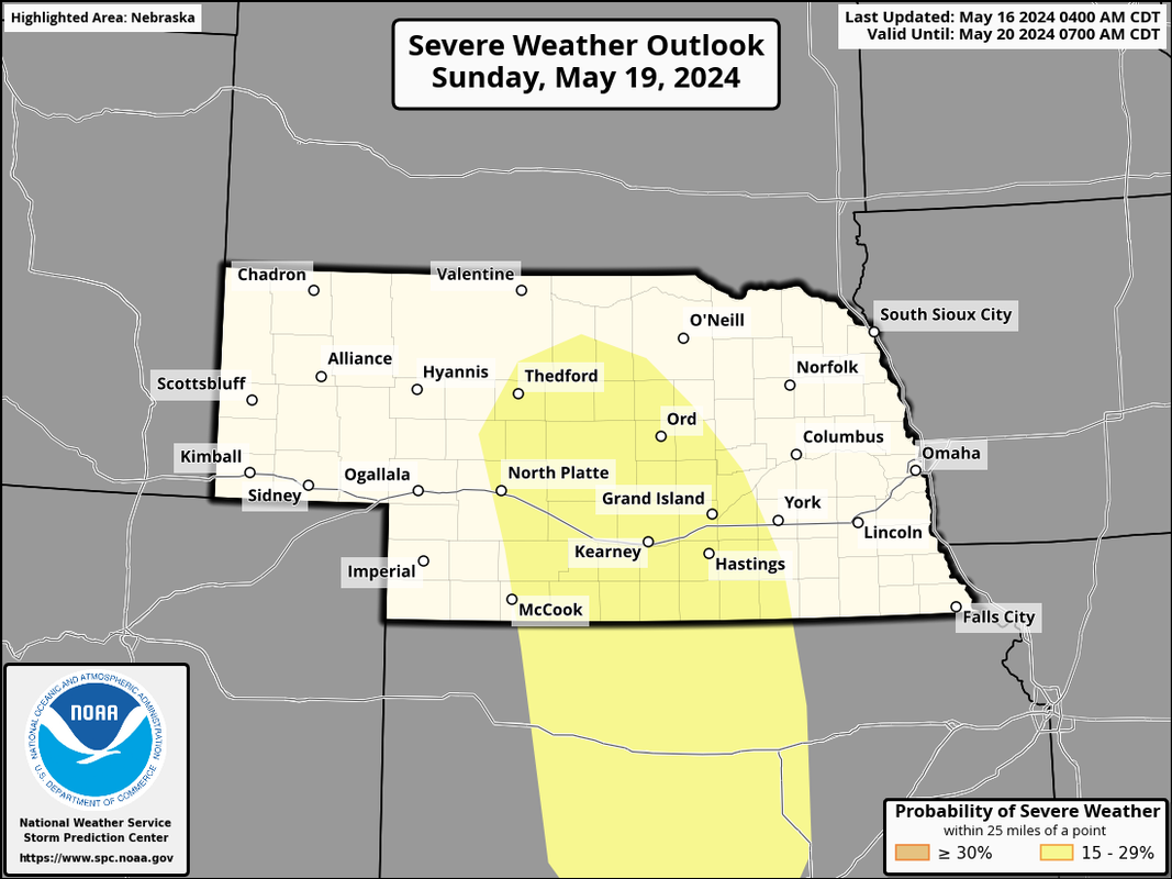
Day 4 severe weather outlook is out for this coming Sunday - it's a bit further west than I was expecting as I feel there is risk here too but it's less certain currently anyway. All storm modes will be possible including a threat for tornadoes.
-
stormchaser
- Planning Board
- Posts: 2380
- Joined: Fri Jun 01, 2018 8:14 am
Re: 2024 Weather Thread
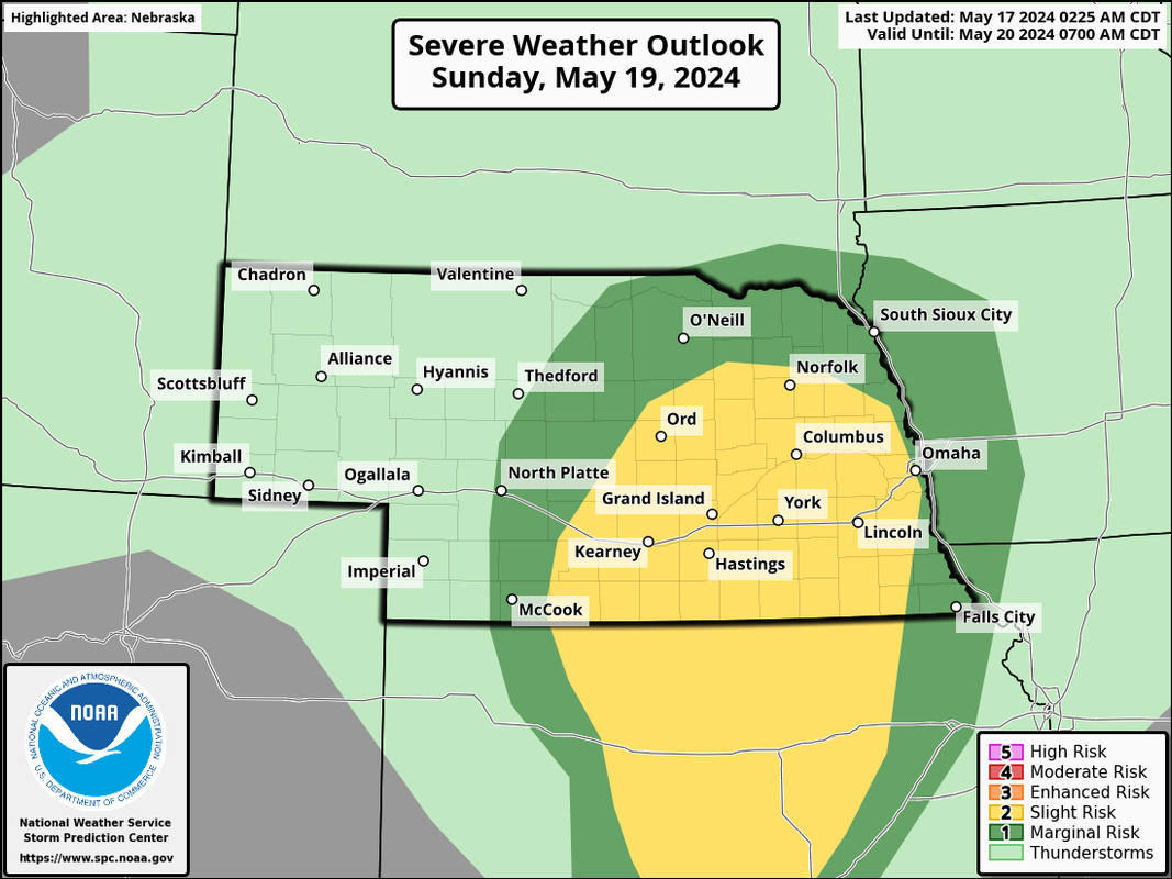
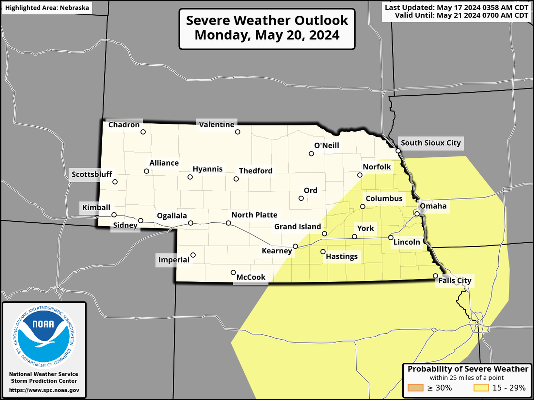
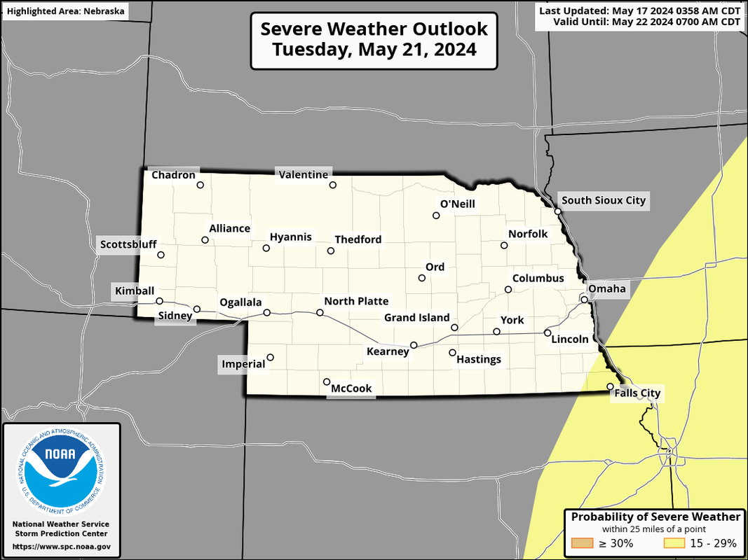
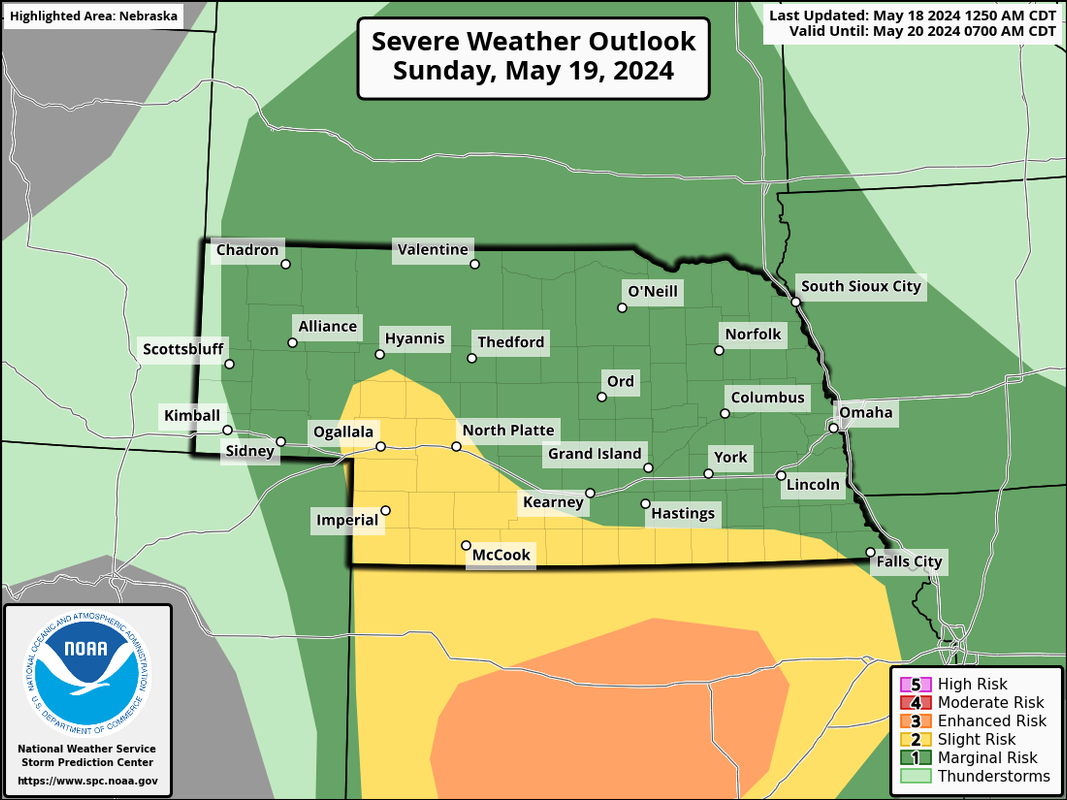
Updated severe weather outlooks from the SPC for Sunday, Monday, and Tuesday (though that risk is just barely east of us currently on Tuesday). The Sunday outlook now aligns with more of what I was thinking would be the area at risk.
Sunday:
Some uncertainty exists for the risk on Sunday including the potential for ongoing/lingering showers/thunderstorms in the morning/early afternoon hours that may degrade the atmospheric conditions for redevelopment later in the afternoon and there is also potential for capping issues. However, based on the latest NAM forecast model, the capping does break during the afternoon/early evening.
I suspect there will be some morning/early afternoon convection on Sunday somewhere in our area but exactly where will be key as it will likely produce an east/west boundary just south of this area of precip that would probably be a focus for supercells and potential tornadoes during the late afternoon/early evening hours. Long story short, still lots of things to figure out as we get closer.
Anyhow, here is the outlook from the SPC for Sunday:
Monday:
The risk on Monday looks to be more of an evening/overnight risk as a cold front drops into the area bringing with it mostly a risk of damaging wind/hail.
Tuesday:
Sunday:
Some uncertainty exists for the risk on Sunday including the potential for ongoing/lingering showers/thunderstorms in the morning/early afternoon hours that may degrade the atmospheric conditions for redevelopment later in the afternoon and there is also potential for capping issues. However, based on the latest NAM forecast model, the capping does break during the afternoon/early evening.
I suspect there will be some morning/early afternoon convection on Sunday somewhere in our area but exactly where will be key as it will likely produce an east/west boundary just south of this area of precip that would probably be a focus for supercells and potential tornadoes during the late afternoon/early evening hours. Long story short, still lots of things to figure out as we get closer.
Anyhow, here is the outlook from the SPC for Sunday:
Monday:
The risk on Monday looks to be more of an evening/overnight risk as a cold front drops into the area bringing with it mostly a risk of damaging wind/hail.
Tuesday:
-
stormchaser
- Planning Board
- Posts: 2380
- Joined: Fri Jun 01, 2018 8:14 am
Re: 2024 Weather Thread
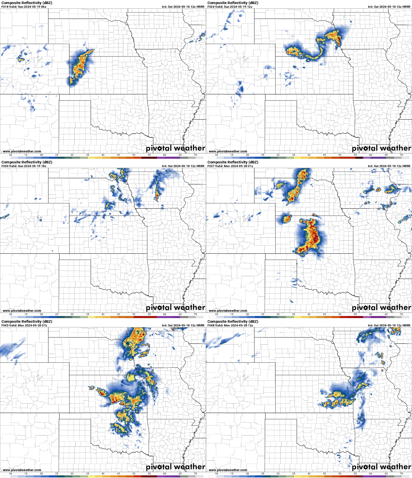
As I mentioned above, the overnight/first part of Sunday convection may inhibit storm redevelopment in our area Sunday. Based on recent model runs (and updated outlook from the SPC), that appears pretty likely to happens so severe weather in Omaha tomorrow is less likely.
Latest SPC outlook for tomorrow showing the risk being pushed down into KS due to an outflow boundary from the overnight/first part of Sunday convection in our area.
Here is an animation of the simulated radar from the 12z HRRR starting at around Midnight tonight showing the convection moving through our area which would inhibit storm redevelopment on Sunday:
Latest SPC outlook for tomorrow showing the risk being pushed down into KS due to an outflow boundary from the overnight/first part of Sunday convection in our area.
Here is an animation of the simulated radar from the 12z HRRR starting at around Midnight tonight showing the convection moving through our area which would inhibit storm redevelopment on Sunday:
-
Omaha Cowboy

- The Don
- Posts: 1013719
- Joined: Wed Jan 07, 2004 5:31 am
- Location: West Omaha
Re: 2024 Weather Thread
I’m hearing Omaha will also be in an Enhanced Risk (2 of 5) for severe weather this Monday as well..
Any extra intel on that stormchaser?…
Ciao..LiO…Peace
Any extra intel on that stormchaser?…
Ciao..LiO…Peace
Go Cowboys!
-
stormchaser
- Planning Board
- Posts: 2380
- Joined: Fri Jun 01, 2018 8:14 am
Re: 2024 Weather Thread
It’s certainly possible but if it does happen, it would be for mostly a damaging wind/hail threat during the evening overnight hours as capping looks pretty strong much of the day Monday in our area.Omaha Cowboy wrote: Sat May 18, 2024 2:32 pm I’m hearing Omaha will also be in an Enhanced Risk (2 of 5) for severe weather this Monday as well..
Any extra intel on that stormchaser?…
Ciao..LiO…Peace
Tuesday looks like a bigger severe weather day in and/or just east of Omaha (though in Omaha it will depend on timing).
Storm development should occur here or just east of here during the early/mid-afternoon hours with all storm modes possible Tuesday with storms probably growing upscale into a damaging wind/hail threat in much of IA Tuesday afternoon/evening.
Supercells/tornadoes will be possible and that risk “might” be greatest near Omaha and/or just to our east into western IA early on as storms first develop as they’re more isolated initially so that will need to be watched closely.
-
Omaha Cowboy
- The Don
- Posts: 1013719
- Joined: Wed Jan 07, 2004 5:31 am
- Location: West Omaha
Re: 2024 Weather Thread
Thank you as always for your insightful updatesstormchaser wrote: Sat May 18, 2024 4:50 pmIt’s certainly possible but if it does happen, it would be for mostly a damaging wind/hail threat during the evening overnight hours as capping looks pretty strong much of the day Monday in our area.Omaha Cowboy wrote: Sat May 18, 2024 2:32 pm I’m hearing Omaha will also be in an Enhanced Risk (2 of 5) for severe weather this Monday as well..
Any extra intel on that stormchaser?…
Ciao..LiO…Peace
Tuesday looks like a bigger severe weather day in and/or just east of Omaha (though in Omaha it will depend on timing).
Storm development should occur here or just east of here during the early/mid-afternoon hours with all storm modes possible Tuesday with storms probably growing upscale into a damaging wind/hail threat in much of IA Tuesday afternoon/evening.
Supercells/tornadoes will be possible and that risk “might” be greatest near Omaha and/or just to our east into western IA early on as storms first develop as they’re more isolated initially so that will need to be watched closely.
 …
…Ciao..LiO…Peace
Go Cowboys!
-
stormchaser
- Planning Board
- Posts: 2380
- Joined: Fri Jun 01, 2018 8:14 am
Re: 2024 Weather Thread
No problem!Omaha Cowboy wrote: Sat May 18, 2024 5:29 pm Thank you as always for your insightful updates
Ciao..LiO…Peace
-
stormchaser
- Planning Board
- Posts: 2380
- Joined: Fri Jun 01, 2018 8:14 am
Re: 2024 Weather Thread
Potential for strong to severe storms tomorrow (Sunday) including a risk of tornadoes seems to be increasing again in parts of Nebraska based on short range model trends - especially from I-80 on south around the Grand Island/York/Lincoln area down to the KS border (and then into KS too of course). I wouldn’t be surprised if the SPC reintroduces the slight risk in parts of the area if the convection clears off in time for things to destabilize. If it does, the atmosphere will be conducive for severe weather…
-
stormchaser
- Planning Board
- Posts: 2380
- Joined: Fri Jun 01, 2018 8:14 am
Re: 2024 Weather Thread
Ehh, based on radar trends I can’t imagine things will destabilize enough for severe weather in our region later today. West of us (in central NE) and down into KS a pretty widespread damaging wind/hail threat.
Otherwise Monday/Tuesday are still looking like bigger severe weather threats in or near the local area with a potentially sizeable tornado threat Tuesday.
Otherwise Monday/Tuesday are still looking like bigger severe weather threats in or near the local area with a potentially sizeable tornado threat Tuesday.
-
stormchaser
- Planning Board
- Posts: 2380
- Joined: Fri Jun 01, 2018 8:14 am
Re: 2024 Weather Thread
Today/Tonight:
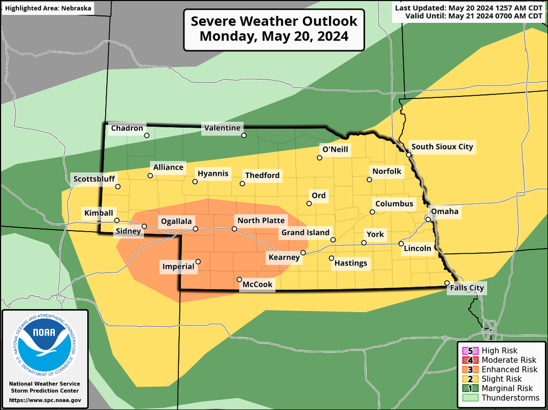
Strong to severe storms are possible this evening/overnight across much of Nebraska (including Omaha). There is a tornado threat out near MCcook/southwest NE. Our main threat in Omaha will probably be damaging wind (especially) and large hail during the night/overnight hours tonight. Heavy rainfall is also fairly likely tonight in parts of the area.
SPC outlook for today:
Tomorrow (Tuesday):
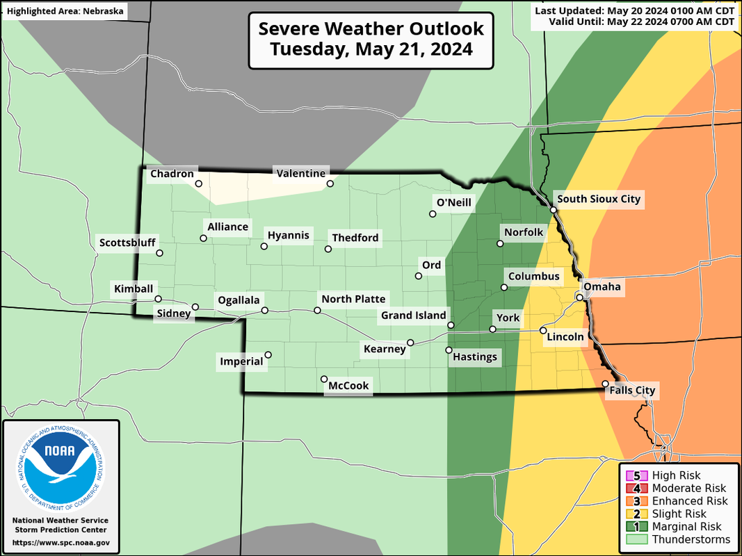
Tuesday is looking like potentially a dangerous day with the potential for a tornado outbreak including a threat for strong tornadoes. This risk is higher currently to the east of Omaha but it will come down to the exact timing that everything pushes through and if storms are initially linear before becoming more supercellular.
I'd expect Omaha to get some severe weather tomorrow IF storms fire as early as depicted on short range models (possibly near or before Noon in our area) with the tornado threat really ramping up as these storms move into IA. Our threat here in the local area may be more of a damaging wind/hail threat (and some tornado threat too).
SPC outlook for Tuesday:
Strong to severe storms are possible this evening/overnight across much of Nebraska (including Omaha). There is a tornado threat out near MCcook/southwest NE. Our main threat in Omaha will probably be damaging wind (especially) and large hail during the night/overnight hours tonight. Heavy rainfall is also fairly likely tonight in parts of the area.
SPC outlook for today:
Tomorrow (Tuesday):
Tuesday is looking like potentially a dangerous day with the potential for a tornado outbreak including a threat for strong tornadoes. This risk is higher currently to the east of Omaha but it will come down to the exact timing that everything pushes through and if storms are initially linear before becoming more supercellular.
I'd expect Omaha to get some severe weather tomorrow IF storms fire as early as depicted on short range models (possibly near or before Noon in our area) with the tornado threat really ramping up as these storms move into IA. Our threat here in the local area may be more of a damaging wind/hail threat (and some tornado threat too).
SPC outlook for Tuesday:
-
stormchaser
- Planning Board
- Posts: 2380
- Joined: Fri Jun 01, 2018 8:14 am
Re: 2024 Weather Thread
12z HRRR has shifted the risk tomorrow west some which means if this happens, Omaha would be at a higher risk for tornadoes (including strong tornadoes). A trend that will need to be watched closely on future model runs...
Simulated radar based on the 12z HRRR starting around 10 AM (showing potential supercell moving through locally in the early afternoon)...
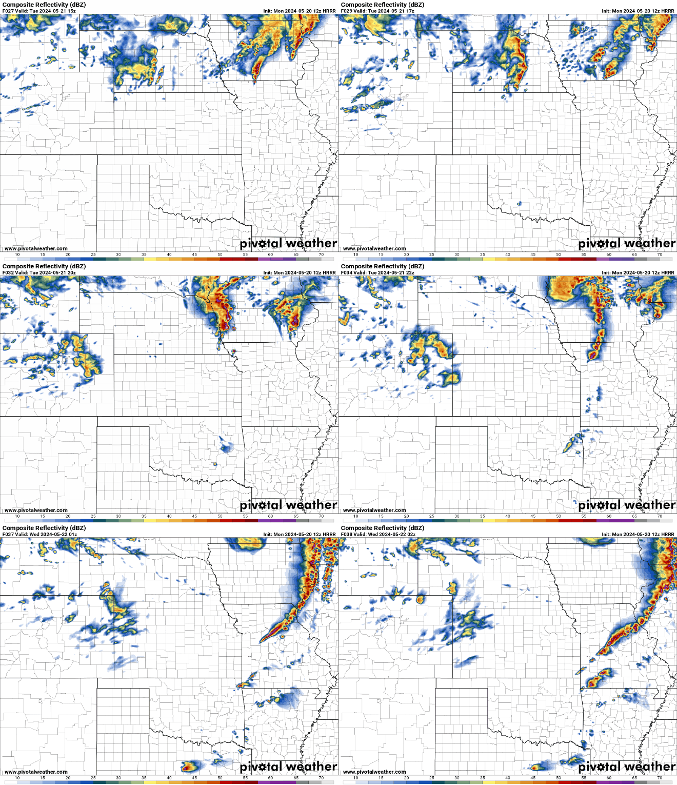
Simulated radar based on the 12z HRRR starting around 10 AM (showing potential supercell moving through locally in the early afternoon)...