2024 Weather Thread
-
Busguy2010

- City Council
- Posts: 7325
- Joined: Sat Apr 09, 2011 7:32 pm
- Location: North Central Omaha
Re: 2024 Weather Thread
I made it later than I thought. Lots of gustnado signatures on that leading edge as the tornado sirens just turned off. Buckle up.
-
stormchaser

- Planning Board
- Posts: 2380
- Joined: Fri Jun 01, 2018 8:14 am
Re: 2024 Weather Thread
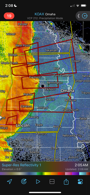
Be safe everyone, multiple tornado warnings along this line of damaging wind moving into Omaha.
-
skinzfan23

- City Council
- Posts: 11628
- Joined: Mon Feb 09, 2004 11:26 am
- Location: Omaha/Bellevue
Re: 2024 Weather Thread
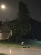
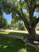
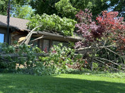
I was getting pretty scared near LaPlatte, sw of Offutt. The winds were definitely strong. Brought back memories of 2017.
My neighbors tree:
My neighbors tree:
-
stormchaser
- Planning Board
- Posts: 2380
- Joined: Fri Jun 01, 2018 8:14 am
Re: 2024 Weather Thread
Noticed some downed branches around town on my way to work but where I was at anyway, the winds didn't end up being all that bad. I'm not sure it hit above 50 mph at my house in Millard but I know other places were hit harder.
-
stormchaser
- Planning Board
- Posts: 2380
- Joined: Fri Jun 01, 2018 8:14 am
Re: 2024 Weather Thread
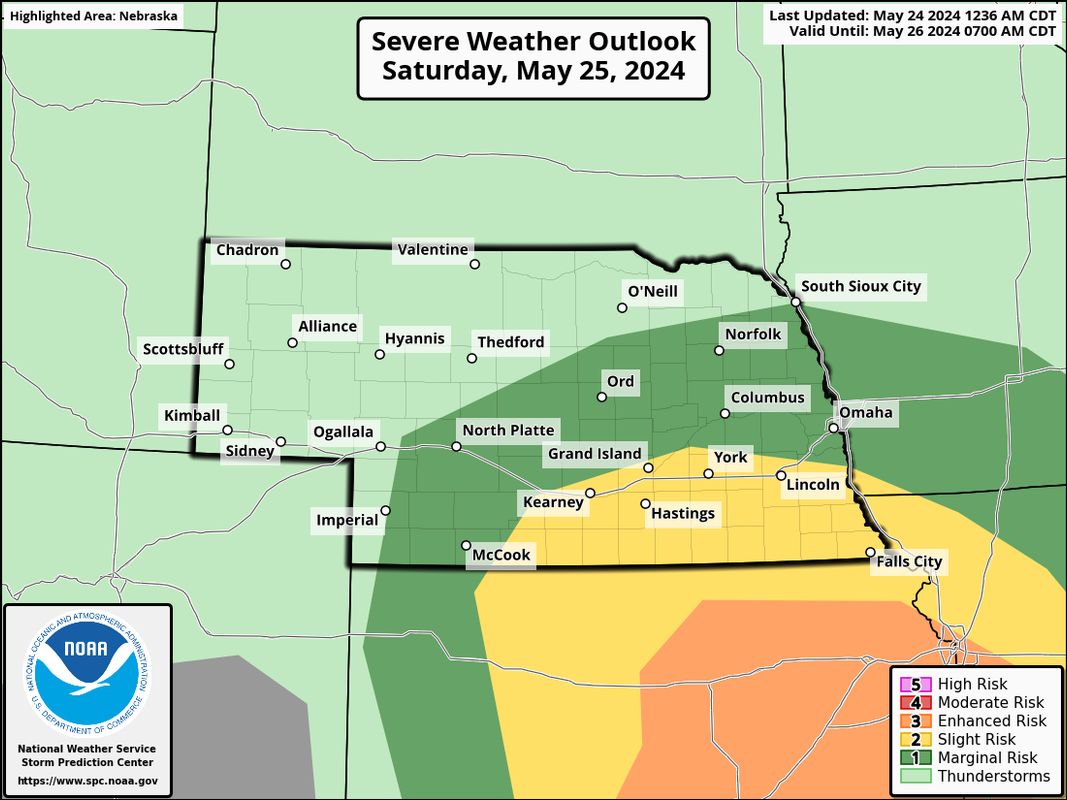
Still looking like the main severe threat tomorrow will stay south of Omaha (and mostly along the NE/KS border on south) where more strong tornadoes could occur in parts of KS/OK.
In Omaha itself, we may get a few isolated strong/severe storms but in general the risk is low and the main threat would probably be hail. Otherwise our main risk will be the potential for areas of heavy rain - especially if you happen to get one of the scattered storms that'll move through the area but that risk is higher into IA.
In Omaha itself, we may get a few isolated strong/severe storms but in general the risk is low and the main threat would probably be hail. Otherwise our main risk will be the potential for areas of heavy rain - especially if you happen to get one of the scattered storms that'll move through the area but that risk is higher into IA.
-
Busguy2010
- City Council
- Posts: 7325
- Joined: Sat Apr 09, 2011 7:32 pm
- Location: North Central Omaha
Re: 2024 Weather Thread
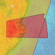
This was the most impressive gustnado signature in the area last night, though there were several others along the front. This one was on the south end of town, pretty much along the Platteview Road corridor as far as I could tell. Somebody I know in Gretna had a pretty mature tree knocked over. I believe this was a weak gust front tornado.
All in all, it wasn't bad in my neck of the woods. Maybe 50mph winds, and I ended up falling asleep once the initial front went through. Not too bad.
All in all, it wasn't bad in my neck of the woods. Maybe 50mph winds, and I ended up falling asleep once the initial front went through. Not too bad.
-
Busguy2010
- City Council
- Posts: 7325
- Joined: Sat Apr 09, 2011 7:32 pm
- Location: North Central Omaha
Re: 2024 Weather Thread
Also, after last night, were officially at 10.22". I forget what the record is, but we're climbing right on up the ladder.
-
stormchaser
- Planning Board
- Posts: 2380
- Joined: Fri Jun 01, 2018 8:14 am
Re: 2024 Weather Thread
Just to clarify, I know what you mean when you're saying "gustnado" - a tornado along a line of thunderstorms. However, just to avoid confusion with people who may see this - technically a "gustnado" is a non-tornadic feature typically caused by outflow from a wind-producing storm that kicks up dirt/dust and can rotate (fairly slowly usually) but is not connected to a storm and consequently isn't tornadic. They are frequently mistakenly reported by people as tornadoes because to the untrained eye, they see dirt spinning near a storm an immediately assume it's a tornado.Busguy2010 wrote: Fri May 24, 2024 11:38 am This was the most impressive gustnado signature in the area last night, though there were several others along the front. This one was on the south end of town, pretty much along the Platteview Road corridor as far as I could tell. Somebody I know in Gretna had a pretty mature tree knocked over. I believe this was a weak gust front tornado.
All in all, it wasn't bad in my neck of the woods. Maybe 50mph winds, and I ended up falling asleep once the initial front went through. Not too bad.
That isn't to say the tornado warnings last night weren't justified, they were with a meso/hook being depicted on radar. They just aren't technically gustnados though.

Last edited by stormchaser on Fri May 24, 2024 11:58 am, edited 1 time in total.
-
skinzfan23
- City Council
- Posts: 11628
- Joined: Mon Feb 09, 2004 11:26 am
- Location: Omaha/Bellevue
Re: 2024 Weather Thread
Yes, that is the part of the storm that I was concerned by. We live right off of Platteview Rd. The 2017 storm hit our area pretty hard and I was worried it was going to happen all over again. I saw on Jim Flowers' page it showed 86.1 mph but I don't know if that is the speed at the ground or not for the radar.Busguy2010 wrote: Fri May 24, 2024 11:38 am This was the most impressive gustnado signature in the area last night, though there were several others along the front. This one was on the south end of town, pretty much along the Platteview Road corridor as far as I could tell. Somebody I know in Gretna had a pretty mature tree knocked over. I believe this was a weak gust front tornado.
All in all, it wasn't bad in my neck of the woods. Maybe 50mph winds, and I ended up falling asleep once the initial front went through. Not too bad.
Either way, I am surprised that there is very little damage in our neighborhood with how strong the wind seemed to be. My neighbor's tree I posted above seems about the worst. I am sure that being a newer neighborhood without all the established trees and buried power lines helped.
-
Louie
- County Board
- Posts: 4935
- Joined: Fri Dec 23, 2011 4:23 pm
- Location: Dundee
Re: 2024 Weather Thread
Into 4th, but only .11 from 3rd.Busguy2010 wrote: Fri May 24, 2024 11:41 am Also, after last night, were officially at 10.22". I forget what the record is, but we're climbing right on up the ladder.
-
Brad

- Photographer
- Posts: 1036552
- Joined: Sat Feb 28, 2004 6:03 pm
- Location: Omaha, NE
Re: 2024 Weather Thread
I saw on wowt that the NWS is classifying this line as a "derecho".
https://www.wowt.com/2024/05/24/friday- ... aha-metro/
https://www.wowt.com/2024/05/24/friday- ... aha-metro/
wowt.com wrote:The National Weather Service declared the storms that hit the area early Friday morning a derecho. The line of storms started in Nebraska then blew all across Iowa and into Illinois.
The highest wind gust reported so far in the Omaha-metro area was 82 mph in Papillion at 2:41am.

Omaha Skyline Photos, Omaha Aerial Photos, and More.
Website: www.bradwilliamsphotography.com
Facebook: www.facebook.com/bradwilliamsphotography
Twitter: www.twitter.com/bradwphoto
Instagram: www.instagram.com/bradwilliamsphotography
YouTube: www.youtube.com/@bradwilliamsphoto
-
Coyote

- City Council
- Posts: 34366
- Joined: Tue Nov 18, 2003 11:18 am
- Location: Aksarben Village
Re: 2024 Weather Thread
Headline News - Nebraska May 24th, 2024
Record Breaking WEATHER 18 Tornados
Top stories across Nebraska and the Nation.
Record Breaking WEATHER 18 Tornados
Top stories across Nebraska and the Nation.
-
Busguy2010
- City Council
- Posts: 7325
- Joined: Sat Apr 09, 2011 7:32 pm
- Location: North Central Omaha
Re: 2024 Weather Thread
It definitely was reminiscent of that 2017 storm with the location and type of tornado. Luckily not as bad though. I wonder if they'll even be classified as tornadoes or even surveyed. There was a bunch of spinups along the line, this one was just the most impressive.skinzfan23 wrote: Fri May 24, 2024 11:54 am The 2017 storm hit our area pretty hard and I was worried it was going to happen all over again.
-
Coyote
- City Council
- Posts: 34366
- Joined: Tue Nov 18, 2003 11:18 am
- Location: Aksarben Village
Re: 2024 Weather Thread
Derecho hits Washington County, causing power outages, damaging sidewalks, and uprooting treesBrad wrote: Fri May 24, 2024 3:44 pm I saw on wowt that the NWS is classifying this line as a "derecho".
The National Weather Service said Friday's early morning storms do meet derecho qualifications, and Washington County was one of the hardest hit areas.
-
nativeomahan

- County Board
- Posts: 6013
- Joined: Fri Nov 12, 2004 2:46 pm
- Location: Omaha and Puerto Vallarta
Re: 2024 Weather Thread
This has been a tough week for many in Eastern Nebraska on into Iowa. If it wasn’t the flooding rains destroying property it was the winds. Fortunately our property had minimal water damage and no wind damage. But my neighbors just a block away had lots of both.
And talk about a weather whiplash, May 2023 saw virtually no rain, making it the driest on record. This May still has about 1 week left and it is already the all time wettest May on record.

And talk about a weather whiplash, May 2023 saw virtually no rain, making it the driest on record. This May still has about 1 week left and it is already the all time wettest May on record.
-
stormchaser
- Planning Board
- Posts: 2380
- Joined: Fri Jun 01, 2018 8:14 am
Re: 2024 Weather Thread
Unfortunately some areas of heavy rain moving back into the area tonight with scattered strong/severe storms and at least some areas getting 1-2”+ of rain (though not everyone will see that much).
-
stormchaser
- Planning Board
- Posts: 2380
- Joined: Fri Jun 01, 2018 8:14 am
Re: 2024 Weather Thread
Thankfully all the rain stayed just north or just south of us last night.
Lots of branches down though around Millard - I’m assuming from outflow that pushed through even though the rain missed us.
Lots of branches down though around Millard - I’m assuming from outflow that pushed through even though the rain missed us.
-
Louie
- County Board
- Posts: 4935
- Joined: Fri Dec 23, 2011 4:23 pm
- Location: Dundee
Re: 2024 Weather Thread
Did you get any rain in your part of town?stormchaser wrote: Sun May 26, 2024 5:43 am Thankfully all the rain stayed just north or just south of us last night.
Lots of branches down though around Millard - I’m assuming from outflow that pushed through even though the rain missed us.
-
Brad
- Photographer
- Posts: 1036552
- Joined: Sat Feb 28, 2004 6:03 pm
- Location: Omaha, NE
Re: 2024 Weather Thread
That wind was crazy. For a non-severe storm wind, it left more debris around my neighborhood than any of the other storms.stormchaser wrote: Sun May 26, 2024 5:43 am Thankfully all the rain stayed just north or just south of us last night.
Lots of branches down though around Millard - I’m assuming from outflow that pushed through even though the rain missed us.
Omaha Skyline Photos, Omaha Aerial Photos, and More.
Website: www.bradwilliamsphotography.com
Facebook: www.facebook.com/bradwilliamsphotography
Twitter: www.twitter.com/bradwphoto
Instagram: www.instagram.com/bradwilliamsphotography
YouTube: www.youtube.com/@bradwilliamsphoto
-
stormchaser
- Planning Board
- Posts: 2380
- Joined: Fri Jun 01, 2018 8:14 am
Re: 2024 Weather Thread
Not a drop…or at least nothing measurable.
-
skinzfan23
- City Council
- Posts: 11628
- Joined: Mon Feb 09, 2004 11:26 am
- Location: Omaha/Bellevue
Re: 2024 Weather Thread
In south Bellevue it rained really hard for maybe 20-30 min and continued to rain for a hr or two but I didn’t check the amount.
-
stormchaser
- Planning Board
- Posts: 2380
- Joined: Fri Jun 01, 2018 8:14 am
Re: 2024 Weather Thread
I realize this isn’t from our area (it’s from a truck stop in Valley View, TX from Saturday night) but I’m posting it to show how insane and terrifying things can QUICKLY get - hence needing to pay attention to and take action when warnings are issued. Especially at night as you may not see the tornado until it’s almost too late.
This footage is from a storm chaser who had to take shelter at this truck stop to try to survive the storm.
Luckily everyone in the truck stop survived though a mass casualty event and several deaths unfortunately occurred in that area.
Terrifying stuff.
This footage is from a storm chaser who had to take shelter at this truck stop to try to survive the storm.
Luckily everyone in the truck stop survived though a mass casualty event and several deaths unfortunately occurred in that area.
Terrifying stuff.
-
Busguy2010
- City Council
- Posts: 7325
- Joined: Sat Apr 09, 2011 7:32 pm
- Location: North Central Omaha
Re: 2024 Weather Thread
It's official: The NWS declared 12 tornadoes along the derecho front, including of course, the one that was in Sarpy County, as well as the many others we screenshotted on radar here.
-
skinzfan23
- City Council
- Posts: 11628
- Joined: Mon Feb 09, 2004 11:26 am
- Location: Omaha/Bellevue

-
Louie
- County Board
- Posts: 4935
- Joined: Fri Dec 23, 2011 4:23 pm
- Location: Dundee
Re: 2024 Weather Thread
With chances of rain Thursday and into Friday, this will be a buzzer beater if it gets there.
-
stormchaser
- Planning Board
- Posts: 2380
- Joined: Fri Jun 01, 2018 8:14 am
Re: 2024 Weather Thread
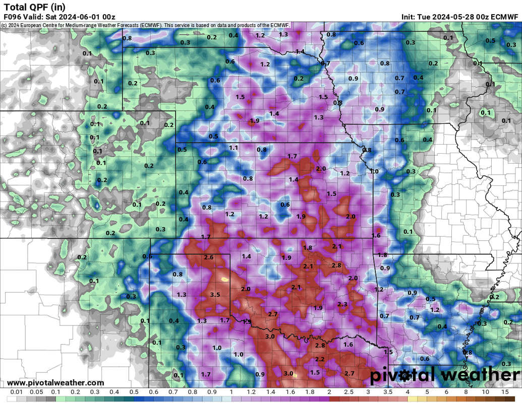
Decent chance will get there but who knows. Based on 00z ECMWF, we will maybe break it relatively easily or we might not get there depending on exactly where the heavier rain ends up...Louie wrote: Tue May 28, 2024 8:51 am With chances of rain Thursday and into Friday, this will be a buzzer beater if it gets there.
Depicted rain totals between now and the end of the month:
-
Cermak
- Planning Board
- Posts: 2330
- Joined: Thu Nov 29, 2018 1:02 pm
Re: 2024 Weather Thread
Today looks like a potential top 10 weather day. Tuesday evening was spectacular.
-
skinzfan23
- City Council
- Posts: 11628
- Joined: Mon Feb 09, 2004 11:26 am
- Location: Omaha/Bellevue
Re: 2024 Weather Thread
Excited for the nice day. Going to put our above ground pool up tonight and the lighter winds definitely help. With the warm and humid weather coming up, it will be the perfect time.
-
nativeomahan
- County Board
- Posts: 6013
- Joined: Fri Nov 12, 2004 2:46 pm
- Location: Omaha and Puerto Vallarta
Re: 2024 Weather Thread
Absolutely. We enjoyed dinner on the patio last night and both of us remarked how it could not have been a nicer evening. Today was also simply spectacular.Cermak wrote: Wed May 29, 2024 4:45 am Today looks like a potential top 10 weather day. Tuesday evening was spectacular.
-
Brad
- Photographer
- Posts: 1036552
- Joined: Sat Feb 28, 2004 6:03 pm
- Location: Omaha, NE
Re: 2024 Weather Thread
Today is perfect. I photographed 5 properties for myself and 2 projects for the “real job”. Wish every day was like this…
Omaha Skyline Photos, Omaha Aerial Photos, and More.
Website: www.bradwilliamsphotography.com
Facebook: www.facebook.com/bradwilliamsphotography
Twitter: www.twitter.com/bradwphoto
Instagram: www.instagram.com/bradwilliamsphotography
YouTube: www.youtube.com/@bradwilliamsphoto
-
Louie
- County Board
- Posts: 4935
- Joined: Fri Dec 23, 2011 4:23 pm
- Location: Dundee
Re: 2024 Weather Thread
Bet you got perfect lighting and perfect foliage for it.Brad wrote: Wed May 29, 2024 6:46 pm Today is perfect. I photographed 5 properties for myself and 2 projects for the “real job”. Wish every day was like this…
-
Brad
- Photographer
- Posts: 1036552
- Joined: Sat Feb 28, 2004 6:03 pm
- Location: Omaha, NE
Re: 2024 Weather Thread
Yep, everything is so nice and green right now!
Omaha Skyline Photos, Omaha Aerial Photos, and More.
Website: www.bradwilliamsphotography.com
Facebook: www.facebook.com/bradwilliamsphotography
Twitter: www.twitter.com/bradwphoto
Instagram: www.instagram.com/bradwilliamsphotography
YouTube: www.youtube.com/@bradwilliamsphoto
-
thenewguy
- County Board
- Posts: 4329
- Joined: Fri Oct 19, 2007 9:50 pm
- Location: Council Bluffs
Re: 2024 Weather Thread
were you up in a helicopter yesterday? I saw one flying around downtown/by the river, wondered if that was you
Go Cubs Go
-
Brad
- Photographer
- Posts: 1036552
- Joined: Sat Feb 28, 2004 6:03 pm
- Location: Omaha, NE
Re: 2024 Weather Thread
No, I wish!
Omaha Skyline Photos, Omaha Aerial Photos, and More.
Website: www.bradwilliamsphotography.com
Facebook: www.facebook.com/bradwilliamsphotography
Twitter: www.twitter.com/bradwphoto
Instagram: www.instagram.com/bradwilliamsphotography
YouTube: www.youtube.com/@bradwilliamsphoto
-
Cermak
- Planning Board
- Posts: 2330
- Joined: Thu Nov 29, 2018 1:02 pm
Re: 2024 Weather Thread
I’m up in NW Omaha approximately 100th st and West Maple around 4pm . They are getting dumped on up here easily a couple inches at least, some minor street flooding.
-
stormchaser
- Planning Board
- Posts: 2380
- Joined: Fri Jun 01, 2018 8:14 am
Re: 2024 Weather Thread
Yeah much of western Omaha radar estimates of 1"-2"...but we will see what Eppley ends up getting to see if we actually break the record.
Should be extremely close if we don't.
Should be extremely close if we don't.
-
stormchaser
- Planning Board
- Posts: 2380
- Joined: Fri Jun 01, 2018 8:14 am
Re: 2024 Weather Thread
Severe weather potential returns to the area this coming Sunday and Tuesday.
Sunday all modes of severe storms will be possible including supercells and tornadoes. Tuesday currently looks more linear and primarily a damaging wind threat.
These are both based on the 12z ECMWF so plenty of uncertainty and time for things to change. That said, don’t be surprised if the SPC starts including parts of the area in upcoming outlooks.
Sunday all modes of severe storms will be possible including supercells and tornadoes. Tuesday currently looks more linear and primarily a damaging wind threat.
These are both based on the 12z ECMWF so plenty of uncertainty and time for things to change. That said, don’t be surprised if the SPC starts including parts of the area in upcoming outlooks.
-
stormchaser
- Planning Board
- Posts: 2380
- Joined: Fri Jun 01, 2018 8:14 am
Re: 2024 Weather Thread
Now that things have slowed down (until possibly Sunday anyway), I’d like to offer a better explanation about gustnados.
To clarify, please don’t take this as criticism or anything negative towards anyone at all. My intentions are 100% to just inform/help which has been and always will be my intention with posting here. I also want to stress I’m not trying to come across as a “know it all”. Trust me, there are TONS of things I don’t know/understand and I’m always trying to learn more and my forecasts are completely wrong plenty of times.
What happened in Omaha ~a week ago is what’s known as QLCS (Quasi-Linear Convective System) - aka squall line or arguably a line of storms with embedded supercells - eventually classified as a derecho since it caused widespread wind damage, especially north of Omaha and into Iowa. These storms DID produce confirmed tornadoes in our area (as I had indicated there was potential for due to the strong low level jet). Like normal with these types of tornadoes, they were very weak/brief though (EF0 in this case).
However, just to stress my point here, they are not “gustnados” (though I understand the confusion since they form along the leading edge of the storms) - often referred to as a “gust front”.
As I attempted to indicate in a previous post, a “gustnado” is non-tornadic. The circulation formed at the surface has no direct connection (aka meso or funnel) to the base of a storm - hence why it isn’t classified as a tornado. For reference, the official definition can be found here: https://forecast.weather.gov/glossary.php?word=gustnado.
So yes, what Busguy2010 (and others I believe) screenshotted was 100% correct and was tornadic, referring to them as a gustnado in this case is incorrect. They would simply be classified as tornadoes.
Also, I apologize for posting this again. I’m not trying to beat a dead horse here. i just re-read my reply that I made the other day and realized it wasn’t very clear in what I was trying to get across so I’m attempting to do a better job.
It’s important that people understand the difference in case anyone makes or reads reports and sees “gustnado”. ;)
To clarify, please don’t take this as criticism or anything negative towards anyone at all. My intentions are 100% to just inform/help which has been and always will be my intention with posting here. I also want to stress I’m not trying to come across as a “know it all”. Trust me, there are TONS of things I don’t know/understand and I’m always trying to learn more and my forecasts are completely wrong plenty of times.
What happened in Omaha ~a week ago is what’s known as QLCS (Quasi-Linear Convective System) - aka squall line or arguably a line of storms with embedded supercells - eventually classified as a derecho since it caused widespread wind damage, especially north of Omaha and into Iowa. These storms DID produce confirmed tornadoes in our area (as I had indicated there was potential for due to the strong low level jet). Like normal with these types of tornadoes, they were very weak/brief though (EF0 in this case).
However, just to stress my point here, they are not “gustnados” (though I understand the confusion since they form along the leading edge of the storms) - often referred to as a “gust front”.
As I attempted to indicate in a previous post, a “gustnado” is non-tornadic. The circulation formed at the surface has no direct connection (aka meso or funnel) to the base of a storm - hence why it isn’t classified as a tornado. For reference, the official definition can be found here: https://forecast.weather.gov/glossary.php?word=gustnado.
So yes, what Busguy2010 (and others I believe) screenshotted was 100% correct and was tornadic, referring to them as a gustnado in this case is incorrect. They would simply be classified as tornadoes.
Also, I apologize for posting this again. I’m not trying to beat a dead horse here. i just re-read my reply that I made the other day and realized it wasn’t very clear in what I was trying to get across so I’m attempting to do a better job.
It’s important that people understand the difference in case anyone makes or reads reports and sees “gustnado”. ;)
Last edited by stormchaser on Thu May 30, 2024 7:52 pm, edited 4 times in total.
-
Brad
- Photographer
- Posts: 1036552
- Joined: Sat Feb 28, 2004 6:03 pm
- Location: Omaha, NE
Re: 2024 Weather Thread
As of 7pm, Eppley was only at 0.23" of rain...stormchaser wrote: Thu May 30, 2024 4:45 pm Yeah much of western Omaha radar estimates of 1"-2"...but we will see what Eppley ends up getting to see if we actually break the record.
Should be extremely close if we don't.
My math says that 10.92" as of 7pm tonight.
Omaha Skyline Photos, Omaha Aerial Photos, and More.
Website: www.bradwilliamsphotography.com
Facebook: www.facebook.com/bradwilliamsphotography
Twitter: www.twitter.com/bradwphoto
Instagram: www.instagram.com/bradwilliamsphotography
YouTube: www.youtube.com/@bradwilliamsphoto
-
stormchaser
- Planning Board
- Posts: 2380
- Joined: Fri Jun 01, 2018 8:14 am
Re: 2024 Weather Thread
I wondered, the storms were starting to fall apart some as they pushed more into that area…Brad wrote: Thu May 30, 2024 7:46 pmAs of 7pm, Eppley was only at 0.23" of rain...stormchaser wrote: Thu May 30, 2024 4:45 pm Yeah much of western Omaha radar estimates of 1"-2"...but we will see what Eppley ends up getting to see if we actually break the record.
Should be extremely close if we don't.
My math says that 10.92" as of 7pm tonight.