2024 Weather Thread
-
nebugeater

- City Council
- Posts: 110947
- Joined: Wed Aug 04, 2004 6:07 pm
- Location: Gretna NE
Re: 2024 Weather Thread
I heard there was 7" over night near the Millard Airport
For the record NEBUGEATER does not equal BUGEATER !!!!!!!
-
skinzfan23

- City Council
- Posts: 11628
- Joined: Mon Feb 09, 2004 11:26 am
- Location: Omaha/Bellevue
Re: 2024 Weather Thread
Wow, thats crazy, thankfully the river levels only went up slightly and are now headed back down.
-
zippy
- Library Board
- Posts: 301
- Joined: Wed Mar 09, 2005 5:55 pm
- Location: Harvey Oaks
Re: 2024 Weather Thread
Out by Oakview Mall/Heartwood, we got 1.1" in the morning, and over 5" last night (rain gauge overflowed).
-
BRoss

- IT Director
- Posts: 10003376
- Joined: Fri Aug 04, 2006 7:39 pm
- Location: West Central Omaha
Re: 2024 Weather Thread
Wow, you got the normal whole months worth on the first day. I got 2.97".skinzfan23 wrote: Tue Jul 02, 2024 8:02 am Wow, just checked my rain gauge from last night....3.7" on top of the .4" yesterday morning.
-
BRoss
- IT Director
- Posts: 10003376
- Joined: Fri Aug 04, 2006 7:39 pm
- Location: West Central Omaha
Re: 2024 Weather Thread
Found one weather station reporting 6" while quickly checking. Crazy!
-
stormchaser

- Planning Board
- Posts: 2380
- Joined: Fri Jun 01, 2018 8:14 am
Re: 2024 Weather Thread
We aren't done yet either (especially on the west side of the metro) with more moving in from the southwest. At least most of the severe threat today should stay east/southeast of here.
Radar as of ~ 10 AM:
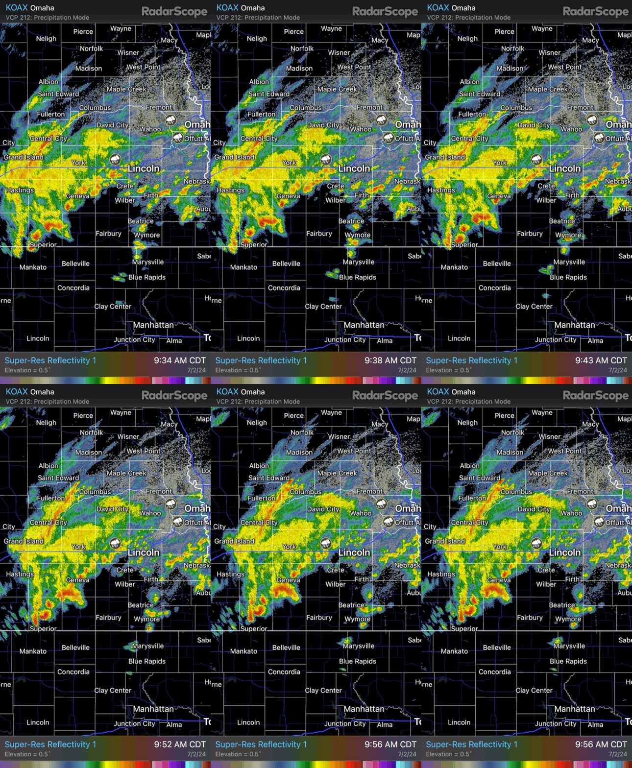
Radar as of ~ 10 AM:
-
EastCB
- Library Board
- Posts: 383
- Joined: Thu Oct 05, 2006 11:30 am
- Location: Council Bluffs
Re: 2024 Weather Thread
My gauge said 6.25 this morning.
-
skinzfan23
- City Council
- Posts: 11628
- Joined: Mon Feb 09, 2004 11:26 am
- Location: Omaha/Bellevue
Re: 2024 Weather Thread
Not about Omaha, but we are supposed to head to Jamaica on Monday.....of course Cat 5 hurricane is headed straight for the island. Thankful that we aren't there right now, but watching closely to see if we are still able to go.
-
stormchaser
- Planning Board
- Posts: 2380
- Joined: Fri Jun 01, 2018 8:14 am
Re: 2024 Weather Thread
Yeah, definitely good you aren't there currently at least. What a beast of a storm...skinzfan23 wrote: Tue Jul 02, 2024 11:57 am Not about Omaha, but we are supposed to head to Jamaica on Monday.....of course Cat 5 hurricane is headed straight for the island. Thankful that we aren't there right now, but watching closely to see if we are still able to go.
-
stormchaser
- Planning Board
- Posts: 2380
- Joined: Fri Jun 01, 2018 8:14 am
Re: 2024 Weather Thread
A supercell is trying to develop just east of Council Bluffs currently. Wouldn't be surprised to see a tornado warning issued in the near future on it IF it can continue (though there are alot of other storms around so hard to say if this one will become dominant or not). Definitely trying though...
That said, there is a better chance for tornadic storms further east and south. Right now around Creston, IA seems like the place to be (or not be) as storms area really starting to fire.
That said, there is a better chance for tornadic storms further east and south. Right now around Creston, IA seems like the place to be (or not be) as storms area really starting to fire.
-
skinzfan23
- City Council
- Posts: 11628
- Joined: Mon Feb 09, 2004 11:26 am
- Location: Omaha/Bellevue
Re: 2024 Weather Thread
Pretty impressive. They ended up with a Cat 4 storm, and although it didn't make landfall, it still was a pretty intense storm. Less than 24 hrs later, most of the resorts are already back open (running on generators) and the airport is now open too.stormchaser wrote: Tue Jul 02, 2024 1:14 pmYeah, definitely good you aren't there currently at least. What a beast of a storm...skinzfan23 wrote: Tue Jul 02, 2024 11:57 am Not about Omaha, but we are supposed to head to Jamaica on Monday.....of course Cat 5 hurricane is headed straight for the island. Thankful that we aren't there right now, but watching closely to see if we are still able to go.
-
Busguy2010

- City Council
- Posts: 7325
- Joined: Sat Apr 09, 2011 7:32 pm
- Location: North Central Omaha
Re: 2024 Weather Thread
Looks like we're supposed to get a decent shot of heavy rain tonight around 6-8. But the thing I really have my eye on is the big cool down that's forecast. Below 70 by 10pm, so I'll definitely be letting the free AC in tonight.
-
stormchaser
- Planning Board
- Posts: 2380
- Joined: Fri Jun 01, 2018 8:14 am
Re: 2024 Weather Thread
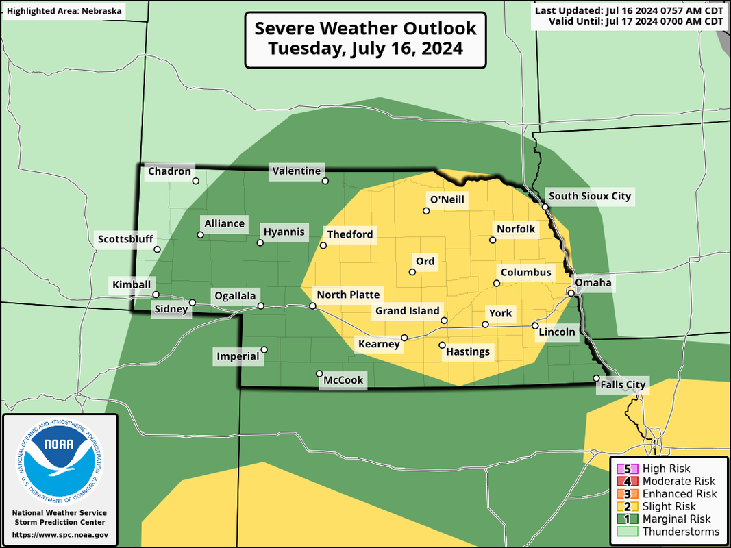
There is a chance for severe weather in much of eastern NE today. Mostly a threat for damaging wind/hail though an isolated tornado or 2 can't be ruled out. The threat is higher west/northwest of Omaha today.
-
almighty_tuna
- City Council
- Posts: 106374
- Joined: Tue Apr 13, 2004 1:34 pm
- Location: Somewhere between downtown and Colorado
Re: 2024 Weather Thread

I picked a helluva day to go camping in eastern NE!
-
Cermak
- Planning Board
- Posts: 2330
- Joined: Thu Nov 29, 2018 1:02 pm
Re: 2024 Weather Thread
Just found out Des Moines specifically Urbandale had a tornado yesterday. Mainly roof and tree damage. Not on the scale of the one that hit Elkhorn and Bennington this April. But still surprised, since we had nothing in Omaha except extreme heat. These storms eventually moved on to the Chicago area.
-
Brad

- Photographer
- Posts: 1036552
- Joined: Sat Feb 28, 2004 6:03 pm
- Location: Omaha, NE
Re: 2024 Weather Thread
Luckily they didn't have more damage because the photos I saw made it look like a big tornado. Most of the storms yesterday all fired up in Western Iowa and slide east/south east. The line made it a lot further than Chicago. When I went to bed last night it was in to central Indiana.Cermak wrote: Tue Jul 16, 2024 10:42 am Just found out Des Moines specifically Urbandale had a tornado yesterday. Mainly roof and tree damage. Not on the scale of the one that hit Elkhorn and Bennington this April. But still surprised, since we had nothing in Omaha except extreme heat. These storms eventually moved on to the Chicago area.
There was severe weather as close as Dennison and Carrol yesterday. A tornado warning by Red Oak too.

Omaha Skyline Photos, Omaha Aerial Photos, and More.
Website: www.bradwilliamsphotography.com
Facebook: www.facebook.com/bradwilliamsphotography
Twitter: www.twitter.com/bradwphoto
Instagram: www.instagram.com/bradwilliamsphotography
YouTube: www.youtube.com/@bradwilliamsphoto
-
Brad
- Photographer
- Posts: 1036552
- Joined: Sat Feb 28, 2004 6:03 pm
- Location: Omaha, NE
Re: 2024 Weather Thread
Looks like it broke apart in Indiana. Here is a cool time-lapse of it!Brad wrote: Tue Jul 16, 2024 10:53 amLuckily they didn't have more damage because the photos I saw made it look like a big tornado. Most of the storms yesterday all fired up in Western Iowa and slide east/south east. The line made it a lot further than Chicago. When I went to bed last night it was in to central Indiana.Cermak wrote: Tue Jul 16, 2024 10:42 am Just found out Des Moines specifically Urbandale had a tornado yesterday. Mainly roof and tree damage. Not on the scale of the one that hit Elkhorn and Bennington this April. But still surprised, since we had nothing in Omaha except extreme heat. These storms eventually moved on to the Chicago area.
There was severe weather as close as Dennison and Carrol yesterday. A tornado warning by Red Oak too.
Omaha Skyline Photos, Omaha Aerial Photos, and More.
Website: www.bradwilliamsphotography.com
Facebook: www.facebook.com/bradwilliamsphotography
Twitter: www.twitter.com/bradwphoto
Instagram: www.instagram.com/bradwilliamsphotography
YouTube: www.youtube.com/@bradwilliamsphoto
-
Louie
- County Board
- Posts: 4935
- Joined: Fri Dec 23, 2011 4:23 pm
- Location: Dundee
Re: 2024 Weather Thread
Wow, that was an impressive fire up.
-
skinzfan23
- City Council
- Posts: 11628
- Joined: Mon Feb 09, 2004 11:26 am
- Location: Omaha/Bellevue
Re: 2024 Weather Thread
I know some of our relatives in eastern Iowa got some strong winds, lots of lightning and heavy rain, but nothing too major.
I am glad that the Omaha area has all the reservoirs that we do, I am pretty sure that Cedar Rapids/Marion, IA specifically couldn't handle the amount of rain we had a few weeks ago. I know parts of Papillion had 6-8 in of rain within a 24 hr period. In eastern IA they got 2-3" and had quite a bit of street flooding, however, they don't have the extensive system that Omaha does.
I am glad that the Omaha area has all the reservoirs that we do, I am pretty sure that Cedar Rapids/Marion, IA specifically couldn't handle the amount of rain we had a few weeks ago. I know parts of Papillion had 6-8 in of rain within a 24 hr period. In eastern IA they got 2-3" and had quite a bit of street flooding, however, they don't have the extensive system that Omaha does.
-
Brad
- Photographer
- Posts: 1036552
- Joined: Sat Feb 28, 2004 6:03 pm
- Location: Omaha, NE
Re: 2024 Weather Thread
This is hilarious... Hits way too close to home! LOL
Omaha Skyline Photos, Omaha Aerial Photos, and More.
Website: www.bradwilliamsphotography.com
Facebook: www.facebook.com/bradwilliamsphotography
Twitter: www.twitter.com/bradwphoto
Instagram: www.instagram.com/bradwilliamsphotography
YouTube: www.youtube.com/@bradwilliamsphoto
-
nebugeater
- City Council
- Posts: 110947
- Joined: Wed Aug 04, 2004 6:07 pm
- Location: Gretna NE
-
stormchaser
- Planning Board
- Posts: 2380
- Joined: Fri Jun 01, 2018 8:14 am
Re: 2024 Weather Thread
That's amazing!
-
Cermak
- Planning Board
- Posts: 2330
- Joined: Thu Nov 29, 2018 1:02 pm
Re: 2024 Weather Thread
Supposed to have a high of just 73 this Saturday. For this time of year that’s almost unheard of. Looks like some rain as well, we could use a little rain.
-
skinzfan23
- City Council
- Posts: 11628
- Joined: Mon Feb 09, 2004 11:26 am
- Location: Omaha/Bellevue
Re: 2024 Weather Thread
Although, we have had quite a bit of rain this year, it really has come in spurts, so although it looks like we have plenty, the ground is drying out quickly. So as mentioned above, rainfall will be welcome.
-
Brad
- Photographer
- Posts: 1036552
- Joined: Sat Feb 28, 2004 6:03 pm
- Location: Omaha, NE
Re: 2024 Weather Thread
For those of you interested in the science behind the storms, there is a great video for you.
Meteorological Breakdown: Prolific Tornado Outbreak Ravages Nebraska and Iowa - April 26, 2024
Meteorological Breakdown: Prolific Tornado Outbreak Ravages Nebraska and Iowa - April 26, 2024
Convective Chronicles wrote: Jul 17, 2024
In-depth meteorological breakdown of the prolific tornado outbreak centered on eastern Nebraska and western Iowa back on April 26, 2024. This has been the most prolific outbreak of the year so far with nearly 150 tornado reports in total from Nebraska/Iowa down to Texas. Multiple supercells produced numerous intense, long-track tornadoes, including ones that impacted parts of Lincoln and Omaha, NE. In this video, we'll take a deep dive into the meteorology behind the April 26 outbreak, going storm by storm in an attempt to determine why this event was such an efficient tornado producer.
Omaha Skyline Photos, Omaha Aerial Photos, and More.
Website: www.bradwilliamsphotography.com
Facebook: www.facebook.com/bradwilliamsphotography
Twitter: www.twitter.com/bradwphoto
Instagram: www.instagram.com/bradwilliamsphotography
YouTube: www.youtube.com/@bradwilliamsphoto
-
stormchaser
- Planning Board
- Posts: 2380
- Joined: Fri Jun 01, 2018 8:14 am
Re: 2024 Weather Thread
Nice! I'll have to take a closer look when I have some free time.Brad wrote: Thu Jul 18, 2024 10:18 am For those of you interested in the science behind the storms, there is a great video for you.
Meteorological Breakdown: Prolific Tornado Outbreak Ravages Nebraska and Iowa - April 26, 2024
Convective Chronicles wrote: Jul 17, 2024
In-depth meteorological breakdown of the prolific tornado outbreak centered on eastern Nebraska and western Iowa back on April 26, 2024. This has been the most prolific outbreak of the year so far with nearly 150 tornado reports in total from Nebraska/Iowa down to Texas. Multiple supercells produced numerous intense, long-track tornadoes, including ones that impacted parts of Lincoln and Omaha, NE. In this video, we'll take a deep dive into the meteorology behind the April 26 outbreak, going storm by storm in an attempt to determine why this event was such an efficient tornado producer.
-
Busguy2010
- City Council
- Posts: 7325
- Joined: Sat Apr 09, 2011 7:32 pm
- Location: North Central Omaha
Re: 2024 Weather Thread
Ya know, I'd hate to jynx it, but with the days already visibly waning, meteorological summer almost 2/3's through, and the upcoming weekend looking like we'll have a hard time breaking 75, this summer has been surprisingly a cool one. Outside of a handful of miserable days, the overall climate has been exceptionally bearable. I can't recall a summer being this oddly comfortable... So far, as I knock on wood.
-
skinzfan23
- City Council
- Posts: 11628
- Joined: Mon Feb 09, 2004 11:26 am
- Location: Omaha/Bellevue
Re: 2024 Weather Thread
Nice good rain last night and for once this summer, no severe weather along with it.
-
Cermak
- Planning Board
- Posts: 2330
- Joined: Thu Nov 29, 2018 1:02 pm
Re: 2024 Weather Thread
A gradual warmup as we have a stretch of 90’s starting tomorrow. Im turning my air back on today as it’s been off since the middle of last week. I really enjoyed the break from the heat especially Friday thru Sunday. The weather will be dry as well, looks like the dog days of summer are here.
-
damonhynes

- Parks & Recreation
- Posts: 1278
- Joined: Tue Aug 26, 2014 7:35 pm
- Location: Montgomery County, Texas
Re: 2024 Weather Thread
I'm seeing on FB that some of my chaser friends who are more into the research aspects mention that the 4/26 Elkhorn tornado is now 'officially' an EF-4. I've been too busy to check the cites, and there's nothing on WFO OAX's page...
-
Brad
- Photographer
- Posts: 1036552
- Joined: Sat Feb 28, 2004 6:03 pm
- Location: Omaha, NE
Re: 2024 Weather Thread
I haven’t seen anything official, but I have seen the speculation too, like this tweet.damonhynes wrote: Sat Jul 27, 2024 11:45 am I'm seeing on FB that some of my chaser friends who are more into the research aspects mention that the 4/26 Elkhorn tornado is now 'officially' an EF-4. I've been too busy to check the cites, and there's nothing on WFO OAX's page...
Omaha Skyline Photos, Omaha Aerial Photos, and More.
Website: www.bradwilliamsphotography.com
Facebook: www.facebook.com/bradwilliamsphotography
Twitter: www.twitter.com/bradwphoto
Instagram: www.instagram.com/bradwilliamsphotography
YouTube: www.youtube.com/@bradwilliamsphoto
-
Busguy2010
- City Council
- Posts: 7325
- Joined: Sat Apr 09, 2011 7:32 pm
- Location: North Central Omaha
Re: 2024 Weather Thread
It certainly looked the part. I still can't stress enough, though what happened in Elkhorn was terrible, we dodged a huge bullet since that thing didn't hit a denser populated part of town. People who remember the 1975 tornado will also remember this one, and hopefully the last one of that caliber they'll see. So in my book, it was a once or twice in a lifetime tornado. 1913-1975-2024. The Elkhorn tornado was "the one", and we're so lucky it didn't hit the city directly. I hope we don't have to deal with another intense tornado like that for another 50-60 years.
-
stormchaser
- Planning Board
- Posts: 2380
- Joined: Fri Jun 01, 2018 8:14 am
Re: 2024 Weather Thread
The SPC has expanded a "slight risk" into the Lincoln Omaha area for later today and includes a risk for large hail, damaging wind and isolated tornadoes.
The severe weather threat today should be very scattered so most people will see nothing at all but don't be surprised to see some warnings in the area later today and this evening.
Latest outlook:
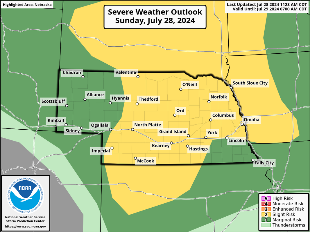
The severe weather threat today should be very scattered so most people will see nothing at all but don't be surprised to see some warnings in the area later today and this evening.
Latest outlook:
-
stormchaser
- Planning Board
- Posts: 2380
- Joined: Fri Jun 01, 2018 8:14 am
Re: 2024 Weather Thread
I'm not surprised - just hearing the roar/waterfall sound, you could tell it was a powerful tornado.damonhynes wrote: Sat Jul 27, 2024 11:45 am I'm seeing on FB that some of my chaser friends who are more into the research aspects mention that the 4/26 Elkhorn tornado is now 'officially' an EF-4. I've been too busy to check the cites, and there's nothing on WFO OAX's page...
-
stormchaser
- Planning Board
- Posts: 2380
- Joined: Fri Jun 01, 2018 8:14 am
Re: 2024 Weather Thread
It’s officially an EF-4 now….
-
stormchaser
- Planning Board
- Posts: 2380
- Joined: Fri Jun 01, 2018 8:14 am
Re: 2024 Weather Thread
An "enhanced risk" has been issued for parts of eastern NE including the Omaha area for what will be primarily a damaging wind event later today/tonight (though large hail and a isolated tornado will be possible too). This looks like potentially a pretty classic derecho type event so widespread damaging wind will be possible with these storms - pretty much from our area all the way to Tennessee as the storms move east/southeast into tomorrow morning.
That said, not everyone will get hit and the timing/if it happens locally will depend on capping as these storms will ride along the northern edge of the capping so it'll be key to watch the 700mb temps later today to see if we are really at risk in the local area.
Regardless, please remain weather aware later today/tonight.
Latest outlook:
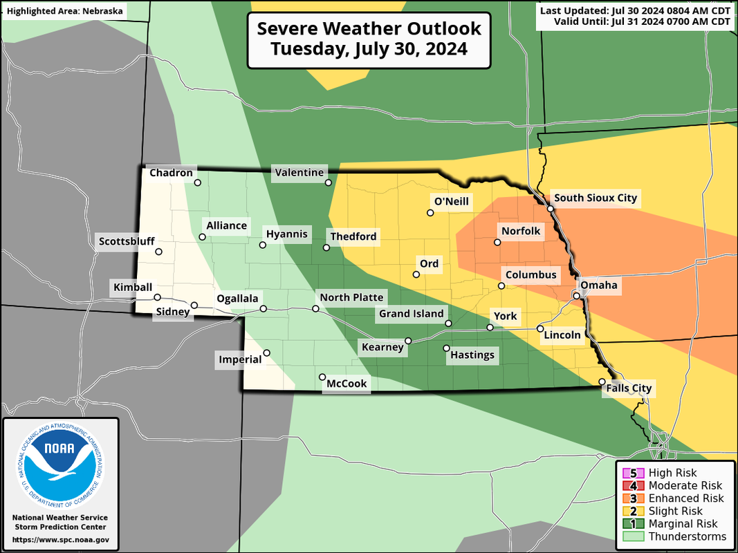
That said, not everyone will get hit and the timing/if it happens locally will depend on capping as these storms will ride along the northern edge of the capping so it'll be key to watch the 700mb temps later today to see if we are really at risk in the local area.
Regardless, please remain weather aware later today/tonight.
Latest outlook:
-
Louie
- County Board
- Posts: 4935
- Joined: Fri Dec 23, 2011 4:23 pm
- Location: Dundee
Re: 2024 Weather Thread
What's the outlook for tomorrow's storms?
-
stormchaser
- Planning Board
- Posts: 2380
- Joined: Fri Jun 01, 2018 8:14 am
Re: 2024 Weather Thread
Tomorrow looks like a better chance of severe weather in the local area in the late afternoon/evening hours as there "shouldn't" be as much of a potential capping issue like there is today in the local area. Still mostly a damaging wind/hail threat though an isolated tornado will be possible.
-
Louie
- County Board
- Posts: 4935
- Joined: Fri Dec 23, 2011 4:23 pm
- Location: Dundee
Re: 2024 Weather Thread
Got it, just seemed like there was a larger chance tomorrow, but your outlook today looked pretty widespread as well.stormchaser wrote: Tue Jul 30, 2024 10:13 amTomorrow looks like a better chance of severe weather in the local area in the late afternoon/evening hours as there "shouldn't" be as much of a potential capping issue like there is today in the local area. Still mostly a damaging wind/hail threat though an isolated tornado will be possible.
-
Busguy2010
- City Council
- Posts: 7325
- Joined: Sat Apr 09, 2011 7:32 pm
- Location: North Central Omaha
Re: 2024 Weather Thread
There was already a large severe, derecho-esque thunderstorm over by Des Moines around 10am. Don't know if that'll sap or shift the available energy for tonight. In any case, I will not be awake for it as it's another over-nighter. Looks like tomorrow evening is actually the better chance of precipitation.