Cermak wrote: Tue Aug 06, 2024 11:16 am
Finally a break in the weather, these next 7-8 days look pretty good with comfortable temps.
Mother nature sure played a cruel joke on us. Hot, hot weather from the end of the storm all the way though today where it looks like there could be hope of getting power restored. Fingers crossed.
But it does feel amazing, comparatively. Come on fall!
Looks like there's currently a marginal risk for Wednesday with potential for an upgrade to slight risk. Strong winds and some hail are risks.
It's way too similar to two weeks ago with timing and day of the week that it's a little triggering. It's been a very stressful past couple weeks and we're far from recovered. Still large piles of limbs everywhere throughout the neighborhood, still hanging branches, still partially downed trees, still houses with damage. Very far from a sense of normalcy, so the last thing we need is anything resembling a version 2.0.
How's everyone else doing as far as cleanup, house damage, etc?
Thankfully, where I live in Bellevue, we don't have many mature trees, and that is what did most of the damage. For the most part, we got almost nothing for damage which is good since many are still getting roofs replaced from the hail storm in June.
The rain last night was nice though....definitely needed that.
Busguy2010 wrote: Mon Aug 12, 2024 4:34 pm
How's everyone else doing as far as cleanup, house damage, etc?
Trees are cleaned up, but more trimming will be required.
I still have tarps still on my roof.
Water remediation work is underway today inside.
Just got the quote on the exterior work this morning.
skinzfan23 wrote: Mon Aug 12, 2024 5:03 pm
The rain last night was nice though....definitely needed that.
It was welcome, but I'm glad it came without wind since I still have tarps on the roof. I got 1.4" at my house.
The threat for severe weather returns to the area with some scattered storms later tonight (mostly overnight/early morning tomorrow) and then a better chance for severe weather tomorrow afternoon/evening including a risk for large hail, damaging wind, and isolated tornadoes.
Tomorrow the risk in Omaha itself will depend on exactly where the storms overnight/early morning end up and consequently where the outflow boundary ends up. The main risk may end up south of town depending on where the boundary is.
stormchaser wrote: Tue Aug 13, 2024 6:46 pm
The threat for severe weather returns to the area with some scattered storms later tonight (mostly overnight/early morning tomorrow) and then a better chance for severe weather tomorrow afternoon/evening including a risk for large hail, damaging wind, and isolated tornadoes.
Tomorrow the risk in Omaha itself will depend on exactly where the storms overnight/early morning end up and consequently where the outflow boundary ends up. The main risk may end up south of town depending on where the boundary is.
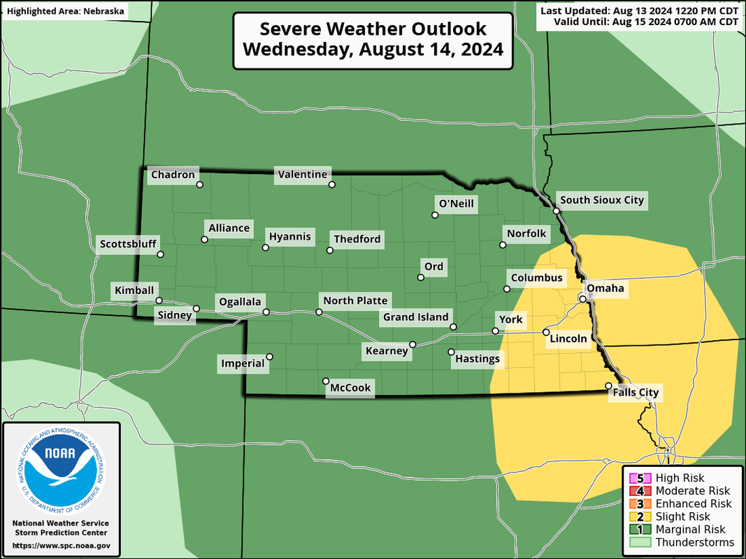
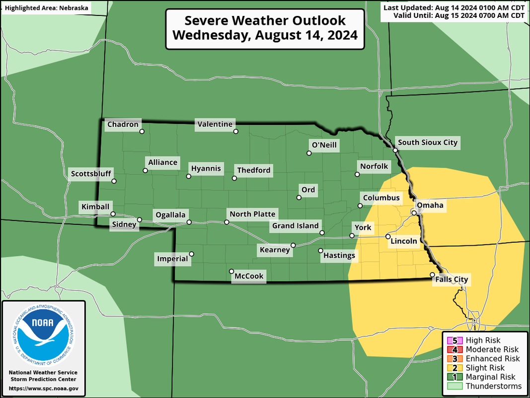
Here is the SPC outlook for tomorrow:
Let’s hope this ends up a rain event. I am SO OVER this severe weather onslaught of 2024.. It’s MORE than made up for the several years we were spared…
Omaha Cowboy wrote: Tue Aug 13, 2024 10:42 pm
I am SO OVER this severe weather onslaught of 2024.. It’s MORE than made up for the several years we were spared…
Totally agree! I've always loved storms and was annoyed at the lack of them for those years, but I'm really over them this now and want a break with a nice long stretch of nothing. I need the summer of 2020 back where it was sunny and in the 90s most days.
Omaha Cowboy wrote: Tue Aug 13, 2024 10:42 pm
I am SO OVER this severe weather onslaught of 2024.. It’s MORE than made up for the several years we were spared…
Totally agree! I've always loved storms and was annoyed at the lack of them for those years, but I'm really over them this now and want a break with a nice long stretch of nothing. I need the summer of 2020 back where it was sunny and in the 90s most days.
I hear you guys, I'd be okay with no severe weather in Omaha itself though I wouldn't mind chasing something south of town tomorrow depending on how things come together.
Some heavy rain potential tonight/early tomorrow somewhere in the area as well...
Certainly looks like a tornado threat tomorrow somewhere near where NE, IA, and MO come together. Depends how much storm coverage there ends up being probably - and like I was saying earlier, what tonight/early tomorrow's storms end up doing and where the subsequent outflow boundary ends up.
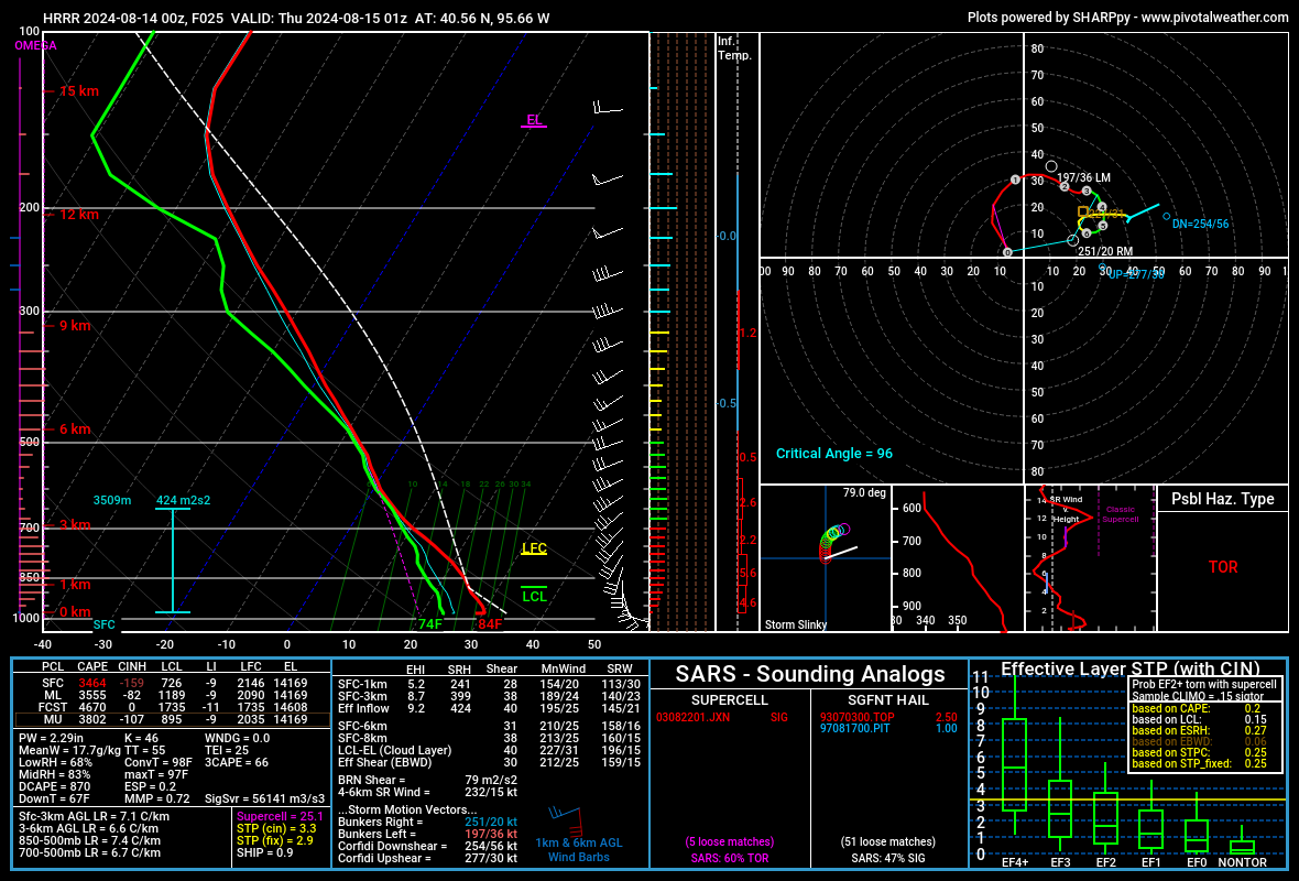
This skew-t sounding is from the 00z HRRR for the aforementioned area south of Omaha. Not perfect but not horrible either:
Omaha Cowboy wrote: Tue Aug 13, 2024 10:42 pm
I am SO OVER this severe weather onslaught of 2024.. It’s MORE than made up for the several years we were spared…
Totally agree! I've always loved storms and was annoyed at the lack of them for those years, but I'm really over them this now and want a break with a nice long stretch of nothing. I need the summer of 2020 back where it was sunny and in the 90s most days.
Don't want the 90s back, I'm loving the 70s and the cool air at night. But I sure agree about the severe weather! I'm probably one of the last people to say I'm sick of storms, but I'm sick of them! This year has been so overactive. I'd take a year or two of snoozer seasons before I'll be yearning to see another severe storm.
Sunday 6/30/2024 - Missouri River crests around 33'
Monday 7/1/2024 - Multiple Inches of Rain
Monday 7/15/2024 - Iowa Derecho
Wednesday 7/31/2024 - 90 MPH Winds
That's a good summary. I've waited on doing any of these events in the events to remember thread because they just keep coming. I think 2024 as a whole will have to be how it goes in there.
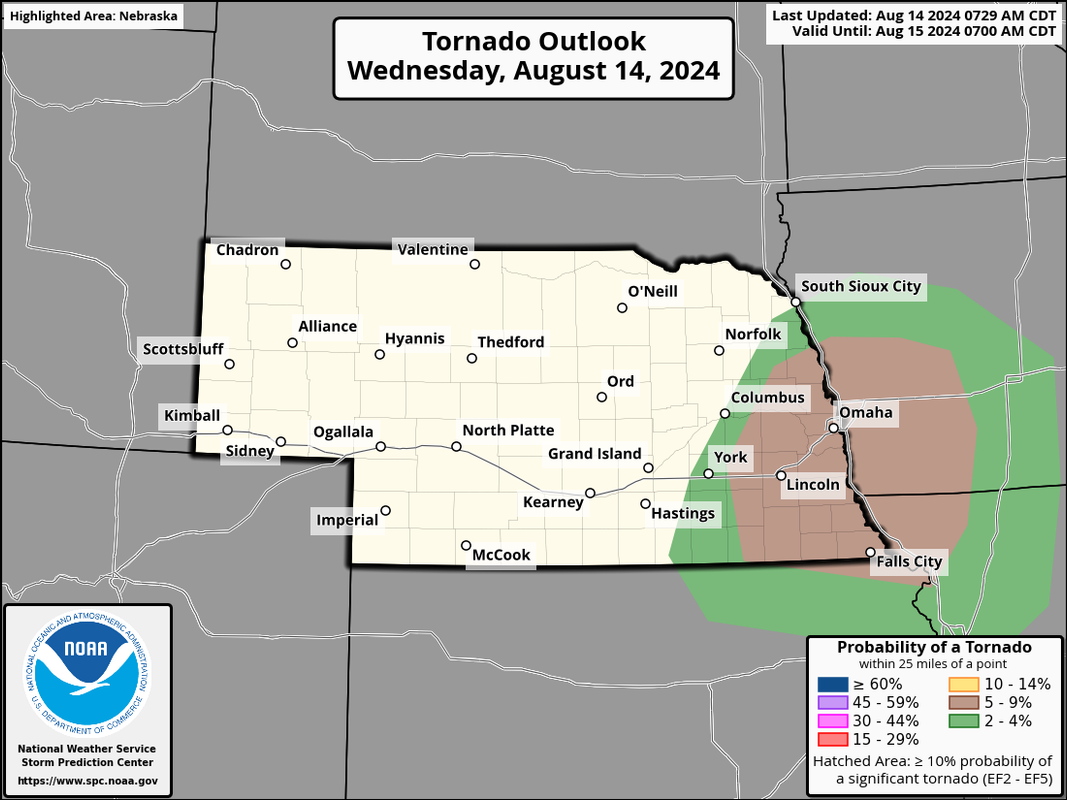
The updated SPC outlook is out now and they have bumped up the tornado risk for our area (including Omaha) to 5% which based on what I've seen on model trends, I'm not surprised.
Brad wrote: Wed Aug 14, 2024 12:33 pm
Nice rain. I got 2.33 in the 90th and Center area. Looks like Sarpy county got absolutely dumped on with radar estimates near 4”.
Just shy of 2" in our gauge overnight in Gretna.
Had 0.8 Sunday night into Monday AM, too.
Not bad for August.
For the record NEBUGEATER does not equal BUGEATER !!!!!!!
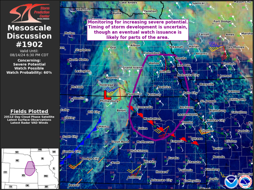
Based on the 12z HRRR anyway, it seems like somewhere between Freemont, Blair, and the northern half of Omaha is most at risk sometime between 6 PM and 9 PM. Obviously it's impossible to know those specifics yet and the mesoanalysis/visibile satellite will need to be watched closely but that area is my preliminary target area for now anyway. Definitely looking like a localized tornado threat especially close to Omaha itself.
Unfortunately it's looking increasingly likely that somewhere in or very close to Omaha is in the "bulls eye" for tornado potential later today/this evening with run to run consistency on the HRRR showing supercellular development in or near town with a relatively strong low level jet (and the storm on the northern edge of that jet). Also, looking at depicted soundings, the low level windshear/helecity is certainly enough for tornadoes.
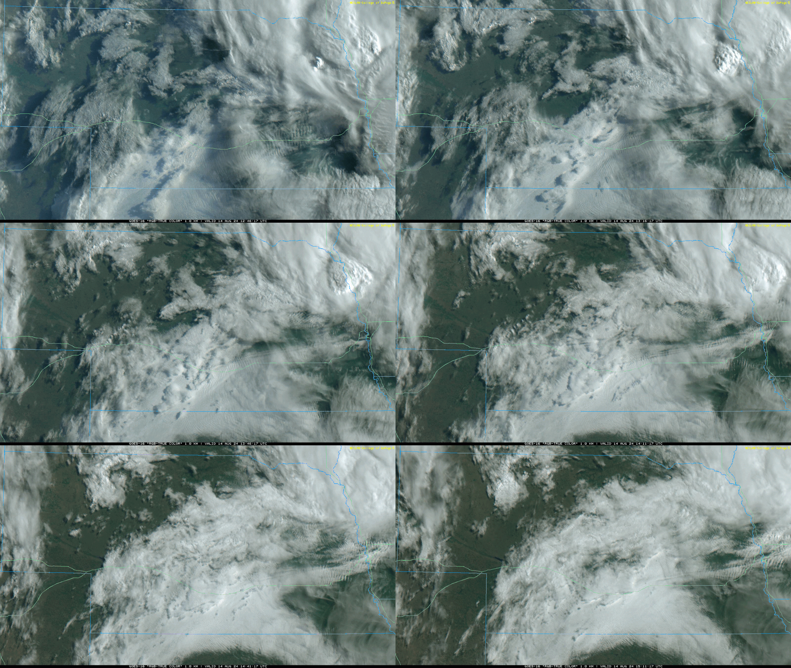
In addition, looking at the visible satellite, a pretty obvious east/west outflow boundary is very close to the Omaha area. Assuming the supercell will embed on this boundary once it develops, it will enhance tornado potential so watching where this nearly stationary boundary ends up later on will be key in determining what area specifically is at a heightened risk for tornadic storms.
To clarify, I'm not trying to freak anyone out or hype things up. I'm just trying to stress the potential and how things currently look to come together but as always they can quickly change. Please remain weather aware - especially if you live anywhere in or near Omaha.
I'm still thinking there is probably 2 main targets to watch for today/this evening. The first is from I-80 on north from near and north of Omaha up towards Fremont/Blair, Missouri Valley, etc. The second is just south of Omaha from between Plattsmouth/Nebraska City over towards Beatirce on south from there towards St Josoph, MO.
The southern target probably has a slightly higher risk for tornadoes and ultimately it will depend on how quickly the storms converge and become more of a MCS, but certainly will be at least be some risk initially as storms are supercellular to start off with today.
stormchaser wrote: Wed Aug 14, 2024 5:55 pm
I'm still thinking there is probably 2 main targets to watch for today/this evening. The first is from I-80 on north from near and north of Omaha up towards Fremont/Blair, Missouri Valley, etc. The second is just south of Omaha from between Plattsmouth/Nebraska City over towards Beatirce on south from there towards St Josoph, MO.
The southern target probably has a slightly higher risk for tornadoes and ultimately it will depend on how quickly the storms converge and become more of a MCS, but certainly will be at least be some risk initially as storms are supercellular to start off with today.
Fingers crossed this misses the Omaha metro completely, and get just get some rain and moderate wind …
Louie wrote: Wed Aug 14, 2024 9:19 pm
Looks like that discussion is trending further south than what you had mentioned. Is that what you're seeing now too?
I think both areas are still at risk though the southern target is the more likely area at risk currently - but I wouldn't be surprised to see a watch issued from Omaha on north/northeast too (penty of uncertainty still either way - especially with timing).
The southern target has more forcing so things in that area could initially be supercellular and then fairly quickly grow more upscale into an HP event. That said, there will probably be some tornadoes in that area.
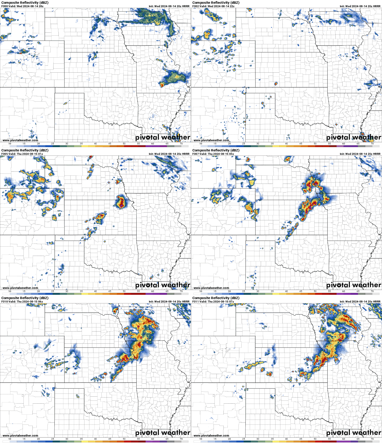
Below is a simulated radar loop from the 20z HRRR showing the 2 areas I'm referring to (though this round hits all of Omaha pretty hard):
I can't tell what model Randby is running, but it's solution is quite different on timing and placement. It is more 18z 3Km NAM solution which probably makes it the GRAF.
Mr.Nuke wrote: Wed Aug 14, 2024 10:13 pm
I can't tell what model Randby is running, but it's solution is quite different on timing and placement. It is more 18z 3Km NAM solution which probably makes it the GRAF.
From what I’ve seen, many tv stations use the RPM model (or they used to)
The risk in Omaha itself might be done - storms fired but died out fairly quick with some light rain in the area stabilizing the atmosphere.
The southern target is verifying though with a tornado warning by Beatrice. That storm will move northeast and should pass south/southeast of Omaha. Around Plattsmouth on south will be at risk.
LLJ is trying to get storms going just to our West. An earlier run of the HRRR hinted that may happen. Still don't think anything severe will come from it.
Mr.Nuke wrote: Thu Aug 15, 2024 1:56 am
LLJ is trying to get storms going just to our West. An earlier run of the HRRR hinted that may happen. Still don't think anything severe will come from it.
I agree, low risk anyway. The main threat will be heavy rainfall.
Brad wrote: Thu Aug 15, 2024 4:18 am
Quite the rain tonight! Got another 1.5" tonight , so 3.8" for the whole day.
Wow, I knew parts of Omaha were just stuck under that rain, I could see all the lightning from Bellevue as well. We did end up getting some rain last night but only .30". (but I got 2.5" yesterday early morning)







 …
…

 …
…