Busguy2010 wrote: Sat Mar 15, 2025 3:13 am
The winds we had a couple weeks ago were even more significant.
Channel 6 was on where I was at when it came through and their superlatives for the wind were pretty over the top. As if we didn't just have stronger winds in a blizzard a couple weeks ago!
I had the same cast on in the background during the storm's arrival, also outside, and I was wondering what they were smokin.
Busguy2010 wrote: Sat Mar 15, 2025 4:04 am
I wasnt but a mile from 84th & Center, and it barely rained and barely any wind. I stood outside as it came in. I wasnt impressed.
Well if it wasn't the wind, a train full of dirt fell off the bridge over the papio creek...
I thought the wind overnight and this morning was more of a nuisance than when the storm rolled in. I know Eppley reported a 62mph gust, but exactly where im at, that simply wasnt the case. Maybe im protected by the hill. Also looking at the storm, it didnt look particularly organized neither by eye or radar. I got bored with it pretty quickly. None of my plants or patio furniture were blown over until I woke up this morning. It was pretty weak, barely met criteria, and the blizzard was more of a problem.
All that said, today looks like just a perfect excuse to really just hang out inside and stay cozy. I love that kind of day, we don't get em as much.
The local news is saying snow, possibly a couple of inches for Wednesday, even if we do get the snow it won’t last long with how warm the temperatures are.
I always find it funny between the contrast of our local weatherman who always freak out about every little storm even if it’s just a 10th of an inch of rain versus eastern Iowa where my wife is from, their weatherman act like it’s 70 and sunny every day and they could be getting 5 inches of snow.
Unfortunately I’d expect winter storm watches to be issued in our area for Wednesday. Looking like another potential blizzard in our area. Unless things change of course.
skinzfan23 wrote: Sun Mar 16, 2025 11:09 pm
I’m no expert but I can’t see this having much of an impact beyond wed morning with how warm the temps are going to be.
Yeah, probably not once it warms up enough anyway.
The track of the storm expected Tuesday night and Wednesday is trending north based on the latest model guidance. If this trend continues, there is a chance Omaha misses out on the majority of the snow (with relatively minor accumulations if this happens). Fingers crossed anyway...
Weather service still saying we are supposed to get snow Wednesday morning 1-3 inches in Omaha more to the north. They could still downgrade it as it’s still a ways out.
Cermak wrote: Mon Mar 17, 2025 4:58 pm
Weather service still saying we are supposed to get snow Wednesday morning 1-3 inches in Omaha more to the north. They could still downgrade it as it’s still a ways out.
Yeah, either way still potentially a blizzard if we get snow. Similar to our last storm, the wind blowing the snow as it’s falling will cause visibility issues even if it doesn’t add up to much (since much will melt as it falls)
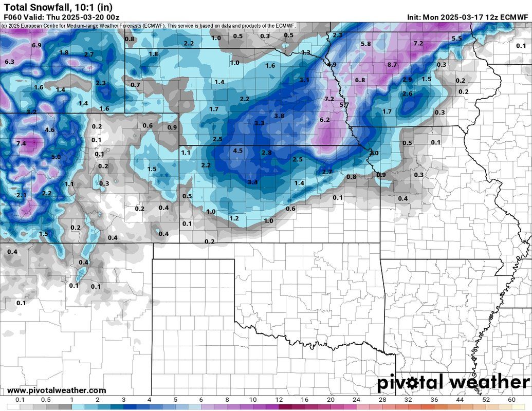
**This isn't a forecast - this is a single run of a single forecast model. Things can and probably will change**
Unfortunately the 12z ECMWF (which is typically more reliable but not always) isn't showing the northward shift like the other models and hits much of our area squarely with a full fledge blizzard.
These depicted snow totals are probably over done but even if you cut them in half, we'll still get ~3 inches of snow locally and with that wind, it'll be a white out as it falls and cause some drifting in open areas like the storm a couple weeks ago.
In addition to snow, a few strong to severe thunderstorms will be possible tomorrow afternoon/evening as the storm moves in. Then potential for thundersnow exists as precip changes to all snow which right now looks to happen sometime between 3 and 6 AM early Wednesday morning (though that will probably change some).
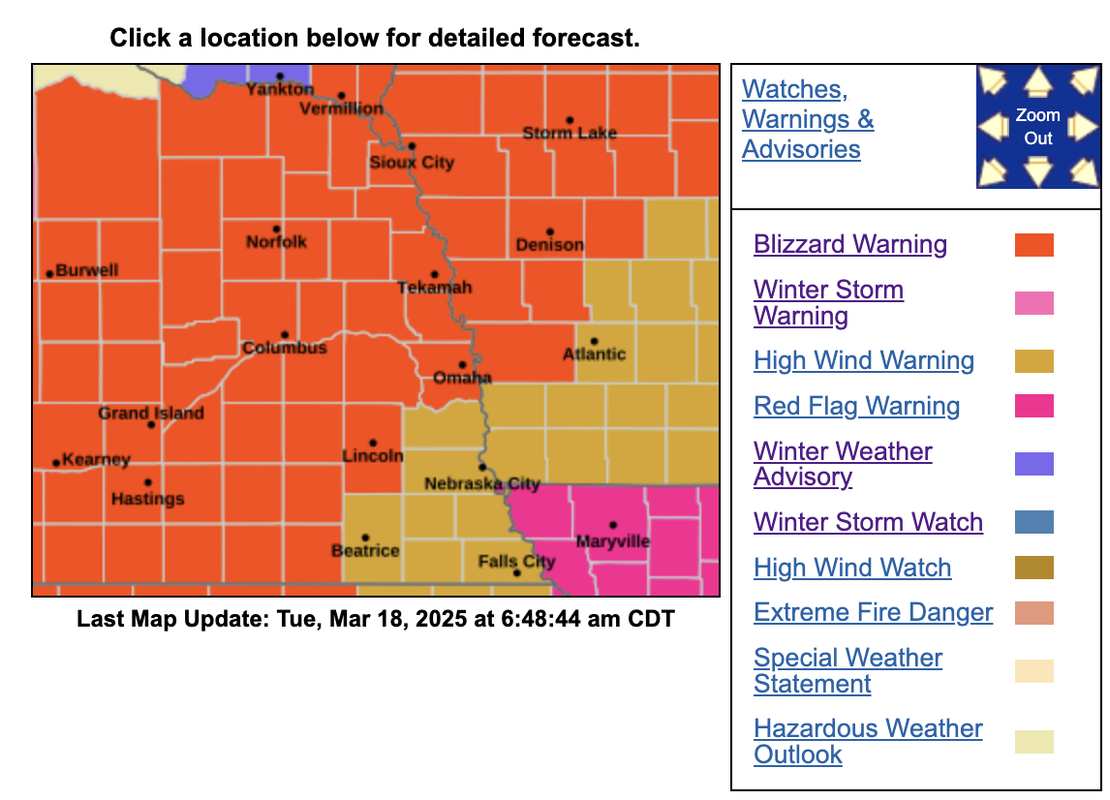
Blizzard warning in effect for Omaha and many of our surrounding areas from 7 AM until 10 PM Wednesday.
Official forecast calls for 2 to 7 inches of snow (with isolated higher amounts) and 65 mph wind gusts though there will be an EXTREMELY sharp cut off in snow totals in or near the Omaha area (southeast portions of the area).
For the time being, I'd say Omaha is more likely to be in the 2 to 4 inches of snow range with heavier snow totals expected to be north and west of town - probably from Fremont to Blair on north/northwest. That said, these types of setups are insanely difficult to forecast and a 1 degree difference in temp can make a HUGE difference in what happens in a given area. So don't be surprised if we end up with totals completely different than what's expected.
Regardless of snow totals, similar to our last storm, this WILL be a blizzard as the snow is falling even if it doesn't stick/accumulate very quickly. Moderate to heavy snow and 65 mph wind gusts will cause whiteouts and make travel impossible for much of the day tomorrow well into the afternoon or until the snow stops and/or changes back over to rain.
Currently, it looks like the rain/thunderstorms overnight tonight will start changing over to snow in Omaha sometime in the 4 AM - 7 AM time frame with the blizzard warning kicking in at 7 AM.
stormchaser wrote: Tue Mar 18, 2025 12:01 pm
Blizzard warning in effect for Omaha and many of our surrounding areas from 7 AM until 10 PM Wednesday.
Official forecast calls for 2 to 7 inches of snow (with isolated higher amounts) and 65 mph wind gusts though there will be an EXTREMELY sharp cut off in snow totals in or near the Omaha area (southeast portions of the area).
For the time being, I'd say Omaha is more likely to be in the 2 to 4 inches of snow range with heavier snow totals expected to be north and west of town - probably from Fremont to Blair on north/northwest. That said, these types of setups are insanely difficult to forecast and a 1 degree difference in temp can make a HUGE difference in what happens in a given area. So don't be surprised if we end up with totals completely different than what's expected.
Regardless of snow totals, similar to our last storm, this WILL be a blizzard as the snow is falling even if it doesn't stick/accumulate very quickly. Moderate to heavy snow and 65 mph wind gusts will cause whiteouts and make travel impossible for much of the day tomorrow well into the afternoon or until the snow stops and/or changes back over to rain.
Currently, it looks like the rain/thunderstorms overnight tonight will start changing over to snow in Omaha sometime in the 4 AM - 7 AM time frame with the blizzard warning kicking in at 7 AM.
Thanks for the update, I know these spring snowstorms storms are among the most difficult to predict. Right now it looks like a repeat of the blizzard from a few weeks ago. Dual March blizzards for Omaha.
Cermak wrote: Tue Mar 18, 2025 12:23 pm
Thanks for the update, I know these spring snowstorms storms are among the most difficult to predict. Right now it looks like a repeat of the blizzard from a few weeks ago. Bookend March blizzards for Omaha.
Yes sir, no problem. Even the timing of the changeover from rain to snow is a crapshoot. I'm thinking sometime in the 4 AM - 7 AM range but it very well could end up happening later than that. Once the changeover occurs though, conditions will likely deteriorate extremely quickly and probably end up catching a large number of people off guard - especially if it happens sometime near the morning commute.
To be honest, I think the weather forecast/predictions are better here than most of the local weather stations. WOWT still is showing 3-6" all the way to NE city, while Ketv and kmtv are showing closer to 1-3" for the Omaha metro which seems to be a little more in line with what you are saying. I still think with the warm temps now and even tomorrow for the most part, it will be hard to stick to concrete surfaces, especially at first. Either way, it won't last long.
skinzfan23 wrote: Tue Mar 18, 2025 1:33 pm
To be honest, I think the weather forecast/predictions are better here than most of the local weather stations. WOWT still is showing 3-6" all the way to NE city, while Ketv and kmtv are showing closer to 1-3" for the Omaha metro which seems to be a little more in line with what you are saying. I still think with the warm temps now and even tomorrow for the most part, it will be hard to stick to concrete surfaces, especially at first. Either way, it won't last long.
Yeah, I'm not surprised to see such a wide range in forecasts. I'm leaning toward the lower end of accumulations here mostly because the temp doesn't really get much below freezing (generally staying in the low 30s throughout). That said, if this thing shifts even slightly southeast, we could get hit pretty good. If it shifts even slightly northwest though, then we might get hardly any accumulation (if anything at all). Somewhere in our are is almost guaranteed to get thundersnow out of this as thunderstorms will be in the area as the precip changes to all snow which is most likely to happen sometime in the 6 AM to 9 AM time frame for our area.
Fingers crossed for this possible Northwest shift …
Looks like the track of this storm has unfortunately shifted south and now Omaha is going to probably get hit pretty hard.
Officially snow totals depicted in the 4"-10" range and wind gusts up to 70 MPH. So this storm is probably going to be stronger than our blizzard a couple weeks ago.
I just watchd Ketv Bill Randby's post and it showed 3-6" for most of the Omaha metro but only 1-3" for things south and east of the metro. Obviously he stated that these storms are hard to pinpoint exactly and models only being off 20 miles can have a huge impact.
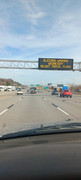
70 degrees, mostly sunny and calm this Tuesday afternoon! Sign over I-80 near 72nd Street a little bit ago.
Gorgeous day today. The grass is just starting to turn a little green. Even Nebraska City has a blizzard warning now, it looks like this is gonna happen.
Thundersnow is imminent I'd say - also, the change over is happening sooner than the NWS was predicting so that may end up leading to higher snow totals in our area (so maybe we'll end up in the 7"-10" of snow range which I realize isn't "way higher" than predicted but still). Officially it's supposed to change to all snow at 10 AM but it's already happening in parts of the metro.
Also, road conditions are pretty bad already including the interstate. It's a sloppy mess from all the sleet.
Just looking at some web cams this morning from a local TV station. The cams from Sarpy county are showing almost no snow on the ground compared to the Omaha ones. Looks like a sharp cutoff. I would imagine it’s pretty bad out in the Elkhorn area and Bennington.
I definitely think I am near the cutoff, it just started snowing lightly here in south Bellevue about 30-45 min ago. You can still clearly see the grass.
This is the hardest I’ve seen it snow all winter. It’s an extremely heavy wet snow. Might not even bother shoveling, should be mostly melted by Friday.
Looking like the temp is just barely too warm that the snow isn't really accumulating very fast so I doubt we will get anywhere close to 7 inches of snow - maybe 4 or 5 inches of snow in some areas but higher totals will probably stay northwest of town where temps have been colder...
stormchaser wrote: Wed Mar 19, 2025 4:41 pm
Looking like the temp is just barely too warm that the snow isn't really accumulating very fast so I doubt we will get anywhere close to 7 inches of snow - maybe 4 or 5 inches of snow in some areas but higher totals will probably stay northwest of town where temps have been colder...
Looks like most is staying northwest of Interstate 680.





 …