skinzfan23 wrote: Sun Mar 30, 2025 11:25 pm
Did we even get any significant rainfall this weekend? I think we got less than .10”. Would have been nice to have some decent totals without the severe weather. Although, I do think with the little bit of moisture along with the warm temps lately, everything has started to really green up.
Hardly anything measurable anyway - the warm front never made it to Omaha staying just barely south of town so all of the storms for the most part stayed south of town too.
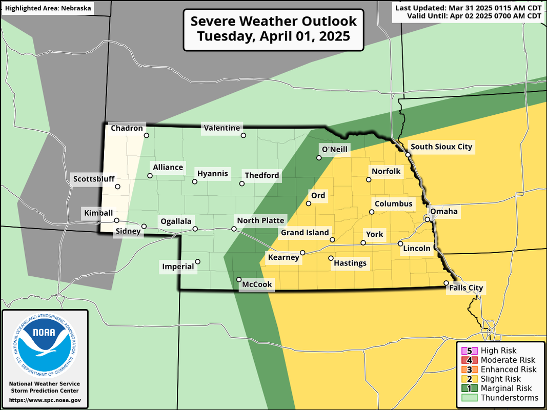
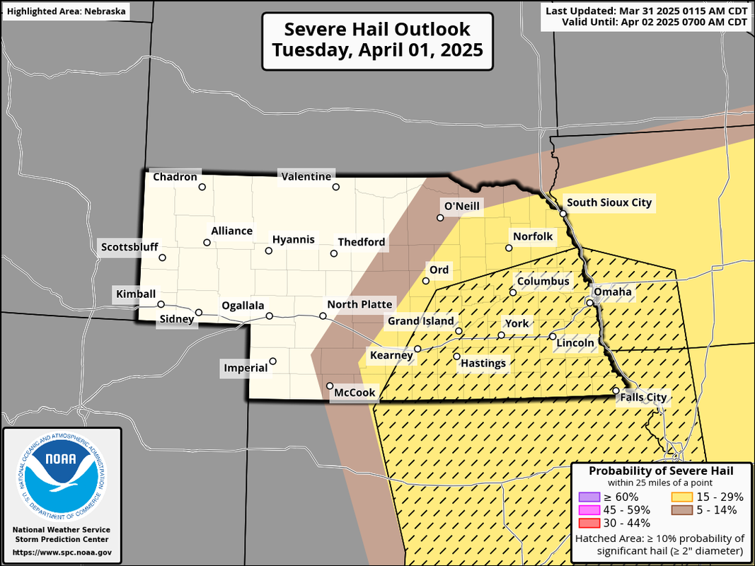
Looks like we'll get more tomorrow night with some potential severe weather. Primarily a large hail threat due to limited moisture though some scattered strong/damaging winds are expected as well.
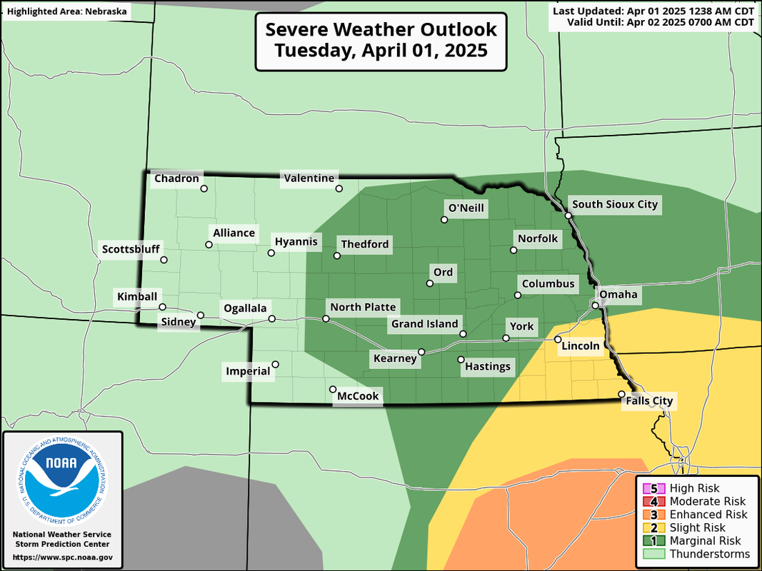
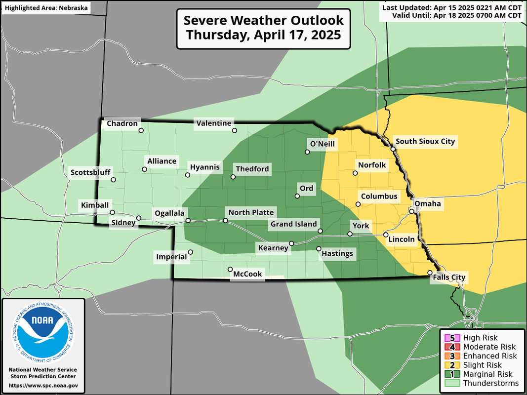
Below is the day 2 outlook from the SPC for tomorrow night that includes a "hatched" area (the area highlighted in black on the 2nd image) where chances are higher for very large hail:
Anybody else relieved by the 14 day forecast? Watched it last night, and it actually looks like it's gonna be closer to normal for this time of year. Saw nothing but 50s and 60s for highs.
The SPC updated and has since removed Omaha from the "slight" risk area and we are now in a marginal risk (with the edge of the slight risk barely to our south). They've decreased the risk in much of NE due to it being unlikely dewpoints will get high enough for widespread severe weather (previously it looked like it "barely" would make it in time).
There will still be a few strong/severe storms but widespread severe weather should remain to our south where dewpoints will be higher - especially into eastern KS.
Louie wrote: Fri Apr 04, 2025 4:39 pm
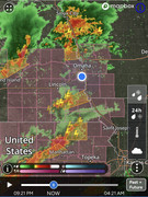
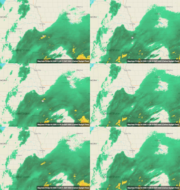
Another funny omadome scenario playing out. Though, I expect there is some inaccuracy causing the perfect roundness of the dome here.
Saw that too - lots of dry air around but its starting to change and fill in so it'll probably be raining here in Omaha soon
Its worth mentioning (if anyone is curious) why the "Omadome" exists.
It comes down to the proximity of Omaha to the radar site more than anything. Since the Earth isn't flat (sorry "flat-earthers"), the further you get from a radar site, the higher up the radar beam is since it shoots out from the radar site in a straight line. Because of this, the radar often shows precip that isn't actually reaching the ground but "appears" to be since it can see it - but that precip is occurring aloft and often is evaporating before reaching the ground.
The closer to the radar site you are, the less of an issue this is where it sees the precip aloft but can't tell that it's evaporating first before falling - consequently it makes it "appear" that there is a dome over the area protecting it since surrounding areas show precip.
I realize most people know there isn't such a thing as a "dome" protecting us and it's just fun to laugh about since it seems to happen frequently but figured I'd mention it for the tinfoil hat people out there anyway.
stormchaser wrote: Fri Apr 04, 2025 6:34 pm
Its worth mentioning (if anyone is curious) why the "Omadome" exists.
It comes down to the proximity of Omaha to the radar site more than anything. Since the Earth isn't flat (sorry "flat-earthers"), the further you get from a radar site, the higher up the radar beam is since it shoots out from the radar site in a straight line. Because of this, the radar often shows precip that isn't actually reaching the ground but "appears" to be since it can see it - but that precip is occurring aloft and often is evaporating before reaching the ground.
The closer to the radar site you are, the less of an issue this is where it sees the precip aloft but can't tell that it's evaporating first before falling - consequently it makes it "appear" that there is a dome over the area protecting it since surrounding areas show precip.
I realize most people know there isn't such a thing as a "dome" protecting us and it's just fun to laugh about since it seems to happen frequently but figured I'd mention it for the tinfoil hat people out there anyway.
It has nothing to do with Omaha's particular urban heat island?
I get what you're saying about the radar not showing precipitation... But it still hasn't rained. You may try to explain away the OmaDome, but it remains misunderstood as to why this ALWAYS happens.
I would assume concrete island first. Biggest city within hundreds of miles in the middle of a bunch of farmland. It's obviously a real thing that probably could be studied. But for now, we joke.
Depends on the situation. There is an urban heat island that likely plays a role but as does soil types (for example soils with a lot of sand will warm faster than other soils and consequently does the same thing by drying the air as a result). The problem is measuring these impacts is currently impossible. One of many unknowns when it comes to weather.
In this case (and often is the case), it was simply dry air that makes it look like lots of precip is falling “everywhere but here” except normally that isn’t the case. Typically the radar is showing precip that’s falling elsewhere but in reality it’s also evaporating. This isn’t exclusive to us though our proximity to western NE and the soil type here plays a role so it might be more frequent here.
It seems like it’s happening a lot because we’ve been in a drought more often than not in recent years. Overcoming the dry air as a result can be difficult during times of drought. Similar to what I stated above, during droughts, the soils also becomes very dry and can “soak up moisture” in the atmosphere at lower levels too.
Like many things with weather, it’s never simple and often several things are contributing to how things unfold. I was just stating why the radar shows what it shows making it LOOK like a “dome” over the area.
Unfortunately it doesn't look like odds are very high for much precip (if anything at all) any time soon either - at least not currently in the next 7-10 days based on the GFS and ECMWF. Hopefully things change.
Interesting for gardeners out there, it looks like a chance we've seen our last freeze on the 8th. Average is around the 16th. Theres not one in the forecast that takes us to the 20th. Now, our last few last freezes have been anomalous, in the low to mid 20th range, so theres still time for another. The NWS says the average last freeze is April 21st, but I believe that's because of the outliers. Since I've kept track, most of the time it's been right around April 16th. I just wanted to point it out in case it doesn't happen, April 8th would by far be the earliest last freeze since I've kept track since 2013. An AI search says the earliest last freeze ever was April 12th (not sure I trust the AI stuff). According to that, this would then be a record, if it does indeed happen. Something to watch for. I've confidently set my plants out and I'm not worried about them for the foreseeable future.
Good observation. I was thinking the same thing. Comparing to pictures of previous years, everything is growing and more green than it has been at this time in recent memory. However, we still badly need some rain.
Models are trending towards potentially a more active weather pattern now in our area so if this trend verifies as shown, we could have several upcoming severe weather setups starting as early as this coming Thursday, April 17th (though odds are higher to our northeast into parts of IA with that specific setup currently). Even some setups with tornado potential upcoming - again, if trends verify.
Obviously it can always change again but considering we are moving into the part of April where we had tornadoes in the local area last year, this trend is concerning and something I feel is at least worth mentioning and giving a early heads up.
I am now very confident we've seen our last freeze. Just watched Bill's 14 day forecast which takes us to 4/27. Nothing even close to 32, not even 30's at all. If we get past 4/27 and see a freeze after that, it would be extremely anomalous. Equally anomalous to see a last freeze as early as 4/8.
Our climate has just become exhaustively warm and dry.
Still a severe weather risk for this coming Thursday that includes the Omaha area. These storms will likely be scattered supercells so odds are going to be higher you won't get hit by one of these. That being said, there will be a threat for large hail to very large hail with them (which is the primary threat) and at least some tornado and damaging wind threat. The tornado threat would be higher but the low level winds look pretty "meh" currently though that can change of course as short range models (which are higher resolution) start picking up on the threat.
In addition to a threat for severe weather Thursday, there is another threat this coming Sunday (though the SPC doesn't yet have a risk area for Sunday - at least nothing anywhere close to here). Currently the threat Sunday is higher southeast of Omaha into MO but it's too far out to know. Otherwise Sunday might be a pretty good soaker in parts of the area which is obviously much needed.
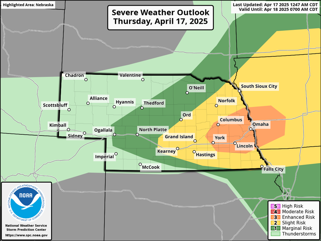
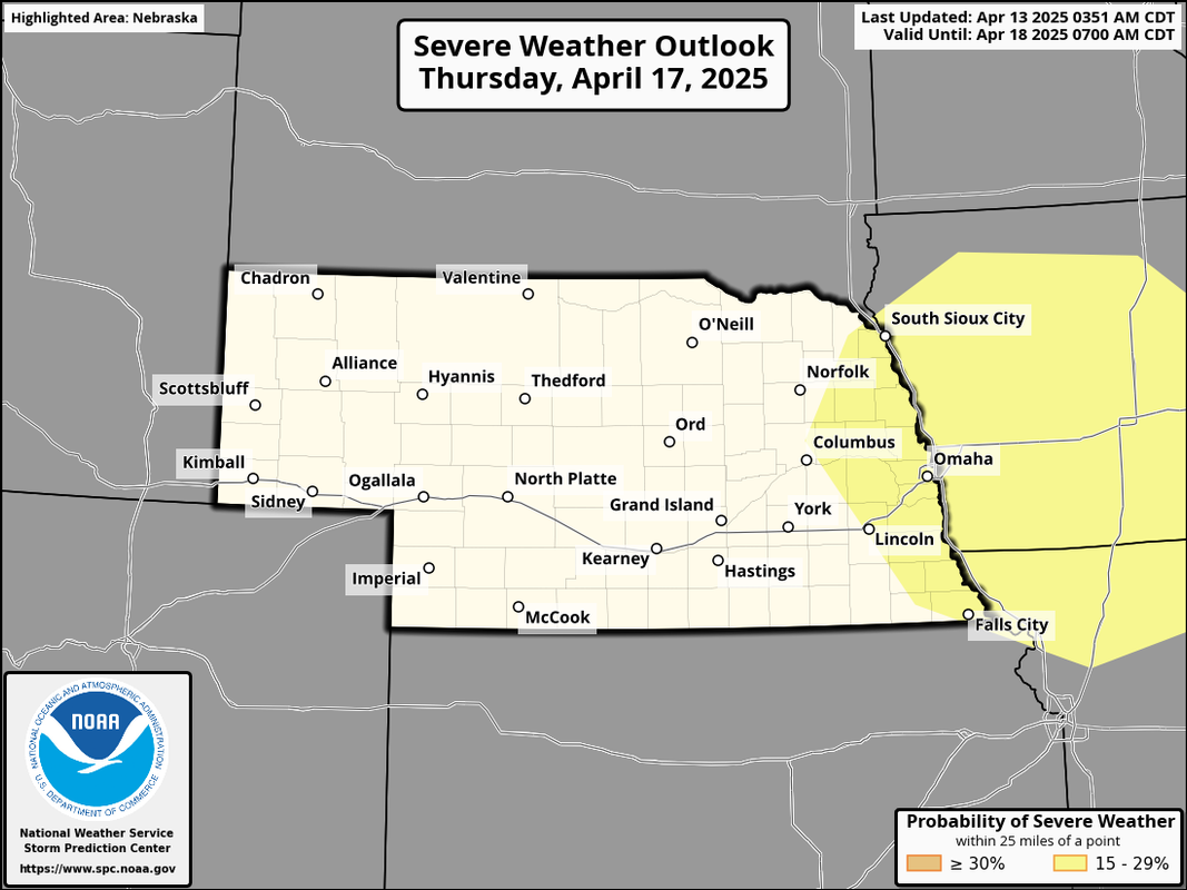
Anyhow, here is the current risk area for Thursday:
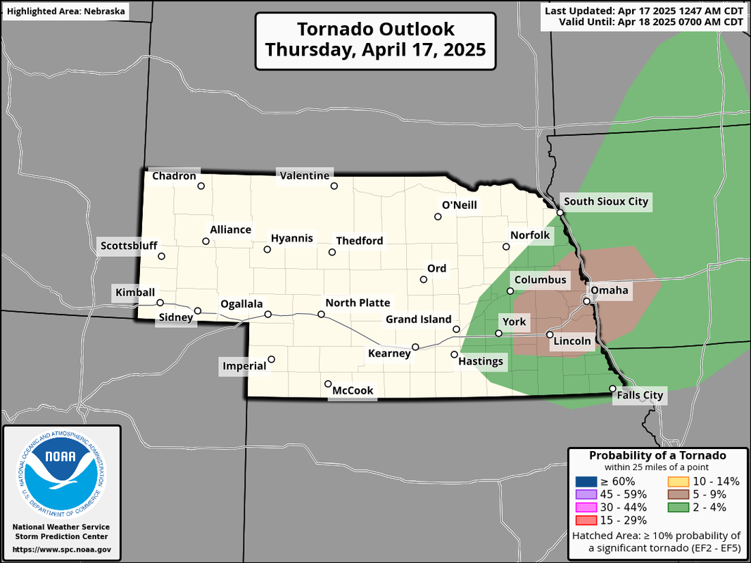
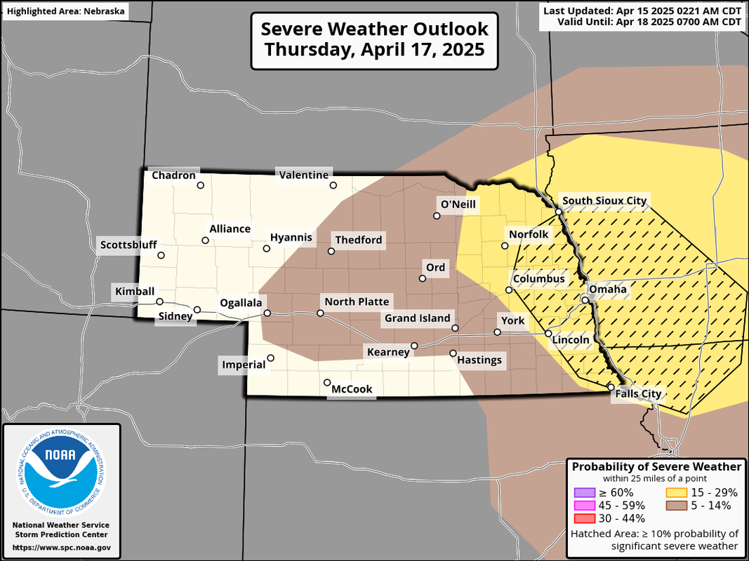
Below is the probability map which shows a "hatched" area (the black outlined area on the map) which is where there is a higher risk for supercells/very large hail.
I just saw Reed Timmer will be in the Omaha area chasing with the Dominator on Thursday. He stated Omaha was in the “bullseye”..
I get the sense as we near Thursday, that “2” slight risk might move to “3” enhanced..That’s of course, my amateur tea leaf arm-chair weather guess for the week …
Omaha Cowboy wrote: Tue Apr 15, 2025 11:19 pm
I just saw Reed Timmer will be in the Omaha area chasing with the Dominator on Thursday. He stated Omaha was in the “bullseye”..
I get the sense as we near Thursday, that “2” slight risk might move to “3” enhanced..That’s of course, my amateur tea leaf arm-chair weather guess for the week …
Ciao..LiO…Peace
We are definitely in the "bullseye" for supercell potential with primarily a large hail threat. Some of these will probably produce baseball size hail - possibly larger. The surface winds aren't veered enough for a higher tornado threat though an isolated tornado or 2 will be possible (IMO anyway). They're too southerly/southwesterly as opposed to more southeasterly/easterly so the low level wind shear isn't ideal for tornadoes.
That being said, even though we may be in the bullseye, it doesn't guarantee Omaha specifically will be hit. In fact, chances are way higher we won't since these storms will be scattered supercells. Obviously stay weather aware if you live in Omaha (or surrounding areas), but I'm just stressing this fact so people are clear on what to expect. Anyone who DOES get hit by one of these (whether in Omaha or elsewhere), they're unfortunately probably going to have some pretty widespread hail damage. Fingers crossed that doesn't happen in Omaha.
What's the rain situation look like? Would tonight be a good time to put down Lanoha's first round of lawn treatment ahead of the early and late rounds of weather tomorrow? Needs 1/2" of water within 24hrs.
almighty_tuna wrote: Wed Apr 16, 2025 1:26 pm
What's the rain situation look like? Would tonight be a good time to put down Lanoha's first round of lawn treatment ahead of the early and late rounds of weather tomorrow? Needs 1/2" of water within 24hrs.
If its granular fertilizer, that 24 hours is kind of BS. You could put it down and if we don't get a half inch, you could go water it on Monday and be just fine.
They say 24 hours so they are "correct" when it says "Greener Grass in just 10 Days" or whatever claim they make. Granular fertilizer doesn't start working until it gets watered, but it doesn't go bad just sitting on the lawn for a few extra days.
almighty_tuna wrote: Wed Apr 16, 2025 1:26 pm
What's the rain situation look like? Would tonight be a good time to put down Lanoha's first round of lawn treatment ahead of the early and late rounds of weather tomorrow? Needs 1/2" of water within 24hrs.
Personally I'd wait - Sunday is looking more ideal for that currently.
Since the storms tomorrow will be scattered (or might be anyway), it's probably too risky to really know how much rain we will get at your specific location. Chances are, most places won't get that much though a few might.
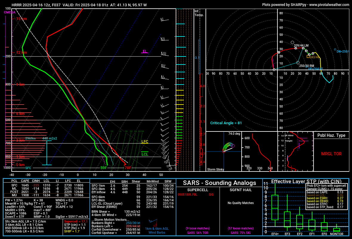
Based on the 12z HRRR, the "highest" tornado potential is extremely close to Omaha for tomorrow. Where ever the southern most storm ends up will likely have the best chance and based on the 12z run, our area will have that storm as well as marginally sufficient low level winds. I put "highest" in quotes because the risk is very marginal IMO.
Bases will probably end up on the elevated side and considering a cold front will be pushing in from the west which will undercut the storms (causing them to be more outflow dominant), the inflow feeding into any mesosyclone/storm from the east/southeast will have a difficult time sustaining itself - and consequently cut way down on any tornado risk. Isolated tornadoes will be possible still though.
Below is a sounding from just barely south of Omaha based on the 12z HRRR. With nearly a 20 degree temp/dewpoint discrepancy, it reinforces the belief these storms will likely be on the elevated side. The lower levels do have some decent veering of the winds with backed surface winds so if the storms didn't end up being elevated, they'd be able to tap into that more and have an increased tornado risk - but as such, these will mostly be elevated, monster hail producing supercells.
The most likely time frame for Omaha currently is between 5 PM and 8 PM tomorrow.
stormchaser wrote: Wed Apr 16, 2025 1:40 pm
Personally I'd wait - Sunday is looking more ideal for that currently.
Brad wrote: Wed Apr 16, 2025 1:39 pm
They say 24 hours so they are "correct" when it says "Greener Grass in just 10 Days" or whatever claim they make. Granular fertilizer doesn't start working until it gets watered, but it doesn't go bad just sitting on the lawn for a few extra days.
stormchaser wrote: Wed Apr 16, 2025 1:40 pm
Personally I'd wait - Sunday is looking more ideal for that currently.
Brad wrote: Wed Apr 16, 2025 1:39 pm
They say 24 hours so they are "correct" when it says "Greener Grass in just 10 Days" or whatever claim they make. Granular fertilizer doesn't start working until it gets watered, but it doesn't go bad just sitting on the lawn for a few extra days.
Omaha Cowboy wrote: Tue Apr 15, 2025 11:19 pm
I just saw Reed Timmer will be in the Omaha area chasing with the Dominator on Thursday. He stated Omaha was in the “bullseye”..
I get the sense as we near Thursday, that “2” slight risk might move to “3” enhanced..That’s of course, my amateur tea leaf arm-chair weather guess for the week …
Ciao..LiO…Peace
We are definitely in the "bullseye" for supercell potential with primarily a large hail threat. Some of these will probably produce baseball size hail - possibly larger. The surface winds aren't veered enough for a higher tornado threat though an isolated tornado or 2 will be possible (IMO anyway). They're too southerly/southwesterly as opposed to more southeasterly/easterly so the low level wind shear isn't ideal for tornadoes.
That being said, even though we may be in the bullseye, it doesn't guarantee Omaha specifically will be hit. In fact, chances are way higher we won't since these storms will be scattered supercells. Obviously stay weather aware if you live in Omaha (or surrounding areas), but I'm just stressing this fact so people are clear on what to expect. Anyone who DOES get hit by one of these (whether in Omaha or elsewhere), they're unfortunately probably going to have some pretty widespread hail damage. Fingers crossed that doesn't happen in Omaha.
As always, thanks for the insight. I appreciate you!…
Unfortunately the tornado threat has increased some since I posted yesterday with low winds becoming more favorable over our area specifically. As a result, the SPC has upgraded us to an enhanced risk and includes a 5% tornado risk.
The main risk in Omaha itself still looks to be between 5 PM and 8 PM.
Based on model guidance, I'll probably target somewhere between Blair and Missouri Valley/Logan and areas east from there with potentially a tornadic storm moving through that specific area sometime around 7 PM (roughly)...
Personally I think odds are fairly hight that Omaha itself won't see much for storms today. Everything will likely stay north of town with initiation starting northwest of Omaha during the mid to late afternoon hours and then things organizing into supercells north of Omaha (towards Blair) and potentially becoming tornadic shortly there after as it approaches and crosses the Missouri River.
That being said, if you live in or near Omaha, remain weather aware regardless.
All outlets saying the same. Theres going to be maybe ONE bad storm. If you get it, you might get it bad. It may be a bad mofo with 3" hail and a potentially strong tornado. I'd love to go see it, cause I get the feeling it's gonna be a big green monster.
WOWT and KETV both illustrated what loosely looked like a classic super cell up north of the metro. I personally am not real confident we in Omaha are gonna see much of anything. But, anything can change. I've watered all my stuff today cause I'm just not confident it's gonna rain little, if at all, if that says anything.
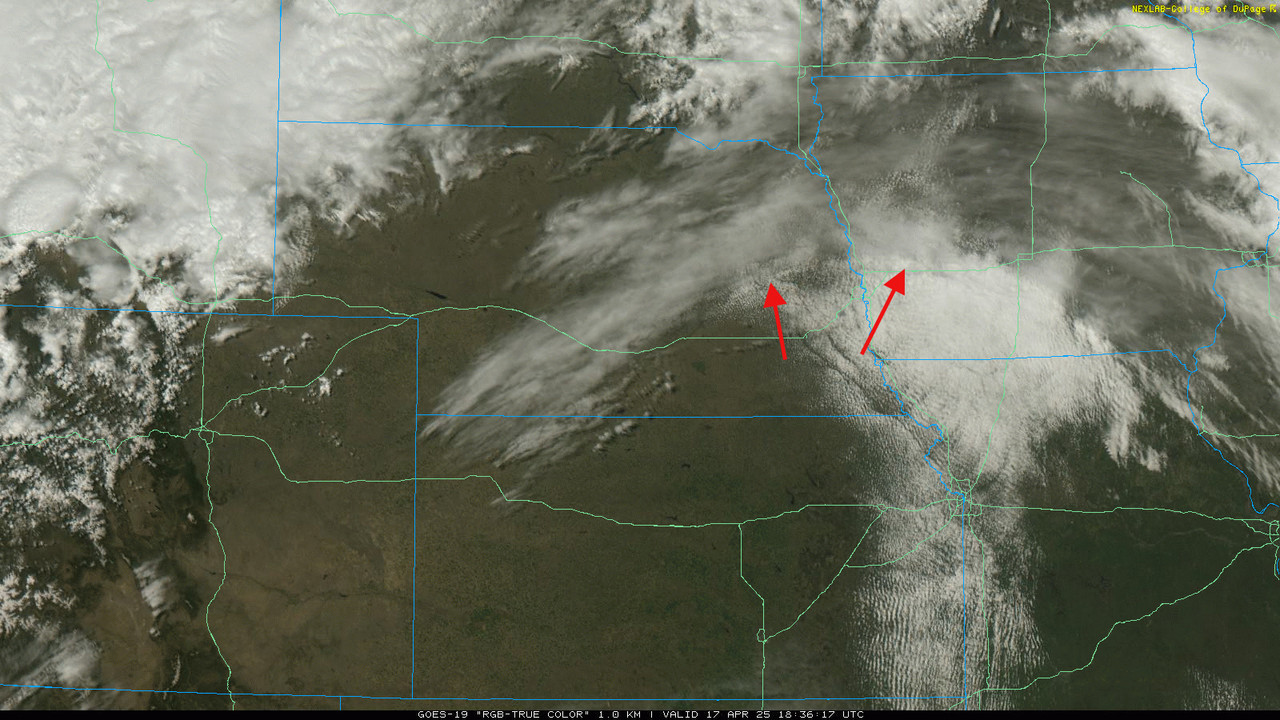
This boundary that I have the red arrows pointing to is part of the reason why I think the main supercell/tornado potential will end up north of Omaha. If a storm embed on this boundary (which it probably will), it will add helicity and cause the storm to rotate even more. This will increase the chances for a supercell/tornado - especially as the low level jet starts to kick in around 7 PM.
South of this boundary, there is currently a fair amount of convective inhibition (cinh) - which you can see in the "waves" on the clouds looking at the satellite. Eventually this convective inhibition/capping may decrease. IF that happens, Omaha could be at risk yet so we will see what happens.





 …