2025 Weather Thread
-
stormchaser
- Planning Board
- Posts: 2380
- Joined: Fri Jun 01, 2018 1:14 pm
Re: 2025 Weather Thread
Based on recent model trends, a slight southward shift has been observed. I still think the main risk is just barely north of Omaha but its close enough that don't be surprised if Omaha/Council Bluffs ends up in a tornado warning in a few hours.
-
Brad

- Photographer
- Posts: 1036702
- Joined: Sun Feb 29, 2004 12:03 am
- Location: Omaha, NE
Re: 2025 Weather Thread
SPC Just put out an MDstormchaser wrote: Thu Apr 17, 2025 7:52 pm Based on recent model trends, a slight southward shift has been observed. I still think the main risk is just barely north of Omaha but its close enough that don't be surprised if Omaha/Council Bluffs ends up in a tornado warning in a few hours.
You do not have the required permissions to view the files attached to this post.

Omaha Skyline Photos, Omaha Aerial Photos, and More.
Website: www.bradwilliamsphotography.com
Facebook: www.facebook.com/bradwilliamsphotography
Twitter: www.twitter.com/bradwphoto
Instagram: www.instagram.com/bradwilliamsphotography
YouTube: www.youtube.com/@bradwilliamsphoto
-
Mr.Nuke
- Parks & Recreation
- Posts: 1230
- Joined: Wed May 09, 2007 3:12 am
- Location: Omaha
Re: 2025 Weather Thread
I'd lean that way too, but if the HRRR isn't correct and the Hi-Res NAM is, Douglas County is inline for severe weather and potentially the second part of the your second sentence.stormchaser wrote: Thu Apr 17, 2025 7:52 pm Based on recent model trends, a slight southward shift has been observed. I still think the main risk is just barely north of Omaha but its close enough that don't be surprised if Omaha/Council Bluffs ends up in a tornado warning in a few hours.
-
Mr.Nuke
- Parks & Recreation
- Posts: 1230
- Joined: Wed May 09, 2007 3:12 am
- Location: Omaha
-
iamjacobm

- City Council
- Posts: 10829
- Joined: Sat Apr 10, 2010 11:52 am
- Location: Chicago
-
iamjacobm
- City Council
- Posts: 10829
- Joined: Sat Apr 10, 2010 11:52 am
- Location: Chicago
-
nativeomahan

- County Board
- Posts: 6029
- Joined: Fri Nov 12, 2004 8:46 pm
- Location: Omaha and Puerto Vallarta
Re: 2025 Weather Thread
OmaDome
-
Cermak
- Planning Board
- Posts: 2348
- Joined: Thu Nov 29, 2018 7:02 pm
Re: 2025 Weather Thread
Some damage reported in Fremont and northern Douglas county. Not on the scale of Elkhorn, but still moderate damage. On a positive note most of Omaha received some much needed rain.
-
stormchaser
- Planning Board
- Posts: 2380
- Joined: Fri Jun 01, 2018 1:14 pm
Re: 2025 Weather Thread
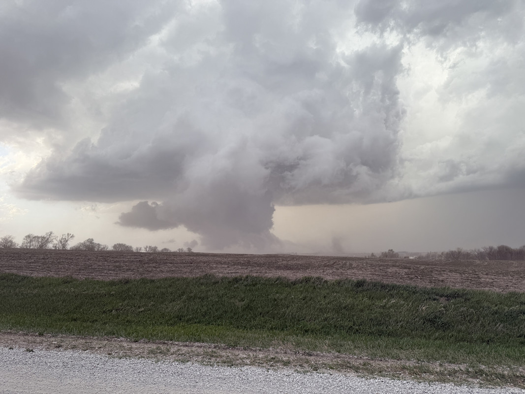
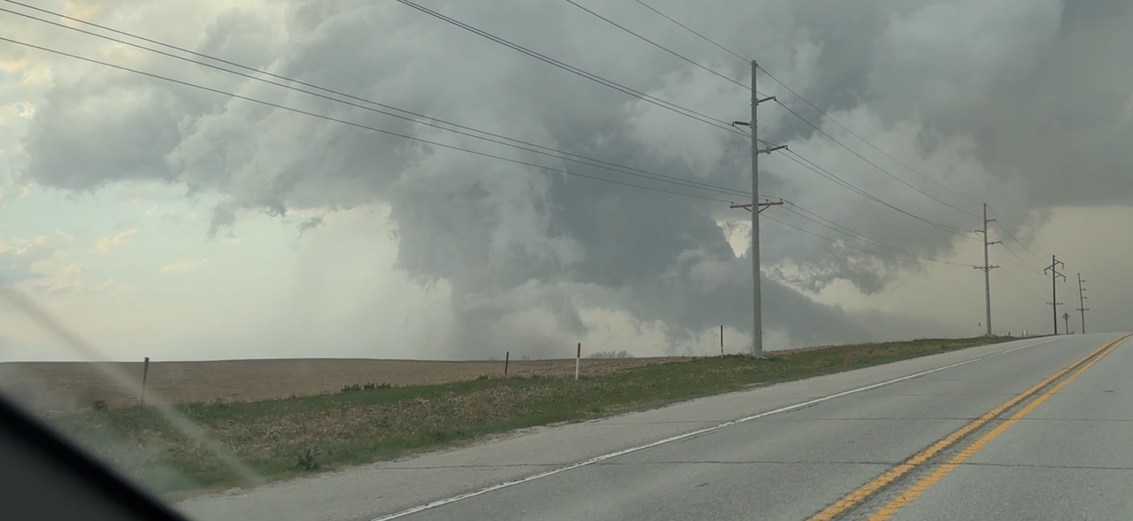
Ended up seeing what I believe to be at least 2 dusty/ragged looking tornadoes on the storm that passed south of Omaha. Hard to tell for sure how much things were in the ground at times due to all the dust being kicked up from the RFD/rotation being undercut, but definite rotation aloft and debris kicked up beneath…
-
Brad
- Photographer
- Posts: 1036702
- Joined: Sun Feb 29, 2004 12:03 am
- Location: Omaha, NE
Re: 2025 Weather Thread
Nice! Good local chase to get out on.stormchaser wrote: Fri Apr 18, 2025 1:36 am Ended up seeing what I believe to be at least 2 dusty/ragged looking tornadoes on the storm that passed south of Omaha. Hard to tell for sure how much things were in the ground at times due to all the dust being kicked up from the RFD/rotation being undercut, but definite rotation aloft and debris kicked up beneath…
I see Reed is still chasing down by Red Oak right now. They just intercepted by Essex IA.
Omaha Skyline Photos, Omaha Aerial Photos, and More.
Website: www.bradwilliamsphotography.com
Facebook: www.facebook.com/bradwilliamsphotography
Twitter: www.twitter.com/bradwphoto
Instagram: www.instagram.com/bradwilliamsphotography
YouTube: www.youtube.com/@bradwilliamsphoto
-
iamjacobm
- City Council
- Posts: 10829
- Joined: Sat Apr 10, 2010 11:52 am
- Location: Chicago
Re: 2025 Weather Thread
Looks like some monster tornados fired up in Iowa.
-
Brad
- Photographer
- Posts: 1036702
- Joined: Sun Feb 29, 2004 12:03 am
- Location: Omaha, NE
Re: 2025 Weather Thread
Seems like we got straight from winter to storm season. What happened to the spring rains we use to get?
Omaha Skyline Photos, Omaha Aerial Photos, and More.
Website: www.bradwilliamsphotography.com
Facebook: www.facebook.com/bradwilliamsphotography
Twitter: www.twitter.com/bradwphoto
Instagram: www.instagram.com/bradwilliamsphotography
YouTube: www.youtube.com/@bradwilliamsphoto
-
GenX
- Parks & Recreation
- Posts: 1252
- Joined: Fri Feb 05, 2016 2:16 am
- Location: Omaha
Re: 2025 Weather Thread
At this point I’m putting climate change deniers right up there with flat-earthers…Brad wrote: Fri Apr 18, 2025 1:05 pm Seems like we got straight from winter to storm season. What happened to the spring rains we use to get?
-
stormchaser
- Planning Board
- Posts: 2380
- Joined: Fri Jun 01, 2018 1:14 pm
Re: 2025 Weather Thread
Sunday we will get a nice soaking rain for a change - unless things change but that's how it looks currently.Brad wrote: Fri Apr 18, 2025 1:05 pm Seems like we got straight from winter to storm season. What happened to the spring rains we use to get?
-
Busguy2010

- City Council
- Posts: 7397
- Joined: Sun Apr 10, 2011 12:32 am
- Location: North Central Omaha
Re: 2025 Weather Thread
There's still time. The 1913 Easter tornado happened on March 23rd, so it by far isn't the earliest tornado.
I'm more concerned that we've consistently been in a recurring drought year after year, and the regular occurance of record challenging warm days we've had lately.
I observe a creek on a daily basis, and I basically forgot it was there. Yesterday was the first time in (???) that I actually noticed a decent amount of water flowing through it. And when I say "decent" that probably just qualifies as normally low. It's been low and stopped up probably since last May.
-
stormchaser
- Planning Board
- Posts: 2380
- Joined: Fri Jun 01, 2018 1:14 pm
Re: 2025 Weather Thread
Yeah, I've seen them in early March some years - been a dry start but it can quickly change and Sunday's rainfall should help. Some places could end up getting in excess of an inch of rain out of it.Busguy2010 wrote: Fri Apr 18, 2025 2:58 pmThere's still time. The 1913 Easter tornado happened on March 23rd, so it by far isn't the earliest tornado.
I'm more concerned that we've consistently been in a recurring drought year after year, and the regular occurance of record challenging warm days we've had lately.
I observe a creek on a daily basis, and I basically forgot it was there. Yesterday was the first time in (???) that I actually noticed a decent amount of water flowing through it. And when I say "decent" that probably just qualifies as normally low. It's been low and stopped up probably since last May.
-
stormchaser
- Planning Board
- Posts: 2380
- Joined: Fri Jun 01, 2018 1:14 pm
Re: 2025 Weather Thread
Footage of one of the brief tornadoes I saw near Weeping Water. This storm was very ragged/scuddy but it definitely wrapped up at times on the left side of the wall cloud and you can see a funnel (or 2) try to fully condense as debris is being kicked up.
-
Cermak
- Planning Board
- Posts: 2348
- Joined: Thu Nov 29, 2018 7:02 pm
Re: 2025 Weather Thread
Would that be like an EF1 or EF0 ?stormchaser wrote: Fri Apr 18, 2025 3:38 pm Footage of one of the brief tornadoes I saw near Weeping Water. This storm was very ragged/scuddy but it definitely wrapped up at times on the left side of the wall cloud and you can see a funnel (or 2) try to fully condense as debris is being kicked up.
-
stormchaser
- Planning Board
- Posts: 2380
- Joined: Fri Jun 01, 2018 1:14 pm
Re: 2025 Weather Thread
Unless it hit something (which is unlikely), it would be an EF-0 or "unknown".
-
Louie
- County Board
- Posts: 4968
- Joined: Fri Dec 23, 2011 10:23 pm
- Location: Dundee
Re: 2025 Weather Thread
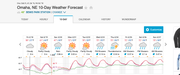
God, I hope this forecast is accurate. We need the precip.
-
Busguy2010
- City Council
- Posts: 7397
- Joined: Sun Apr 10, 2011 12:32 am
- Location: North Central Omaha
Re: 2025 Weather Thread
I vote EF-Ustormchaser wrote: Fri Apr 18, 2025 3:59 pmUnless it hit something (which is unlikely), it would be an EF-0 or "unknown".
-
Brad
- Photographer
- Posts: 1036702
- Joined: Sun Feb 29, 2004 12:03 am
- Location: Omaha, NE
Re: 2025 Weather Thread
Its amazing how many people still look at tornado video or photos and say "That looks like an EF_". The EF rating is a study of the damage on the ground after a tornado and not the tornado itself.stormchaser wrote: Fri Apr 18, 2025 3:59 pmUnless it hit something (which is unlikely), it would be an EF-0 or "unknown".
National Weather Service wrote:The EF Scale incorporates 28 damage indicators (DIs) such as building type, structures, and trees. For each damage indicator, there are 8 degrees of damage (DOD) ranging from the beginning of visible damage to complete destruction of the damage indicator.
Omaha Skyline Photos, Omaha Aerial Photos, and More.
Website: www.bradwilliamsphotography.com
Facebook: www.facebook.com/bradwilliamsphotography
Twitter: www.twitter.com/bradwphoto
Instagram: www.instagram.com/bradwilliamsphotography
YouTube: www.youtube.com/@bradwilliamsphoto
-
stormchaser
- Planning Board
- Posts: 2380
- Joined: Fri Jun 01, 2018 1:14 pm
Re: 2025 Weather Thread
Yep, it is - though the system is flawed. It's silly that a tornado MUST do damage for them to determine strength. For example, if they have radar data from a nearby DOW truck or a nearby NWS office like the Greenfield, IA tornado last year that had measured wind speeds in excess of 300 mph and yet was rated EF-3. Or the amount of tornadoes that simply don't hit anything while at peak intensity and consequently the rating isn't really reflective of the actual strength of the tornado. I realize if they don't have close proximity radar, then there isn't much they can do - but still, the amount of tornadoes that probably SHOULD be rated an EF-4 or EF-5 is pretty crazy when you think about it.Brad wrote: Fri Apr 18, 2025 5:41 pmIts amazing how many people still look at tornado video or photos and say "That looks like an EF_". The EF rating is a study of the damage on the ground after a tornado and not the tornado itself.stormchaser wrote: Fri Apr 18, 2025 3:59 pmUnless it hit something (which is unlikely), it would be an EF-0 or "unknown".
National Weather Service wrote:The EF Scale incorporates 28 damage indicators (DIs) such as building type, structures, and trees. For each damage indicator, there are 8 degrees of damage (DOD) ranging from the beginning of visible damage to complete destruction of the damage indicator.
-
Busguy2010
- City Council
- Posts: 7397
- Joined: Sun Apr 10, 2011 12:32 am
- Location: North Central Omaha
Re: 2025 Weather Thread
I mean technically, yeah, the EF rating is based on the damage done, or estimated wind speeds... But come on, look at that thing, it's weak af. Sorry to judge that poor tornado 
Same goes for larger, more intense tornadoes that don't hit anything. You look, see a monster, and you know to leave.
See a little weak thing, maybe stick around. It's simple.
Same goes for larger, more intense tornadoes that don't hit anything. You look, see a monster, and you know to leave.
See a little weak thing, maybe stick around. It's simple.
Last edited by Busguy2010 on Fri Apr 18, 2025 7:38 pm, edited 1 time in total.
-
Busguy2010
- City Council
- Posts: 7397
- Joined: Sun Apr 10, 2011 12:32 am
- Location: North Central Omaha
Re: 2025 Weather Thread
I'm saying you can tell how intense a tornado is just by looking at it and being around it. It doesn't have to do any damage for you to be able to tell "what that thing would have been rated if it had gone over a city".
-
stormchaser
- Planning Board
- Posts: 2380
- Joined: Fri Jun 01, 2018 1:14 pm
Re: 2025 Weather Thread
I never said the tornadoes I saw yesterday were strong though this one wasn't at it's most intense in the footage I shared, it just happened to be what I could get footage of between calling in reports to the NWS and trying to reposition/navigate which was far more important (i.e. I got the very end of it so the footage is misleading). Getting photos or video is never my priority.Busguy2010 wrote: Fri Apr 18, 2025 7:32 pm I mean technically, yeah, the EF rating is based on the damage done, or estimated wind speeds... But come on, look at that thing, it's weak af. Sorry to judge that poor tornado
Same goes for larger, more intense tornadoes that don't hit anything. You look, see a monster, and you know to leave.
See a little weak thing, maybe stick around. It's simple.
Regardless, most tornadoes are exactly this - they are on the ground for 30 seconds or less and thats about it.
That being said, I'd argue you CAN'T tell how strong every tornado is by just looking at it - some you can but plenty you can't. For example drill bit tornadoes. They're very small tornadoes but they can have VERY intense winds just over a small area. You're fooling yourself if you think you can easily tell the strength of every tornado by just looking at it unless you have TONS of experience. I realize plenty of people think they can but I 100% guarantee they can't.
-
stormchaser
- Planning Board
- Posts: 2380
- Joined: Fri Jun 01, 2018 1:14 pm
Re: 2025 Weather Thread
Also, you have no clue how intense things were yesterday (unless you were out there - which it's pretty clear you weren't). It's easy to sit looking at your phone or computer and say something is "weak af" but if you saw the amount of dirt flying, the near zero visibility as your approaching the tornadic part of the storm (having no idea whats on the other side), small debris flying by at 80+ mph in spots with your car nearly being blown off the road, massive hail flying all around at times, etc etc, I DARE you to drive into something like that and then mock it like you did. Just saying. I know you're just joking around but seriously go out there and do it. Get within a mile. Get within a few hundred yards. Come with me and lets see how you fare. I DARE YOU. 
Last edited by stormchaser on Fri Apr 18, 2025 8:30 pm, edited 1 time in total.
-
Brad
- Photographer
- Posts: 1036702
- Joined: Sun Feb 29, 2004 12:03 am
- Location: Omaha, NE
Re: 2025 Weather Thread
One of the videos I saw early on, out by York was kicking up so much dirt! The good thing about yesterday was there were no crops in the ground yet, but the trade off was all the extra dirt.
Also the tornado that hit Northern Douglas County wasn't that weak. It destroyed 4 houses.
Also the tornado that hit Northern Douglas County wasn't that weak. It destroyed 4 houses.
Omaha Skyline Photos, Omaha Aerial Photos, and More.
Website: www.bradwilliamsphotography.com
Facebook: www.facebook.com/bradwilliamsphotography
Twitter: www.twitter.com/bradwphoto
Instagram: www.instagram.com/bradwilliamsphotography
YouTube: www.youtube.com/@bradwilliamsphoto
-
Busguy2010
- City Council
- Posts: 7397
- Joined: Sun Apr 10, 2011 12:32 am
- Location: North Central Omaha
Re: 2025 Weather Thread
You can tell by looking at how fast the wind is moving at the base of the tornado, as well as feeling the environment, no matter the size of it. Not calling your documentation into question.
I think the EF scale is flawed. A tornado shouldn't have to hit something to gain a rating. On the flip side, I don't think the rating matters. Tornado doesn't give a darn if it's a 3 or a 5. The damage is done either way. The most infamous tornado in recent memory, or ever, the 2013 El Reno tornado, widest tornado ever, 313 MPH winds recorded, and still was only rated an EF-3, because there was nothing there to be destroyed. At some point it becomes splitting hairs.
Again, not doubting anything here, just saying, you surely have to use your senses when chasing, and can in fact "tell" how much danger this tornado poses to you and your surroundings by looking at it and being around it.
I think the EF scale is flawed. A tornado shouldn't have to hit something to gain a rating. On the flip side, I don't think the rating matters. Tornado doesn't give a darn if it's a 3 or a 5. The damage is done either way. The most infamous tornado in recent memory, or ever, the 2013 El Reno tornado, widest tornado ever, 313 MPH winds recorded, and still was only rated an EF-3, because there was nothing there to be destroyed. At some point it becomes splitting hairs.
Again, not doubting anything here, just saying, you surely have to use your senses when chasing, and can in fact "tell" how much danger this tornado poses to you and your surroundings by looking at it and being around it.
-
Busguy2010
- City Council
- Posts: 7397
- Joined: Sun Apr 10, 2011 12:32 am
- Location: North Central Omaha
Re: 2025 Weather Thread
Not trying to insult the fact that you were there, saw it, and documented it. I would have loved to see it.
-
stormchaser
- Planning Board
- Posts: 2380
- Joined: Fri Jun 01, 2018 1:14 pm
Re: 2025 Weather Thread
Yeah, I'd guesstimate an EF3 based on the damage photos I've seen but who knows until the official report. The tornadoes I saw definitely weren't that strong - but I'd guesstimate EF1 for a couple of them when they were at their peak intensity (but as we've already established, tough to know by just looking at them).Brad wrote: Fri Apr 18, 2025 8:25 pm One of the videos I saw early on, out by York was kicking up so much dirt! The good thing about yesterday was there were no crops in the ground yet, but the trade off was all the extra dirt.
Also the tornado that hit Northern Douglas County wasn't that weak. It destroyed 4 houses.
Last edited by stormchaser on Fri Apr 18, 2025 8:36 pm, edited 1 time in total.
-
stormchaser
- Planning Board
- Posts: 2380
- Joined: Fri Jun 01, 2018 1:14 pm
Re: 2025 Weather Thread
I know, just saying - you have no idea how many people I've heard over the years mock things unless the tornado is an absolute BEAST but those same people are always too scared to go. Funny how that works. But seriously, if you want to go, lets go sometime.Busguy2010 wrote: Fri Apr 18, 2025 8:33 pm Not trying to insult the fact that you were there, saw it, and documented it. I would have loved to see it.
-
Busguy2010
- City Council
- Posts: 7397
- Joined: Sun Apr 10, 2011 12:32 am
- Location: North Central Omaha
Re: 2025 Weather Thread
It looked impressive on radar, and I saw one video of it looking like a pretty strong small funnel tornado.
-
stormchaser
- Planning Board
- Posts: 2380
- Joined: Fri Jun 01, 2018 1:14 pm
Re: 2025 Weather Thread
You can tell how much danger you're in. You can't tell an exact strength though without being right next to the tornado and seeing the wind speeds up close (and even then I bet most people over estimate the strength). Sure there are other signs like horizontal vortices (for example) that indicate likely an EF3+ tornado, or if the tornado remains on the ground for an extended period of time - but in general I mean.Busguy2010 wrote: Fri Apr 18, 2025 8:30 pm You can tell by looking at how fast the wind is moving at the base of the tornado, as well as feeling the environment, no matter the size of it. Not calling your documentation into question.
I think the EF scale is flawed. A tornado shouldn't have to hit something to gain a rating. On the flip side, I don't think the rating matters. Tornado doesn't give a darn if it's a 3 or a 5. The damage is done either way. The most infamous tornado in recent memory, or ever, the 2013 El Reno tornado, widest tornado ever, 313 MPH winds recorded, and still was only rated an EF-3, because there was nothing there to be destroyed. At some point it becomes splitting hairs.
Again, not doubting anything here, just saying, you surely have to use your senses when chasing, and can in fact "tell" how much danger this tornado poses to you and your surroundings by looking at it and being around it.
-
stormchaser
- Planning Board
- Posts: 2380
- Joined: Fri Jun 01, 2018 1:14 pm
Re: 2025 Weather Thread
Most people think all wedge tornadoes are "strong" tornadoes. Sure, many are but not all of them. Plenty of them are big wide EF-1 tornadoes.
-
stormchaser
- Planning Board
- Posts: 2380
- Joined: Fri Jun 01, 2018 1:14 pm
Re: 2025 Weather Thread
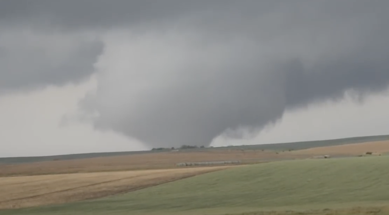
For example, this tornado I saw in KS a few years ago. Officially rated an EF1 (though again, it just didn't hit anything at peak intensity and was likely stronger which is why the EF scale is flawed):
-
Busguy2010
- City Council
- Posts: 7397
- Joined: Sun Apr 10, 2011 12:32 am
- Location: North Central Omaha
Re: 2025 Weather Thread
Well, you yourself even said you thought it'd end up EF-0 or EF-U. Now that you're saying it might be EF-3, based on the feeling you had while you were there, says that you can tell. The video you shared, it looked weak. The other video I saw of it looked like it could have been EF-2ish. I don't know, I wasn't there. Anyway, I wasn't trying to argue anything.
-
stormchaser
- Planning Board
- Posts: 2380
- Joined: Fri Jun 01, 2018 1:14 pm
Re: 2025 Weather Thread
I think you're confusing which tornado I'm referring to. The tornado that hit north of Omaha was likely an EF3 based on the damage I've seen (but that's just my opinion, who knows). Not based on the appearance of the tornado.Busguy2010 wrote: Fri Apr 18, 2025 8:52 pm Well, you yourself even said you thought it'd end up EF-0 or EF-U. Now that you're saying it might be EF-3, based on the feeling you had while you were there, says that you can tell. The video you shared, it looked weak. The other video I saw of it looked like it could have been EF-2ish. I don't know, I wasn't there. Anyway, I wasn't trying to argue anything.
The one I saw yesterday was probably an EF-1 (but that's just a guess and I could be completely wrong - we'll likely never know since I don't think it did any damage).
-
stormchaser
- Planning Board
- Posts: 2380
- Joined: Fri Jun 01, 2018 1:14 pm
Re: 2025 Weather Thread
I probably jumped your sh*t a little too quick - apologies. Understand though I've heard the same "mocking" from non-chasers for years so I'm probably overly sensitive to it but damn it's annoying sometimes because those people are never out there but feel the need to mock regardless. Little tornadoes sometimes turn into monsters QUICKLY so you just never know.Busguy2010 wrote: Fri Apr 18, 2025 8:52 pm Well, you yourself even said you thought it'd end up EF-0 or EF-U. Now that you're saying it might be EF-3, based on the feeling you had while you were there, says that you can tell. The video you shared, it looked weak. The other video I saw of it looked like it could have been EF-2ish. I don't know, I wasn't there. Anyway, I wasn't trying to argue anything.
-
Brad
- Photographer
- Posts: 1036702
- Joined: Sun Feb 29, 2004 12:03 am
- Location: Omaha, NE
Re: 2025 Weather Thread
Looks like you were correct the northern Douglas county tornado was rated and EF3.
Omaha Skyline Photos, Omaha Aerial Photos, and More.
Website: www.bradwilliamsphotography.com
Facebook: www.facebook.com/bradwilliamsphotography
Twitter: www.twitter.com/bradwphoto
Instagram: www.instagram.com/bradwilliamsphotography
YouTube: www.youtube.com/@bradwilliamsphoto