I got around to looking back.
Officially, it was two record highs, one in January, one in March. Add to that, this record warm low. However, I noticed several days within a degree or two of record high, so that's where I got my feel. Depending on your criteria, I say it adds up to about 10 days of record, or "record territory" warmth this year.
I certainly don't like to flirt with record warmth as often as we have this year. It ain't natural.
2025 Weather Thread
-
Busguy2010

- City Council
- Posts: 7398
- Joined: Sun Apr 10, 2011 12:32 am
- Location: North Central Omaha
-
GetUrban
- Planning Board
- Posts: 2650
- Joined: Sun Nov 23, 2008 9:07 pm
- Location: Omaha
Re: 2025 Weather Thread
All right. This blustery 100+ degree |expletive| is going to drive me crazy! Looking so forward to the cool down they say is on the way soon!
He said "They are some big, ugly red brick buildings"
...and then they were gone.
...and then they were gone.
-
Busguy2010
- City Council
- Posts: 7398
- Joined: Sun Apr 10, 2011 12:32 am
- Location: North Central Omaha
Re: 2025 Weather Thread
Somebody I know is in Duluth Minnesota, and its mid 50's and foggy. What a dream.
Its still gonna be fairly warm even after the "cool down"; upper 80's, lower 90's. But if we can knock 10-15 degrees off this heck on earth, I will not complain.
Its still gonna be fairly warm even after the "cool down"; upper 80's, lower 90's. But if we can knock 10-15 degrees off this heck on earth, I will not complain.
-
stormchaser
- Planning Board
- Posts: 2380
- Joined: Fri Jun 01, 2018 1:14 pm
Re: 2025 Weather Thread
Strong to severe storms are likely across parts of the area this afternoon and tonight with potential for heavy rain in parts of the area (though Omaha may miss out on much of it yet again - I explain below).
The primary severe weather risks are large hail and damaging wind. However, I believe there is at least some tornado threat - especially south of Omaha in an area from Fairbury, NE over to Nebraska City on south to the KS border where the low level jet will be stronger. However, hodographs from the area don't look great so the tornado risk will be very low but not impossible.
As I mentioned, Omaha may miss out yet again on much of the rain regardless of the going forecast. We'll get some rain but based on short range models, the majority of the heavy rain will pass south of Omaha. It'll all depend on where this boundary ends up thats just starting to push into the northwestern parts of the metro area now ends up later today/tonight. Chances are, it'll end up well south of Omaha and consequently, so will the storms/heavier rain.
Even if this first round misses us with the majority of the rain, thankfully there are plenty of other chances upcoming in the next several days.
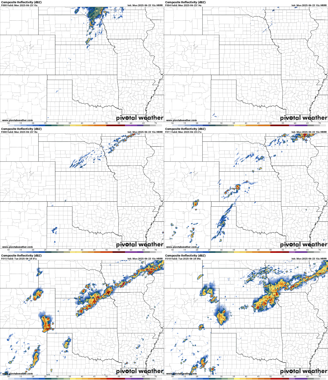
Here is a simulated radar of the latest HRRR run (10z) showing what I mean:
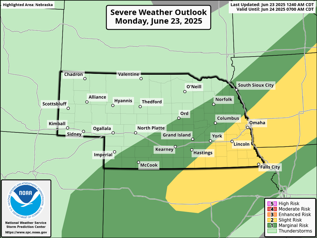
Otherwise, here is the severe weather risk area for today (as of 7 AM):
The primary severe weather risks are large hail and damaging wind. However, I believe there is at least some tornado threat - especially south of Omaha in an area from Fairbury, NE over to Nebraska City on south to the KS border where the low level jet will be stronger. However, hodographs from the area don't look great so the tornado risk will be very low but not impossible.
As I mentioned, Omaha may miss out yet again on much of the rain regardless of the going forecast. We'll get some rain but based on short range models, the majority of the heavy rain will pass south of Omaha. It'll all depend on where this boundary ends up thats just starting to push into the northwestern parts of the metro area now ends up later today/tonight. Chances are, it'll end up well south of Omaha and consequently, so will the storms/heavier rain.
Even if this first round misses us with the majority of the rain, thankfully there are plenty of other chances upcoming in the next several days.
Here is a simulated radar of the latest HRRR run (10z) showing what I mean:
Otherwise, here is the severe weather risk area for today (as of 7 AM):
-
stormchaser
- Planning Board
- Posts: 2380
- Joined: Fri Jun 01, 2018 1:14 pm
Re: 2025 Weather Thread
Some heavy rain should move through much of the area tonight/overnight tonight. Then attention will turn to the severe weather risk tomorrow. However, this risk is conditional and depends on what happens with the overnight/morning storms and cloud cover - in particular, where the threat will end up.
Chances are there will be some severe weather along a boundary in the area which includes all storm modes and consequently the risk will include large hail, damaging wind, and possibly a few tornadoes. Its just a matter of figuring out exactly where this boundary will be but probably somewhere relatively close to our area.
Chances are there will be some severe weather along a boundary in the area which includes all storm modes and consequently the risk will include large hail, damaging wind, and possibly a few tornadoes. Its just a matter of figuring out exactly where this boundary will be but probably somewhere relatively close to our area.
-
stormchaser
- Planning Board
- Posts: 2380
- Joined: Fri Jun 01, 2018 1:14 pm
Re: 2025 Weather Thread
Looks like the boundary pushed far enough north that Omaha will probably be missed by any severe weather later today/tonight with the risk mostly from around Columbus/Norfolk over to Sioux City and adjacent parts of northern IA/southern MN.
-
nebugeater

- City Council
- Posts: 111064
- Joined: Wed Aug 04, 2004 11:07 pm
- Location: Gretna NE
Re: 2025 Weather Thread
On Tuesday, around 6 PM, I dumped my Gauge in Gretna. This included the overnight rain on Monday Night and everything on Tuesday up to when I checked it. Had 2.4 inches
For the record NEBUGEATER does not equal BUGEATER !!!!!!!
-
BRoss

- IT Director
- Posts: 10003423
- Joined: Sat Aug 05, 2006 12:39 am
- Location: West Central Omaha
Re: 2025 Weather Thread
Wow, I got 1.47" here this week.nebugeater wrote: Wed Jun 25, 2025 1:42 pm On Tuesday, around 6 PM, I dumped my Gauge in Gretna. This included the overnight rain on Monday Night and everything on Tuesday up to when I checked it. Had 2.4 inches
-
skinzfan23
- City Council
- Posts: 11672
- Joined: Mon Feb 09, 2004 5:26 pm
- Location: Omaha/Bellevue
Re: 2025 Weather Thread
I got 1.6" just since 5 pm yesterday...2 day rain total of around 2.3" in Bellevue.
-
zippy
- Library Board
- Posts: 307
- Joined: Wed Mar 09, 2005 11:55 pm
- Location: Harvey Oaks
Re: 2025 Weather Thread
2.5" since Monday near Oakview
-
nebugeater
- City Council
- Posts: 111064
- Joined: Wed Aug 04, 2004 11:07 pm
- Location: Gretna NE
Re: 2025 Weather Thread
Another 0.5 dumped on Wed evening. Total at 2.9 now as of about 6 PM Wed.nebugeater wrote: Wed Jun 25, 2025 1:42 pm On Tuesday, around 6 PM, I dumped my Gauge in Gretna. This included the overnight rain on Monday Night and everything on Tuesday up to when I checked it. Had 2.4 inches
For the record NEBUGEATER does not equal BUGEATER !!!!!!!
-
stormchaser
- Planning Board
- Posts: 2380
- Joined: Fri Jun 01, 2018 1:14 pm
Re: 2025 Weather Thread
Based on the last several runs of the HRRR, the Omaha area and/or areas just east of town will be at risk for severe weather early this afternoon.
Regardless of what the current SPC outlook shows (which has the risk area in north central/northeast IA currently), our area will be at risk for large hail, damaging wind, and at least a couple of isolated tornadoes. Of course this all depends on timing of when the storms fire and when the front pushes through. If it holds off until mid to late afternoon with storms firing, then everything will likely be east of us.
We'll see if the SPC updates the risk area here shortly when they release a new updated outlook but even if it doesn't please remain weather aware today.
Regardless of what the current SPC outlook shows (which has the risk area in north central/northeast IA currently), our area will be at risk for large hail, damaging wind, and at least a couple of isolated tornadoes. Of course this all depends on timing of when the storms fire and when the front pushes through. If it holds off until mid to late afternoon with storms firing, then everything will likely be east of us.
We'll see if the SPC updates the risk area here shortly when they release a new updated outlook but even if it doesn't please remain weather aware today.
-
stormchaser
- Planning Board
- Posts: 2380
- Joined: Fri Jun 01, 2018 1:14 pm
Re: 2025 Weather Thread
Looks like they updated and still have the risk area mostly northeast of us. To clarify, I realize the risk is higher northeast of Omaha into north central/northeast IA, etc. I just think there is at least some localized threat in our area too so hopefully people keep an eye on it.
-
Cermak
- Planning Board
- Posts: 2350
- Joined: Thu Nov 29, 2018 7:02 pm
Re: 2025 Weather Thread
I was up in Valley Nebraska last evening around 6pm. Some pretty nasty looking storm clouds to the north but nothing much happened in Valley. Some cooler air did push through giving more comfortable temps.
-
nebugeater
- City Council
- Posts: 111064
- Joined: Wed Aug 04, 2004 11:07 pm
- Location: Gretna NE
Re: 2025 Weather Thread
Family and friends around Oakland NE were reporting 4" yesterday evening and overnight. They lost power for a while, too.Cermak wrote: Thu Jun 26, 2025 2:23 pm I was up in Valley Nebraska last evening around 6pm. Some pretty nasty looking storm clouds to the north but nothing much happened in Valley. Some cooler air did push through giving more comfortable temps.
For the record NEBUGEATER does not equal BUGEATER !!!!!!!
-
stormchaser
- Planning Board
- Posts: 2380
- Joined: Fri Jun 01, 2018 1:14 pm
Re: 2025 Weather Thread
Yep, storms just sat in that area and kept moving over the same area over and over again. Columbus and Grand Island got a bunch of rain too (over 6 inches in some areas).nebugeater wrote: Thu Jun 26, 2025 2:34 pmFamily and friends around Oakland NE were reporting 4" yesterday evening and overnight. They lost power for a while, too.Cermak wrote: Thu Jun 26, 2025 2:23 pm I was up in Valley Nebraska last evening around 6pm. Some pretty nasty looking storm clouds to the north but nothing much happened in Valley. Some cooler air did push through giving more comfortable temps.
-
Brad

- Photographer
- Posts: 1036702
- Joined: Sun Feb 29, 2004 12:03 am
- Location: Omaha, NE
Re: 2025 Weather Thread
Enough rain up north the Papio NRD is closing all the river access points on the Platte and Elkhorn.stormchaser wrote: Thu Jun 26, 2025 2:49 pmYep, storms just sat in that area and kept moving over the same area over and over again. Columbus and Grand Island got a bunch of rain too (over 6 inches in some areas).nebugeater wrote: Thu Jun 26, 2025 2:34 pm Family and friends around Oakland NE were reporting 4" yesterday evening and overnight. They lost power for a while, too.

Omaha Skyline Photos, Omaha Aerial Photos, and More.
Website: www.bradwilliamsphotography.com
Facebook: www.facebook.com/bradwilliamsphotography
Twitter: www.twitter.com/bradwphoto
Instagram: www.instagram.com/bradwilliamsphotography
YouTube: www.youtube.com/@bradwilliamsphoto
-
stormchaser
- Planning Board
- Posts: 2380
- Joined: Fri Jun 01, 2018 1:14 pm
Re: 2025 Weather Thread
Storms are just starting to fire in the area with a MD out for areas along and east of the MO river. Watch will likely be issued soon.
-
Busguy2010
- City Council
- Posts: 7398
- Joined: Sun Apr 10, 2011 12:32 am
- Location: North Central Omaha
Re: 2025 Weather Thread
Nice to see a couple nights of reasonable lows coming up. Into the 60's, might even be worth opening the windows.
-
almighty_tuna
- City Council
- Posts: 106415
- Joined: Tue Apr 13, 2004 6:34 pm
- Location: Somewhere between downtown and Colorado
Re: 2025 Weather Thread
This rain right now is nice and necessary, but I've got 32lbs of pork butt to get in the smoker and I can't even get the fire started because the rain storms keep redeveloping overhead!!

-
Louie
- County Board
- Posts: 4968
- Joined: Fri Dec 23, 2011 10:23 pm
- Location: Dundee
Re: 2025 Weather Thread
It is absolutely pouring where we are.
-
Brad
- Photographer
- Posts: 1036702
- Joined: Sun Feb 29, 2004 12:03 am
- Location: Omaha, NE
Re: 2025 Weather Thread
LOL!! We got 4 really nice rounds in Old Mill since I got to work.almighty_tuna wrote: Wed Jul 02, 2025 2:34 pm This rain right now is nice and necessary, but I've got 32lbs of pork butt to get in the smoker and I can't even get the fire started because the rain storms keep redeveloping overhead!!
Omaha Skyline Photos, Omaha Aerial Photos, and More.
Website: www.bradwilliamsphotography.com
Facebook: www.facebook.com/bradwilliamsphotography
Twitter: www.twitter.com/bradwphoto
Instagram: www.instagram.com/bradwilliamsphotography
YouTube: www.youtube.com/@bradwilliamsphoto
-
Busguy2010
- City Council
- Posts: 7398
- Joined: Sun Apr 10, 2011 12:32 am
- Location: North Central Omaha
Re: 2025 Weather Thread
A nice lil surprise. I watch both KETV and WOWT forecasts during any given news cast, and all the meteorologists I watched were all basically saying "eh, it ain't gonna happen". They sounded pretty confident of it. To turn up with that is quite nice.
Since the siren test just went off and the storm passed not that long ago, it had me wondering if they have a protocol about sounding the test during an actual storm. If that storm happened an hour and a half later, that really would have had people looking around. That'd have to be such a rare occurrence.
Since the siren test just went off and the storm passed not that long ago, it had me wondering if they have a protocol about sounding the test during an actual storm. If that storm happened an hour and a half later, that really would have had people looking around. That'd have to be such a rare occurrence.
-
skinzfan23
- City Council
- Posts: 11672
- Joined: Mon Feb 09, 2004 5:26 pm
- Location: Omaha/Bellevue
Re: 2025 Weather Thread
Still to this day....I refuse to watch when I see Caitlin Harvey on KETV. About 2-3 years ago, she "guaranteed" that we weren't going to get any snow and we ended up with 4-5". I have never heard a meteorologist ever use the words "guaranteed" and add in the fact that we indeed got the exact opposite of what she predicted, I just laugh every time I see her now.
-
stormchaser
- Planning Board
- Posts: 2380
- Joined: Fri Jun 01, 2018 1:14 pm
Re: 2025 Weather Thread
Scattered strong/severe storms will be possible today in much of NE with the main risk being west and north of Omaha. However, it's becoming increasingly likely Omaha will be impacted by some severe weather too (potentially anyway) - most likely sometime between 7 PM and 11 PM (with the most probable time around 9 PM). The main risks will be damaging wind/hail with some localized flooding issues as well.
-
stormchaser
- Planning Board
- Posts: 2380
- Joined: Fri Jun 01, 2018 1:14 pm
Re: 2025 Weather Thread
Severe storms approaching Omaha from the northwest. Wind damage possible as they move through the area in the next hour or so…
-
Busguy2010
- City Council
- Posts: 7398
- Joined: Sun Apr 10, 2011 12:32 am
- Location: North Central Omaha
Re: 2025 Weather Thread
Wow, quite the unexpectedly vigorous and early arriving storm. I wasnt expecting this level. Its legitimately a pretty strong bow echo.
-
Cermak
- Planning Board
- Posts: 2350
- Joined: Thu Nov 29, 2018 7:02 pm
Re: 2025 Weather Thread
Really nothing compared to the storm last July or the 2021 storm. But still somewhat impressive, I think I had some wind gust around 50 or so in my neighborhood.
-
Busguy2010
- City Council
- Posts: 7398
- Joined: Sun Apr 10, 2011 12:32 am
- Location: North Central Omaha
Re: 2025 Weather Thread
I was downtown right when it came through. It was quite the dust storm. Lots of people out walking, caught off guard. Every time I got stuck at a light down there, my vehicle was dancing around. Took Saddle Creek back. It wasnt flooded, but some considerable puddles. And between here and downtown, I saw quite a few intermediate sized branches down in the street.
I think the biggest factor of this one was the surprise.
I think the biggest factor of this one was the surprise.
-
Brad
- Photographer
- Posts: 1036702
- Joined: Sun Feb 29, 2004 12:03 am
- Location: Omaha, NE
Re: 2025 Weather Thread
If people were surprised, they don't pay attention to the forecast. Even the worthless weather channel got this one right.
-We were in the SPC outlook all day
-The local meteorologist I follow said between 9pm and 1am
-A Severe Thunderstorm watch for Omaha was issued almost an hour before the storms. There was a watch just to our north for several hours before Omaha's watch.
Rusty's forecast at noon yesterday
Omaha Skyline Photos, Omaha Aerial Photos, and More.
Website: www.bradwilliamsphotography.com
Facebook: www.facebook.com/bradwilliamsphotography
Twitter: www.twitter.com/bradwphoto
Instagram: www.instagram.com/bradwilliamsphotography
YouTube: www.youtube.com/@bradwilliamsphoto
-
Busguy2010
- City Council
- Posts: 7398
- Joined: Sun Apr 10, 2011 12:32 am
- Location: North Central Omaha
Re: 2025 Weather Thread
I only heard they included us in the slight risk. I didn't get around to actually watching the news yesterday, I'm off what they were saying on Sunday. They didn't raise much concern about it, hence why I didn't feel the need to watch it yesterday, and why I was surprised.
Yesterday was one out of a hundred that I didn't check the forecast.
Yesterday was one out of a hundred that I didn't check the forecast.
-
swinquest
- Home Owners Association
- Posts: 191
- Joined: Mon Mar 31, 2014 4:46 am
Re: 2025 Weather Thread
I think some of the issues is that there are so many computer models. I think one model on the news last night said it would be a couple of hours later than another model. Trying to figure out which one to believe and/or listen to is the challenge.
-
stormchaser
- Planning Board
- Posts: 2380
- Joined: Fri Jun 01, 2018 1:14 pm
Re: 2025 Weather Thread
Thats the world of forecasting though - something most people don't realize. Many seem to think a forecaster/meteorologist simply looks at a computer model (if that even) and can make a forecast that (in the public's mind anyway) "should" be 100% accurate at all times no matter what. Otherwise it's incompetence (which is ridiculous).swinquest wrote: Tue Jul 08, 2025 5:32 pm I think some of the issues is that there are so many computer models. I think one model on the news last night said it would be a couple of hours later than another model. Trying to figure out which one to believe and/or listen to is the challenge.
None of the models are 100% accurate (not even close) and some are better at certain conditions/scenarios than others. Plus they all have certain biases to be aware of.
They also have different resolutions based on what type of model you're looking at. For example, the short range models are generally high resolution and you can see a significant amount of detail as a result. However, the medium and long range models are lower resolution and you can only get a rough idea of what to expect usually and the further out you go in time, the less reliable they become since things work in a "for every action there is a reaction" sort of way when it comes to weather so if something changes or doesn't play out as expected, it will have consequences with what happens "down river" so to speak too.
To really understand what's happening when looking at these models, you need to look at the trends from run to run as well as agreement between the different models and do so on a regular/consistent basis. You also have to understand the biases and strengths/weaknesses of the models you're using. Once you see run to run consistency and good agreement between different models, "usually" you can be fairly confident in your forecast. Even then, however, we simply don't have the technology to get a realtime view of whats happening aloft in the various layers of the atmosphere. We only get short glimpses from when they do balloon launches so it isn't uncommon for something to happen/not happen (like a stronger cap than expected) that will ultimately completely change how the weather unfolds for the day.
All these things combined are only the beginning of really accurately forecasting what's going to happen. That's why it's so sad/pathetic the people out there who complain and act like weather forecasters are clueless idiots who should lose their jobs. They don't understand and they don't care to understand (usually).
-
Erik
- Parks & Recreation
- Posts: 1537
- Joined: Wed Sep 08, 2004 5:55 am
Re: 2025 Weather Thread
Part of the issue is how people mistake cynicism for intelligence. Granted, using cynicism as a form of communication gives an aura of cute, confident, high-horse piousness that many cannot decipher properly.stormchaser wrote: Tue Jul 08, 2025 6:13 pmThats the world of forecasting though - something most people don't realize. Many seem to think a forecaster/meteorologist simply looks at a computer model (if that even) and can make a forecast that (in the public's mind anyway) "should" be 100% accurate at all times no matter what. Otherwise it's incompetence (which is ridiculous).swinquest wrote: Tue Jul 08, 2025 5:32 pm I think some of the issues is that there are so many computer models. I think one model on the news last night said it would be a couple of hours later than another model. Trying to figure out which one to believe and/or listen to is the challenge.
None of the models are 100% accurate (not even close) and some are better at certain conditions/scenarios than others. Plus they all have certain biases to be aware of.
They also have different resolutions based on what type of model you're looking at. For example, the short range models are generally high resolution and you can see a significant amount of detail as a result. However, the medium and long range models are lower resolution and you can only get a rough idea of what to expect usually and the further out you go in time, the less reliable they become since things work in a "for every action there is a reaction" sort of way when it comes to weather so if something changes or doesn't play out as expected, it will have consequences with what happens "down river" so to speak too.
To really understand what's happening when looking at these models, you need to look at the trends from run to run as well as agreement between the different models and do so on a regular/consistent basis. You also have to understand the biases and strengths/weaknesses of the models you're using. Once you see run to run consistency and good agreement between different models, "usually" you can be fairly confident in your forecast. Even then, however, we simply don't have the technology to get a realtime view of whats happening aloft in the various layers of the atmosphere. We only get short glimpses from when they do balloon launches so it isn't uncommon for something to happen/not happen (like a stronger cap than expected) that will ultimately completely change how the weather unfolds for the day.
All these things combined are only the beginning of really accurately forecasting what's going to happen. That's why it's so sad/pathetic the people out there who complain and act like weather forecasters are clueless idiots who should lose their jobs. They don't understand and they don't care to understand (usually).
-
stormchaser
- Planning Board
- Posts: 2380
- Joined: Fri Jun 01, 2018 1:14 pm
Re: 2025 Weather Thread
Yep, I agree.Erik wrote: Wed Jul 09, 2025 8:23 amPart of the issue is how people mistake cynicism for intelligence. Granted, using cynicism as a form of communication gives an aura of cute, confident, high-horse piousness that many cannot decipher properly.stormchaser wrote: Tue Jul 08, 2025 6:13 pmThats the world of forecasting though - something most people don't realize. Many seem to think a forecaster/meteorologist simply looks at a computer model (if that even) and can make a forecast that (in the public's mind anyway) "should" be 100% accurate at all times no matter what. Otherwise it's incompetence (which is ridiculous).swinquest wrote: Tue Jul 08, 2025 5:32 pm I think some of the issues is that there are so many computer models. I think one model on the news last night said it would be a couple of hours later than another model. Trying to figure out which one to believe and/or listen to is the challenge.
None of the models are 100% accurate (not even close) and some are better at certain conditions/scenarios than others. Plus they all have certain biases to be aware of.
They also have different resolutions based on what type of model you're looking at. For example, the short range models are generally high resolution and you can see a significant amount of detail as a result. However, the medium and long range models are lower resolution and you can only get a rough idea of what to expect usually and the further out you go in time, the less reliable they become since things work in a "for every action there is a reaction" sort of way when it comes to weather so if something changes or doesn't play out as expected, it will have consequences with what happens "down river" so to speak too.
To really understand what's happening when looking at these models, you need to look at the trends from run to run as well as agreement between the different models and do so on a regular/consistent basis. You also have to understand the biases and strengths/weaknesses of the models you're using. Once you see run to run consistency and good agreement between different models, "usually" you can be fairly confident in your forecast. Even then, however, we simply don't have the technology to get a realtime view of whats happening aloft in the various layers of the atmosphere. We only get short glimpses from when they do balloon launches so it isn't uncommon for something to happen/not happen (like a stronger cap than expected) that will ultimately completely change how the weather unfolds for the day.
All these things combined are only the beginning of really accurately forecasting what's going to happen. That's why it's so sad/pathetic the people out there who complain and act like weather forecasters are clueless idiots who should lose their jobs. They don't understand and they don't care to understand (usually).
Also, way too many people fail to take responsibility for anything and always want to pass blame. They don't want to put any effort into ensuring they have the latest forecast information and/or checking to see if there are updates. They look once several days in advance and then get mad when what they saw didn't happen exactly as it said. Many also have no clue that the forecast on most apps doesn't actually come from a Meteorologist and is simply computer generated. While some day, this is probably how most forecasts will work, for the time being computer generated forecasts struggle with understanding biases, trends, etc (like I referenced above). Especially notifications saying the "rain will start in 2 hours" type messages - more often than not, the app can't tell the difference between ground clutter, virga, or false radar signals and actual/legit precip. Consequently, people think the "weather guy" is wrong when that happens which just isn't the case.
-
Brad
- Photographer
- Posts: 1036702
- Joined: Sun Feb 29, 2004 12:03 am
- Location: Omaha, NE
Re: 2025 Weather Thread
Could be said about most every issue in society these days... LOLstormchaser wrote: Wed Jul 09, 2025 2:42 pm Also, way too many people fail to take responsibility for anything and always want to pass blame.
Omaha Skyline Photos, Omaha Aerial Photos, and More.
Website: www.bradwilliamsphotography.com
Facebook: www.facebook.com/bradwilliamsphotography
Twitter: www.twitter.com/bradwphoto
Instagram: www.instagram.com/bradwilliamsphotography
YouTube: www.youtube.com/@bradwilliamsphoto
-
stormchaser
- Planning Board
- Posts: 2380
- Joined: Fri Jun 01, 2018 1:14 pm
Re: 2025 Weather Thread
lol unfortunatelyBrad wrote: Wed Jul 09, 2025 3:22 pmCould be said about most every issue in society these days... LOLstormchaser wrote: Wed Jul 09, 2025 2:42 pm Also, way too many people fail to take responsibility for anything and always want to pass blame.
-
Brad
- Photographer
- Posts: 1036702
- Joined: Sun Feb 29, 2004 12:03 am
- Location: Omaha, NE
Re: 2025 Weather Thread
Back to future weather... We are in the slight risk Today and Tomorrow
Today:
Tomorrow:
Today:
Tomorrow:
Omaha Skyline Photos, Omaha Aerial Photos, and More.
Website: www.bradwilliamsphotography.com
Facebook: www.facebook.com/bradwilliamsphotography
Twitter: www.twitter.com/bradwphoto
Instagram: www.instagram.com/bradwilliamsphotography
YouTube: www.youtube.com/@bradwilliamsphoto
-
stormchaser
- Planning Board
- Posts: 2380
- Joined: Fri Jun 01, 2018 1:14 pm
Re: 2025 Weather Thread
Doesn’t surprise me - night time damaging wind mostly at least our area.Brad wrote: Wed Jul 09, 2025 5:41 pm Back to future weather... We are in the slight risk Today and Tomorrow
Today:
Tomorrow:
Friday shows higher potential in our local area IMO but depends on timing/storm track
-
stormchaser
- Planning Board
- Posts: 2380
- Joined: Fri Jun 01, 2018 1:14 pm
Re: 2025 Weather Thread
Damaging wind, hail and a few tornadoes will be possible today in parts of the area including the Omaha area.
Currently it looks like the most likely area to see a threat for tornadoes is northwest of Omaha around O'Neill, Norfolk, Wayne, NE down towards Columbus and over towards Missouri Valley, IA this afternoon into early this evening.
The main threat in Omaha itself will be this evening with mostly a damaging wind/hail threat though an isolated tornado can't be ruled out as the storms expected to develop in the aforementioned areas move southeast towards Omaha.
Please remain weather aware today.
Currently it looks like the most likely area to see a threat for tornadoes is northwest of Omaha around O'Neill, Norfolk, Wayne, NE down towards Columbus and over towards Missouri Valley, IA this afternoon into early this evening.
The main threat in Omaha itself will be this evening with mostly a damaging wind/hail threat though an isolated tornado can't be ruled out as the storms expected to develop in the aforementioned areas move southeast towards Omaha.
Please remain weather aware today.