Omaha Cowboy wrote: Wed Jun 10, 2020 3:41 pm
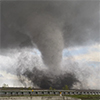
That kind of looks like a funnel and tornado touchdown to my untrained eye..
Great Pic stormchaser!...
Ciao..LiO...Peace
Thanks Omaha Cowboy!
You’re welcome!..
Any predictions for the next potential severe weather threat for the Omaha area?...
Ciao..LiO...Peace
Overall weather pattern looks quiet for the time being. "Maybe" an isolated storm or 2 this weekend and early next week but definitely not anything widespread. Then relatively hot into next week which typically pushes the storm threats to our north. Things typically change quickly though but for the most part, I'd expect calm weather for at least the next week or so overall. Things "might" start getting more active again late next week/the following weekend but that's too far out yet to really be all that reliable
Omaha Cowboy wrote: Wed Jun 10, 2020 3:41 pm
That kind of looks like a funnel and tornado touchdown to my untrained eye..
Great Pic stormchaser!...
Ciao..LiO...Peace
Thanks Omaha Cowboy!
You’re welcome!..
Any predictions for the next potential severe weather threat for the Omaha area?...
Ciao..LiO...Peace
Overall weather pattern looks quiet for the time being. "Maybe" an isolated storm or 2 this weekend and early next week but definitely not anything widespread. Then relatively hot into next week which typically pushes the storm threats to our north. Things typically change quickly though but for the most part, I'd expect calm weather for at least the next week or so overall. Things "might" start getting more active again late next week/the following weekend but that's too far out yet to really be all that reliable
Cool. Thanks for the update. I know predicting the weather is difficult and extremely fluid, but it’ll be nice to see some calm weather for the next week or so..Realizing it is June in Omaha and usually a very active weather month ...
Omaha Cowboy wrote: Wed Jun 10, 2020 3:41 pm
That kind of looks like a funnel and tornado touchdown to my untrained eye..
Great Pic stormchaser!...
Ciao..LiO...Peace
Thanks Omaha Cowboy!
You’re welcome!..
Any predictions for the next potential severe weather threat for the Omaha area?...
Ciao..LiO...Peace
Overall weather pattern looks quiet for the time being. "Maybe" an isolated storm or 2 this weekend and early next week but definitely not anything widespread. Then relatively hot into next week which typically pushes the storm threats to our north. Things typically change quickly though but for the most part, I'd expect calm weather for at least the next week or so overall. Things "might" start getting more active again late next week/the following weekend but that's too far out yet to really be all that reliable
Cool. Thanks for the update. I know predicting the weather is difficult and extremely fluid, but it’ll be nice to see some calm weather for the next week or so..Realizing it is June in Omaha and usually a very active weather month ...
Ciao..LiO...Peace
Yep, no problem - happy to help!
So since it's relatively quiet, here is a list of some of the resources I use for nowcasting/forecasting severe weather (in case anyone is interested):
https://www.spc.noaa.gov/sfctest/new/vi ... 1&source=1 - used for nowcasting/forecasting during the "day of". Shows detailed parameters that I use to determine exact locations of where severe weather/tornadoes will likely occur.
https://www.spc.noaa.gov/exper/soundings/ - Observed soundings (weather balloon launches) from each local NWS office. Again, useful for nowcasting including determining the likely strength of any capping, lower level wind fields, etc
Obviously there are others but this is a good solid list to get people started. Of course most of the links require some forecasting knowledge (but not all do) .
Omaha Cowboy wrote: Wed Jun 10, 2020 3:41 pm
That kind of looks like a funnel and tornado touchdown to my untrained eye..
Great Pic stormchaser!...
Ciao..LiO...Peace
Thanks Omaha Cowboy!
You’re welcome!..
Any predictions for the next potential severe weather threat for the Omaha area?...
Ciao..LiO...Peace
Overall weather pattern looks quiet for the time being. "Maybe" an isolated storm or 2 this weekend and early next week but definitely not anything widespread. Then relatively hot into next week which typically pushes the storm threats to our north. Things typically change quickly though but for the most part, I'd expect calm weather for at least the next week or so overall. Things "might" start getting more active again late next week/the following weekend but that's too far out yet to really be all that reliable
Cool. Thanks for the update. I know predicting the weather is difficult and extremely fluid, but it’ll be nice to see some calm weather for the next week or so..Realizing it is June in Omaha and usually a very active weather month ...
Ciao..LiO...Peace
Yep, no problem - happy to help!
So since it's relatively quiet, here is a list of some of the resources I use for nowcasting/forecasting severe weather (in case anyone is interested):
https://www.spc.noaa.gov/sfctest/new/vi ... 1&source=1 - used for nowcasting/forecasting during the "day of". Shows detailed parameters that I use to determine exact locations of where severe weather/tornadoes will likely occur.
https://www.spc.noaa.gov/exper/soundings/ - Observed soundings (weather balloon launches) from each local NWS office. Again, useful for nowcasting including determining the likely strength of any capping, lower level wind fields, etc
Obviously there are others but this is a good solid list to get people started. Of course most of the links require some forecasting knowledge (but not all do) .
Definitely looking like our next main risk for severe weather/potential tornadoes will be next Friday (June 19th). It’s way too far out to be confident though...
Actually scratch that, looks like Thursday along a cold front will be the next severe weather threat in the area. Looks like predominantly a damaging wind/hail threat though (but an isolated tornado threat will probably exist as well). I’d expect several more rounds of storms/potential severe weather for several days after as well but exact locations will depend on boundary locations. Either way, probably going to get more active again soon - with some much needed rain across the area as well...
Here is the simulated radar for the next few days across the area based on the 12z 3km NAM which shows potential severe storms in parts of central Nebraska Wednesday afternoon/evening and then possible severe weather along a cold front pushing through our area on Thursday (shown toward the very end of the animation). Timing of how quickly this cold front pushes through will dictate if Omaha will get potential severe storms or not on Thursday but right now the main potential is probably east of here (though things can obviously change/slow down yet).
stormchaser wrote: Tue Jun 16, 2020 7:18 pm
Here is the simulated radar for the next few days across the area based on the 12z 3km NAM which shows potential severe storms in parts of central Nebraska Wednesday afternoon/evening and then possible severe weather along a cold front pushing through our area on Thursday (shown toward the very end of the animation). Timing of how quickly this cold front pushes through will dictate if Omaha will get potential severe storms or not on Thursday but right now the main potential is probably east of here (though things can obviously change/slow down yet).
I’ll definitely keep my eyes on the sky Thursday afternoon/evening...
I bet you it's a miss. Hopefully it will come through with some rain, at least. Hard to believe our severe season is nearing its end without much to speak of AGAIN. If nothing changes in the next two weeks, this will be the third consecutive snoozer of a severe season for the books in Omaha.
Busguy2010 wrote: Wed Jun 17, 2020 1:32 am
I bet you it's a miss. Hopefully it will come through with some rain, at least. Hard to believe our severe season is nearing its end without much to speak of AGAIN. If nothing changes in the next two weeks, this will be the third consecutive snoozer of a severe season for the books in Omaha.
Yeah, it definitely slows down after June anyway but I'm still hopeful things will get active at some point in the next couple of months. On average we still get tornadoes all the way into October - I've personally managed to see tornadoes every month except for December, January and February. Who knows though, certainly been pretty boring so far for storms anyway.
Things have slowed down for Thursday (not surprisingly) putting our area more at risk. Probably not going to be a substantial severe weather event but still should be some stronger storms in the area with some hail/damaging wind. Exact locations of the highest risk of severe weather will be dependent on what happens tonight with the storms and how far east/south outflow boundaries from those storms push and exactly where the front ends up.
Below is the simulated radar from the latest 3km NAM forecast models showing storms developing down near Beatrice around 4PM tomorrow and pushing up into our area. Early on in development is probably where the highest risk of severe weather will occur before things transition into a localized heavy rain event - at least for some people in the area (not everyone will get heavy rain out of this)...
NUub wrote: Wed Jun 17, 2020 8:58 pm
At the very least, looking forward to some better temperatures and a break from the wind!
Definitely.
In Omaha itself it looks like the primary window for isolated strong/severe storms will be between 5PM and 8PM this evening with a few isolated showers/storms starting in the area as early as 3PM (with the threat slightly earlier north of town). The main threat will be hail/damaging wind with these storms though the risk is pretty marginal for the most part. Otherwise this will mostly be a heavy rain event for the area...
Below is the 06z HRRR starting at 1PM until 10PM showing most of the storms moving into the area right around 6-7PM.
NUub wrote: Thu Jun 18, 2020 5:12 pm
Will this blunt the extremity of any later severe weather? I'm sure the rain is coming one way or another which is fine by me.
I wouldn't be surprised if there are a few isolated warnings for hail in the area but it shouldn't be anything wide spread anyway. The main limiting factor with the severe potential today is the lack of adequate wind shear along and ahead of the cold front. As a result, storms that develop will have a difficult time sustaining themselves and instead will "pulse up" in strength and then weaken almost as quickly.
That said, flooding in the Omaha area is starting to become a major concern. The last several runs of the HRRR forecast model (which is typically fairly accurate) has shown 3 inches to as much as 5 or 6 inches of rain in the Omaha area tonight as storms develop and then keep "training" (or moving) over the same area over and over again for several hours. This band will likely be fairly narrow but has been consistently depicted right on top of or very near the Omaha area. Regardless its something to watch as wherever this band sets up will likely see flooding. Definitely going to want to check that the sump pump is working ...
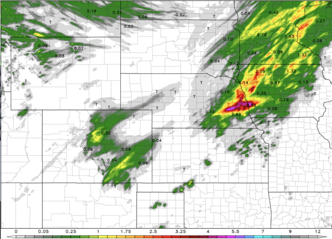
Below show the precip totals through 4AM tomorrow morning based on the latest HRRR forecast model - with rain still falling in the area at that time.
Last edited by stormchaser on Thu Jun 18, 2020 5:59 pm, edited 2 times in total.
Barely anything happened in Omaha, so I'd think as long as the temperature still gets up there like it's supposed to, I'd still expect it to be what it was predicted earlier. The small rain is practically totally evaporated already where I'm at so the humidity is definitely still there, just need the heat now.
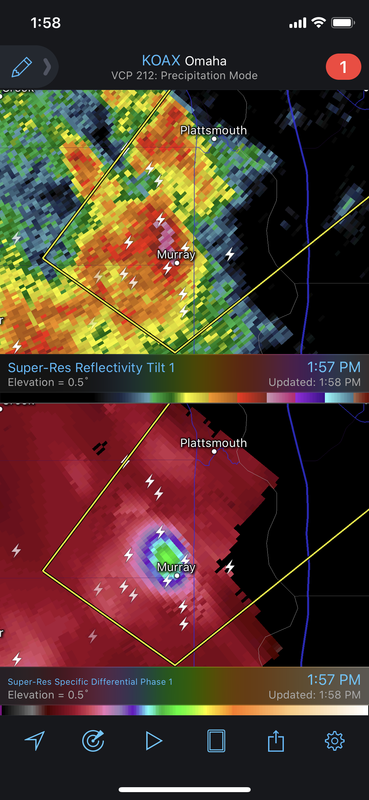
Severe thunderstorm warning for just south of Omaha for quarter size hail and winds of 65mph. Pretty obvious little hail core showing up moving near Murray currently...
The OmaDome strikes again! Well, we did get a little something, but not near what was just to our north and south. At least we got a healthy amount of rain. What little promise for actual storms that was coming up I-80 dissolved before it got here Again.
Busguy2010 wrote: Fri Jun 19, 2020 12:06 am
The OmaDome strikes again! Well, we did get a little something, but not near what was just to our north and south. At least we got a healthy amount of rain. What little promise for actual storms that was coming up I-80 dissolved before it got here Again.
Yeah, lame. Storms fired early and consequently pushed the better storms south some. That said, we probably aren’t completely done yet with storms in Omaha, just in a lull.
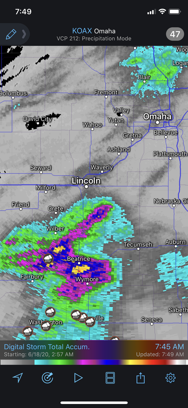
Obviously the heaviest rain missed Omaha with areas down near Beatrice getting 7"-8" (radar indicated anyway) worth of rain last night...
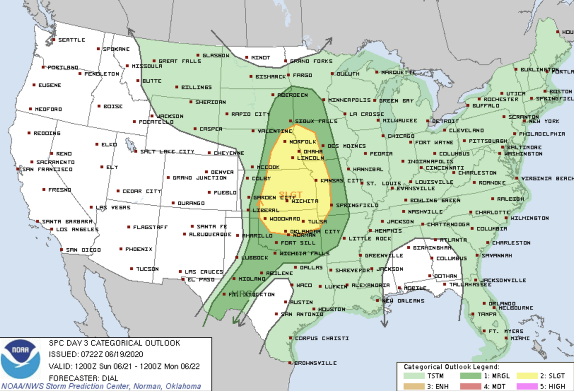
Next risk of severe weather appears to be this coming Sunday with what will likely be a damaging wind event - possibly in the evening or even after dark across much of the area. SPC has an outlook out already for Sunday including our area.
Looks like we're in for more rain Saturday too, just not the severe type. This is much more interesting than the hot & windy we've had for the past week. Seems like forever since I've seen a really ominous setup around here like what seemed to happen all the time when I was a kid!
NUub wrote: Fri Jun 19, 2020 3:36 pm
Looks like we're in for more rain Saturday too, just not the severe type. This is much more interesting than the hot & windy we've had for the past week. Seems like forever since I've seen a really ominous setup around here like what seemed to happen all the time when I was a kid!
Indeed. If you're just sitting at home, your usual Omahan hasn't seen one of those storms since 2016. Whereas leading up to that year, we had two, sometimes three of those storms roll through each year. I know for a fact the sirens haven't gone off in 2019 or 2018. Can't recall if they did in 2017. Have yet to hear them in 2020. Nonetheless, it's been a long stretch of yawning.
stormchaser wrote: Fri Jun 19, 2020 12:53 pm
Obviously the heaviest rain missed Omaha with areas down near Beatrice getting 7"-8" (radar indicated anyway) worth of rain last night...
Next risk of severe weather appears to be this coming Sunday with what will likely be a damaging wind event - possibly in the evening or even after dark across much of the area. SPC has an outlook out already for Sunday including our area.
Looks like Sunday is going to be active in the Omaha area Sunday afternoon/evening..
Will definitely pay attention to the sky for sure...
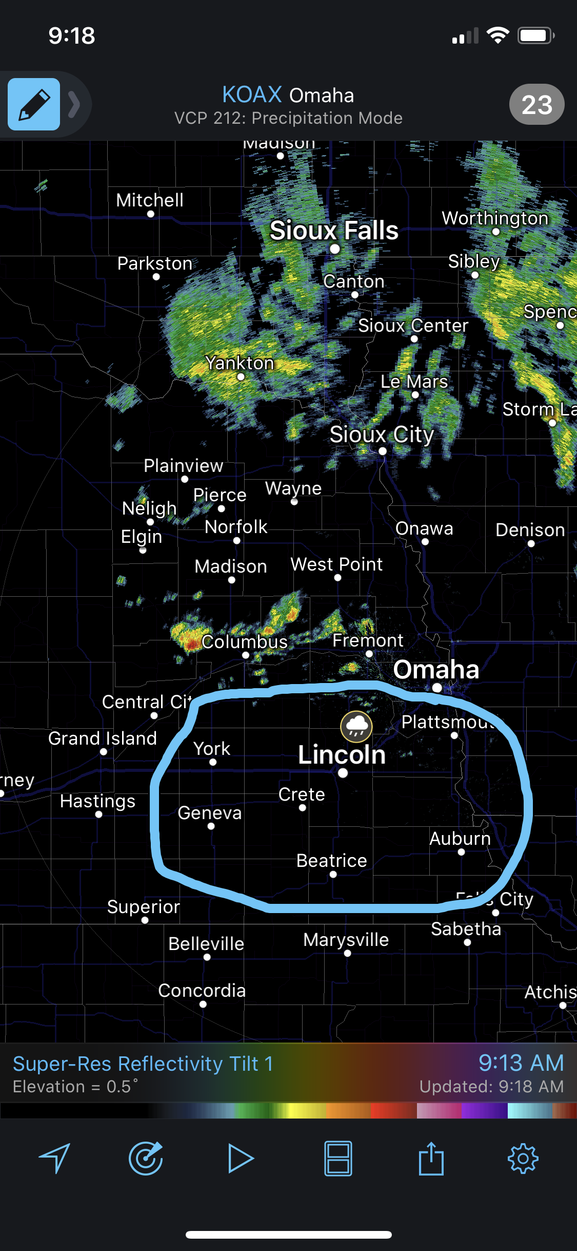
Heads up in the area outlined below late this morning and/or early this afternoon. Short range forecast models have been consistently showing a storm or 2 developing in this area. Based on current parameters, this storm (if it actually fires) would have the potential to become strong/severe and possibly supercellular. If it does, large hail and an isolated tornado would be possible (albeit very low risk) in the outlined area - probably somewhere near Lincoln will have the highest potential IF a storm fires soon.
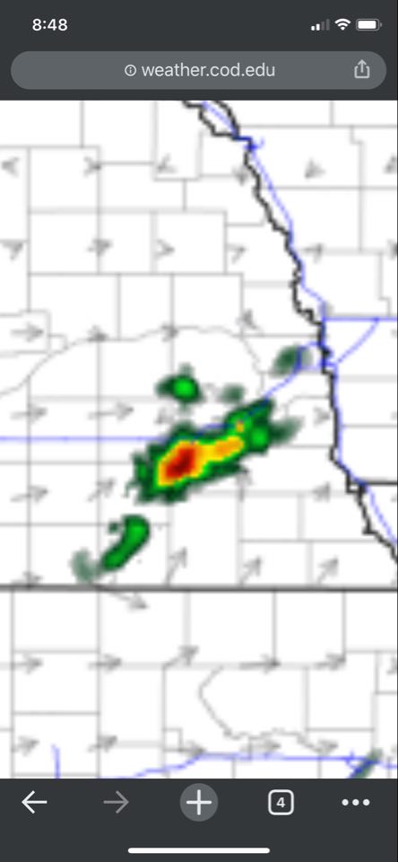
A couple little storms tried to get going south of Omaha yesterday but ultimately just not enough instability/forcing for them to fully develop. Oh well though. Today should be more interesting. I'll post simulated radar and my thoughts here in a couple hours once I can review more data, etc.
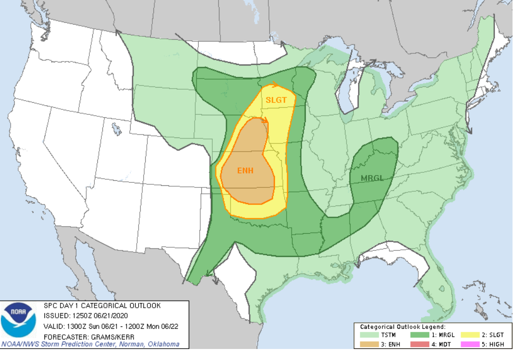
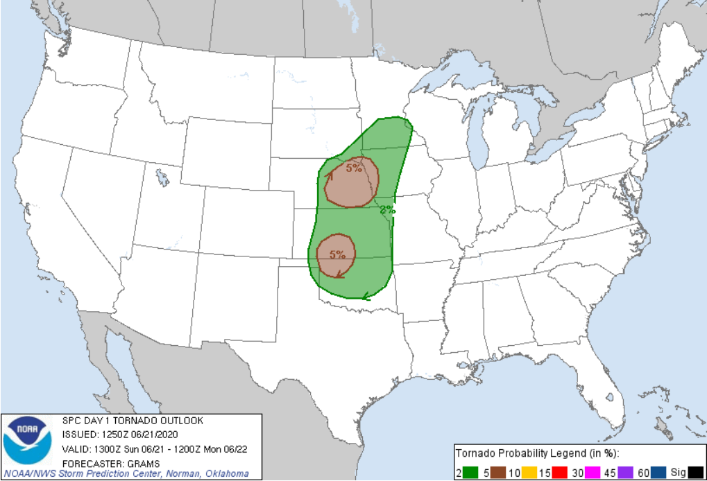
Looks like the SPC has bumped us up to an "enhanced risk" for severe weather in eastern Nebraska. Still primarily a damaging wind/hail (especially hail) event today but a few tornadoes look possible. Especially somewhere around Norfolk, NE (roughly) based on model guidance and the mesoanalysys.
Tornado risk:
12z HRRR forecast model showing the storms firing around 4PM in the Norfolk area where they may be tornadic initially and then dropping southeast and becoming more of a wind/hail producer as they move into the Omaha around around 6 or 7 (timing can of course change). If things verify as shown, these may produce very large hail - possibly baseball sized in the area.
It’s also worth noting these morning storms moving into the area may keep Omaha itself safe from severe potential later on as the storms later may weaken as they move into our area if the atmosphere doesn’t recover in time. So long story short, areas north and west of Omaha have the greatest severe weather potential today...
Too bad they are fizzling out, would have been fine with just two rain events today to get a good deep soak into the first week of summer. Will have to keep an eye on new hrrr runs now.
NUub wrote: Sun Jun 21, 2020 4:17 pm
Too bad they are fizzling out, would have been fine with just two rain events today to get a good deep soak into the first week of summer. Will have to keep an eye on new hrrr runs now.
Ehh, I’m glad this first round fizzled (as expected). Hopefully the atmosphere recovers in time. Still looking like a pretty healthy damaging wind/hail event to our northwest with a few isolated tornadoes but storms still look like they may die out as they approach Omaha...
NUub wrote: Sun Jun 21, 2020 4:17 pm
Too bad they are fizzling out, would have been fine with just two rain events today to get a good deep soak into the first week of summer. Will have to keep an eye on new hrrr runs now.
Ehh, I’m glad this first round fizzled (as expected). Hopefully the atmosphere recovers in time. Still looking like a pretty healthy damaging wind/hail event to our northwest with a few isolated tornadoes but storms still look like they may die out as they approach Omaha...
NUub wrote: Sun Jun 21, 2020 4:17 pm
Too bad they are fizzling out, would have been fine with just two rain events today to get a good deep soak into the first week of summer. Will have to keep an eye on new hrrr runs now.
Ehh, I’m glad this first round fizzled (as expected). Hopefully the atmosphere recovers in time. Still looking like a pretty healthy damaging wind/hail event to our northwest with a few isolated tornadoes but storms still look like they may die out as they approach Omaha...
That big batch in C KS is blocking our moisture!
Unfortunately - still enough for initiation near Norfolk though. Will be interesting to see if any of these can rotate. Low level shear/helicity look pretty meh currently
Yep. Omaha dodges yet another severe weather bullet..
Pretty incredible to see a 3rd consecutive year where Omaha is spared. I know, however, we’re only sitting at June 21st so anything can happen. But our most active severe weather month is almost in the books...
Omaha Cowboy wrote: Mon Jun 22, 2020 3:53 am
Yep. Omaha dodges yet another severe weather bullet..
Pretty incredible to see a 3rd consecutive year where Omaha is spared. I know, however, we’re only sitting at June 21st so anything can happen. But our most active severe weather month is almost in the books...
Ciao..LiO...Peace
Might have been last year or the year before, there was a severe storm that came through on July 4th. July 4th is kind of my personal severe weather bookmark. Once that passes, you can almost bet your house that there will be nothing to really speak of. Got 2 weeks ahead of us, though. Then again, our chances go up when fall comes through. Can't forget that October 4th Wayne monster tornado from 2013,
Omaha Cowboy wrote: Mon Jun 22, 2020 3:53 am
Yep. Omaha dodges yet another severe weather bullet..
Pretty incredible to see a 3rd consecutive year where Omaha is spared. I know, however, we’re only sitting at June 21st so anything can happen. But our most active severe weather month is almost in the books...
Ciao..LiO...Peace
Might have been last year or the year before, there was a severe storm that came through on July 4th. July 4th is kind of my personal severe weather bookmark. Once that passes, you can almost bet your house that there will be nothing to really speak of. Got 2 weeks ahead of us, though. Then again, our chances go up when fall comes through. Can't forget that October 4th Wayne monster tornado from 2013,
Yeah, I can't remember a year where every time something could go wrong with a setup it does. Yesterday really had two main issues. The storms that came through the Omaha area (west of town) early in the day produced an outflow boundary that pushed west/northwest away from the storms across much of eastern NE early/mid-afternoon. This outflow boundary triggered severe storm development in far northeast NE that moved into northwest IA. However, this outflow boundary also stabilized the atmosphere in much of eastern NE and combined with a persistent cloud deck in the area, it never fully recovered so storms that tried to develop struggled to really strengthen past a certain point. In addition, a large area of rain developed in northeast KS that at least to a extent cut off the moisture feeding into these storms. Neither scenario was expected and is an example of why forecasting things can be so difficult. 1 or 2 things change and that can COMPLETELY change how things play out.


 ...




 Again.
 [/url]