Lol - that's funny - oh well though I guessthenewguy wrote: Wed Apr 24, 2024 2:36 pmlol. For what it's worth, i actually said "holy c-r-a-p" and it expletive'd itstormchaser wrote: Wed Apr 24, 2024 12:56 pmNo problem - happy to help!thenewguy wrote: Wed Apr 24, 2024 7:39 am @stormchaser...
holy |expletive|, that's a fantastic explanation, thank you!! I've always been fascinated by weather, as many of us are, it's awesome to get some insight as to what you all talk about!
I 100% agree!Brad wrote: Wed Apr 24, 2024 8:54 am I have watched a lot of skew-t videos over the years and this one is still the best out there. Also, for those of you that liked his video, that was only part 1 of a 17 video series.![]()
2024 Weather Thread
-
stormchaser
- Planning Board
- Posts: 2380
- Joined: Fri Jun 01, 2018 8:14 am
Re: 2024 Weather Thread
-
stormchaser
- Planning Board
- Posts: 2380
- Joined: Fri Jun 01, 2018 8:14 am
Re: 2024 Weather Thread
The 00z HRRR is in and it continues the threat for severe and potentially tornadic storms in the local area Friday.
I’d be surprised if they don’t upgrade to an “enhanced risk” in or near the local area with the next severe weather outlook update from the SPC - with the highest tornado threat setting up very close to Omaha itself and into adjacent parts of western IA (and possibly to the west/northwest of Omaha or wherever the exact placement of the low ends up).
If storms can remain discrete enough, this “could” be a dangerous day. Still plenty of uncertainty though but hopefully people keep a close eye on it.
Needless to say, I plan on chasing Friday.
I’d be surprised if they don’t upgrade to an “enhanced risk” in or near the local area with the next severe weather outlook update from the SPC - with the highest tornado threat setting up very close to Omaha itself and into adjacent parts of western IA (and possibly to the west/northwest of Omaha or wherever the exact placement of the low ends up).
If storms can remain discrete enough, this “could” be a dangerous day. Still plenty of uncertainty though but hopefully people keep a close eye on it.
Needless to say, I plan on chasing Friday.
-
thenewguy
- County Board
- Posts: 4329
- Joined: Fri Oct 19, 2007 9:50 pm
- Location: Council Bluffs
Re: 2024 Weather Thread
my worry is straight line winds and hail. Is this gonna be more of a rain maker and thunder (aside from tornado risk) or will we have possible large hailstormchaser wrote: Wed Apr 24, 2024 9:10 pm The 00z HRRR is in and it continues the threat for severe and potentially tornadic storms in the local area Friday.
I’d be surprised if they don’t upgrade to an “enhanced risk” in or near the local area with the next severe weather outlook update from the SPC - with the highest tornado threat setting up very close to Omaha itself and into adjacent parts of western IA (and possibly to the west/northwest of Omaha or wherever the exact placement of the low ends up).
If storms can remain discrete enough, this “could” be a dangerous day. Still plenty of uncertainty though but hopefully people keep a close eye on it.
Needless to say, I plan on chasing Friday.
Go Cubs Go
-
stormchaser
- Planning Board
- Posts: 2380
- Joined: Fri Jun 01, 2018 8:14 am
Re: 2024 Weather Thread
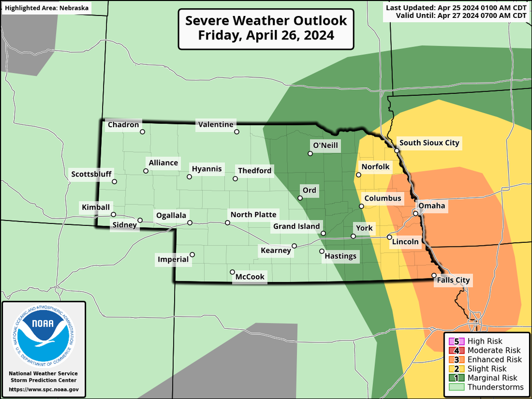
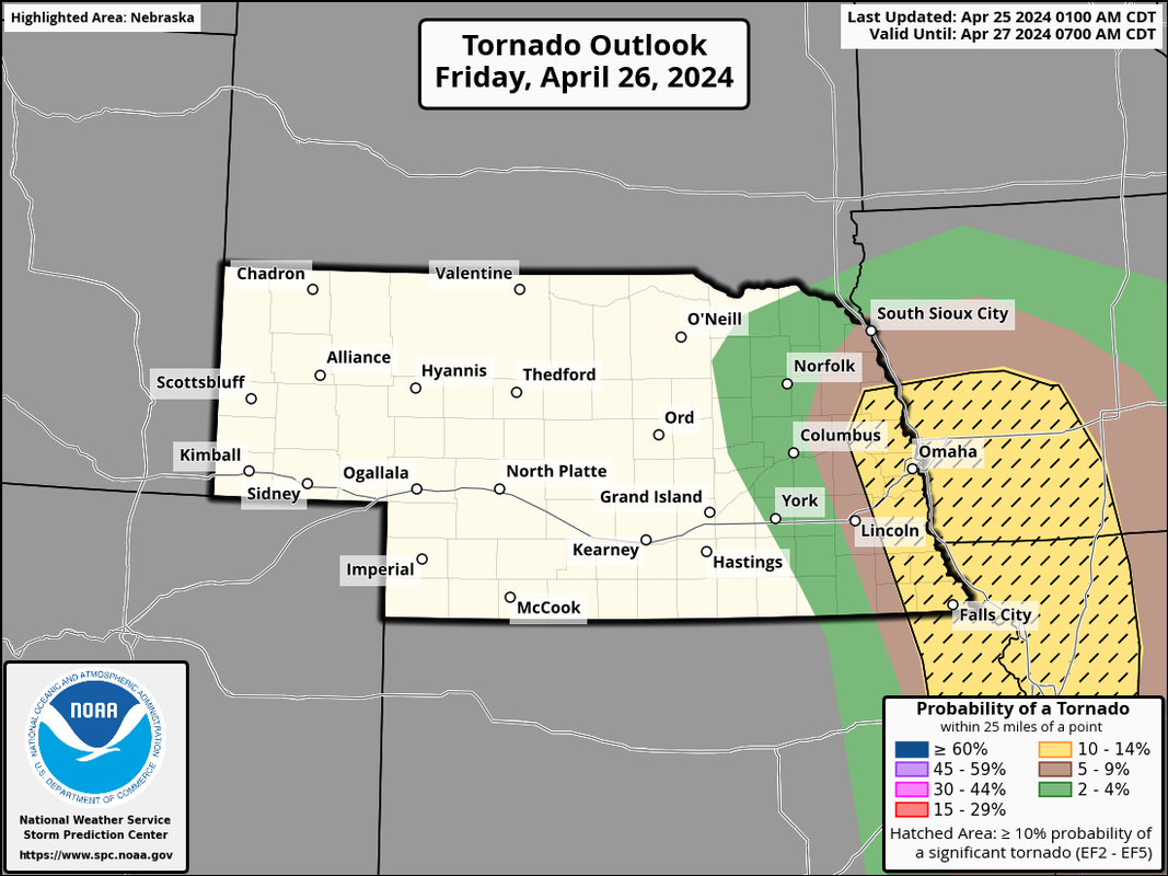
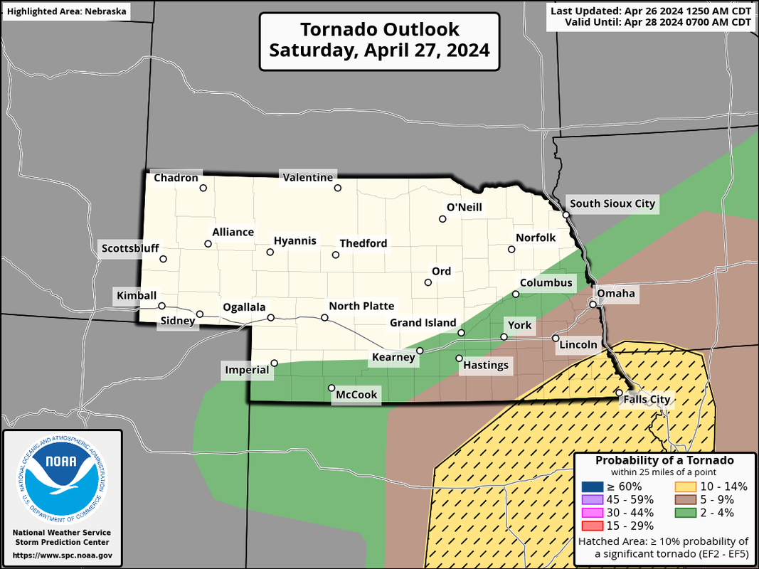
As expected the NWS has upgraded our area to an "enhanced risk" with a 10% tornado risk area that includes Omaha.


-
stormchaser
- Planning Board
- Posts: 2380
- Joined: Fri Jun 01, 2018 8:14 am
Re: 2024 Weather Thread
There will definitely be the potential for damaging wind and large/very large hail - especially with any supercells that develop.thenewguy wrote: Thu Apr 25, 2024 7:02 ammy worry is straight line winds and hail. Is this gonna be more of a rain maker and thunder (aside from tornado risk) or will we have possible large hailstormchaser wrote: Wed Apr 24, 2024 9:10 pm The 00z HRRR is in and it continues the threat for severe and potentially tornadic storms in the local area Friday.
I’d be surprised if they don’t upgrade to an “enhanced risk” in or near the local area with the next severe weather outlook update from the SPC - with the highest tornado threat setting up very close to Omaha itself and into adjacent parts of western IA (and possibly to the west/northwest of Omaha or wherever the exact placement of the low ends up).
If storms can remain discrete enough, this “could” be a dangerous day. Still plenty of uncertainty though but hopefully people keep a close eye on it.
Needless to say, I plan on chasing Friday.
-
Brad
- Photographer
- Posts: 1036554
- Joined: Sat Feb 28, 2004 6:03 pm
- Location: Omaha, NE
Re: 2024 Weather Thread
I was noticing this morning that the hatched area for hail is quite significant too.stormchaser wrote: Thu Apr 25, 2024 7:56 amThere will definitely be the potential for damaging wind and large/very large hail - especially with any supercells that develop.thenewguy wrote: Thu Apr 25, 2024 7:02 am
my worry is straight line winds and hail. Is this gonna be more of a rain maker and thunder (aside from tornado risk) or will we have possible large hail
Storm Prediction Center wrote:...SUMMARY...
An active severe weather day appears possible on Friday from parts
of Nebraska and Iowa southward into parts of the southern Great
Plains and Ozarks. A few tornadoes (possibly strong), large to very
large hail, and damaging winds will all be possible.
You do not have the required permissions to view the files attached to this post.

Omaha Skyline Photos, Omaha Aerial Photos, and More.
Website: www.bradwilliamsphotography.com
Facebook: www.facebook.com/bradwilliamsphotography
Twitter: www.twitter.com/bradwphoto
Instagram: www.instagram.com/bradwilliamsphotography
YouTube: www.youtube.com/@bradwilliamsphoto
-
stormchaser
- Planning Board
- Posts: 2380
- Joined: Fri Jun 01, 2018 8:14 am
Re: 2024 Weather Thread
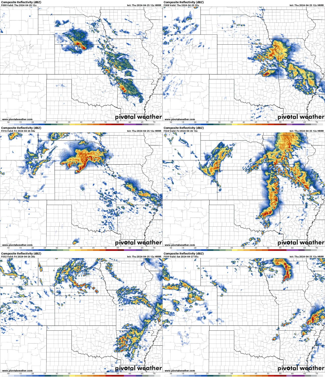
Below is an animation of the simulated radar from the 12z HRRR from now into tomorrow evening.
It continues to looks like we will have at least some risk for a damaging wind event late tonight/early tomorrow and then supercell development occurring tomorrow afternoon and moving directly through the Omaha area.
As I've mentioned a few times, this continues to look like potentially a dangerous day for the local area. Also, as I've mentioned a few times, if these storms can remain discrete enough, a stronger tornado or 2 would be possible somewhere in or near the local area. Not trying to overly hype things or scare anyone - just letting people know of the potential at least.
The time frame of the highest risk in the local area looks like it'll be between 3 PM and 7 PM tomorrow.

It continues to looks like we will have at least some risk for a damaging wind event late tonight/early tomorrow and then supercell development occurring tomorrow afternoon and moving directly through the Omaha area.
As I've mentioned a few times, this continues to look like potentially a dangerous day for the local area. Also, as I've mentioned a few times, if these storms can remain discrete enough, a stronger tornado or 2 would be possible somewhere in or near the local area. Not trying to overly hype things or scare anyone - just letting people know of the potential at least.
The time frame of the highest risk in the local area looks like it'll be between 3 PM and 7 PM tomorrow.

-
Brad
- Photographer
- Posts: 1036554
- Joined: Sat Feb 28, 2004 6:03 pm
- Location: Omaha, NE
Re: 2024 Weather Thread
The latest update just came out and the 10% / Hatched area area has been extended a little further west
You do not have the required permissions to view the files attached to this post.

Omaha Skyline Photos, Omaha Aerial Photos, and More.
Website: www.bradwilliamsphotography.com
Facebook: www.facebook.com/bradwilliamsphotography
Twitter: www.twitter.com/bradwphoto
Instagram: www.instagram.com/bradwilliamsphotography
YouTube: www.youtube.com/@bradwilliamsphoto
-
stormchaser
- Planning Board
- Posts: 2380
- Joined: Fri Jun 01, 2018 8:14 am
Re: 2024 Weather Thread
Yep, and they updated their text to include the threat for strong tornadoes (which confirms what I've been seeing too).Brad wrote: Thu Apr 25, 2024 12:44 pm The latest update just came out and the 10% / Hatched area area has been extended a little further west
tor.JPG
Link: https://www.spc.noaa.gov/products/outlook/day2otlk.html
"Still, most high-resolution guidance shows robust convective development by mid Friday afternoon across the eastern NE/northeast KS vicinity. Strong low-level and deep-layer shear will favorsupercells with attendant threat for tornadoes and very large hail as these thunderstorms spread into northwest MO and western/centra IA through Friday evening. Given the degree of low-level shear associated with the 45-55 kt southerly low-level jet, some of these tornadoes could be strong."
Unless the overnight/early morning storms do something to mess up the environment for tomorrow (which looks unlikely at this point), people should probably expect the biggest tornado outbreak we've seen in a few years here in the local Omaha area.
-
almighty_tuna
- City Council
- Posts: 106374
- Joined: Tue Apr 13, 2004 1:34 pm
- Location: Somewhere between downtown and Colorado
Re: 2024 Weather Thread
stormchaser wrote: Thu Apr 25, 2024 3:23 pm people should probably expect the biggest tornado outbreak we've seen in a few years here in the local Omaha area.

-
stormchaser
- Planning Board
- Posts: 2380
- Joined: Fri Jun 01, 2018 8:14 am
Re: 2024 Weather Thread
Lol, love that movie!almighty_tuna wrote: Thu Apr 25, 2024 3:56 pmstormchaser wrote: Thu Apr 25, 2024 3:23 pm people should probably expect the biggest tornado outbreak we've seen in a few years here in the local Omaha area.![]()
-
stormchaser
- Planning Board
- Posts: 2380
- Joined: Fri Jun 01, 2018 8:14 am
Re: 2024 Weather Thread
I should clarify, people should expect an outbreak like that and hope it doesn’t happen - so people are prepared at least.
-
ShawJ
- Parks & Recreation
- Posts: 1573
- Joined: Wed Jan 31, 2007 5:58 pm
Re: 2024 Weather Thread
Still thinking the 3-7pm range (roughly) is when things will be most turbulent?stormchaser wrote: Thu Apr 25, 2024 5:42 pm I should clarify, people should expect an outbreak like that and hope it doesn’t happen - so people are prepared at least.
-
Coyote
- City Council
- Posts: 34366
- Joined: Tue Nov 18, 2003 11:18 am
- Location: Aksarben Village
Re: 2024 Weather Thread
Hail
Science behind hail
hail and how it forms
Science behind hail
hail and how it forms
-
BRoss
- IT Director
- Posts: 10003376
- Joined: Fri Aug 04, 2006 7:39 pm
- Location: West Central Omaha
Re: 2024 Weather Thread
Why doesn't that surprise me?stormchaser wrote: Thu Apr 25, 2024 4:54 pmLol, love that movie!almighty_tuna wrote: Thu Apr 25, 2024 3:56 pmstormchaser wrote: Thu Apr 25, 2024 3:23 pm people should probably expect the biggest tornado outbreak we've seen in a few years here in the local Omaha area.![]()
This was a movie I watched all the time as kid. I might need to watch it again soon.
-
stormchaser
- Planning Board
- Posts: 2380
- Joined: Fri Jun 01, 2018 8:14 am
Re: 2024 Weather Thread
Yes sir, currently anyway.ShawJ wrote: Thu Apr 25, 2024 5:48 pmStill thinking the 3-7pm range (roughly) is when things will be most turbulent?stormchaser wrote: Thu Apr 25, 2024 5:42 pm I should clarify, people should expect an outbreak like that and hope it doesn’t happen - so people are prepared at least.
-
Brad
- Photographer
- Posts: 1036554
- Joined: Sat Feb 28, 2004 6:03 pm
- Location: Omaha, NE
Re: 2024 Weather Thread
The latest outlooks this morning still have us right in the bullseye...

Omaha Skyline Photos, Omaha Aerial Photos, and More.
Website: www.bradwilliamsphotography.com
Facebook: www.facebook.com/bradwilliamsphotography
Twitter: www.twitter.com/bradwphoto
Instagram: www.instagram.com/bradwilliamsphotography
YouTube: www.youtube.com/@bradwilliamsphoto
-
stormchaser
- Planning Board
- Posts: 2380
- Joined: Fri Jun 01, 2018 8:14 am
Re: 2024 Weather Thread
Yep, and it looks like the storms are depicted to be more discrete than before. This means not everyone will be hit by one of these but it also means there will be an increased chance for tornadoes.Brad wrote: Fri Apr 26, 2024 8:01 am The latest outlooks this morning still have us right in the bullseye...
The text from the SPC continues the theme:
"A few tornadoes, including a couple of strong tornadoes, isolated very large hail (greater than 2 inch diameter) and isolated wind damage will be possible, mainly this afternoon/evening from northeast Kansas/southeast Nebraska into northwest Missouri and southwest Iowa. Occasional severe storms are expected farther south into Arkansas, eastern Oklahoma and northeast Texas."
I believe there will be a few tornadoes near or north/northwest of Omaha with the initial storm development (basically right where the low is). Then additional storms with tornado potential will develop south from there. How quickly that happens will determine if Omaha itself gets hit.
Right now I'm leaning towards heading southeast of Omaha knowing I'll probably miss anything that forms near or northwest of town. I just hate getting stuck in a city with a tornado warned storm and if I head north, I always do a good job of taking roads that ultimately don't have a Missouri River crossing and I have to play catch up as I tend to lose the storm trying to get across. Southwest IA probably has the highest "strong" tornado potential currently IMO but Omaha itself is obviously still at risk too.

-
damonhynes
- Parks & Recreation
- Posts: 1278
- Joined: Tue Aug 26, 2014 7:35 pm
- Location: Montgomery County, Texas
Re: 2024 Weather Thread
-
stormchaser
- Planning Board
- Posts: 2380
- Joined: Fri Jun 01, 2018 8:14 am
Re: 2024 Weather Thread
Lol bummer!
-
nebugeater
- City Council
- Posts: 110947
- Joined: Wed Aug 04, 2004 6:07 pm
- Location: Gretna NE
Re: 2024 Weather Thread
How much rain for people last night ( Thur)?
Family in the Oakland NE area had 2" last night.
I didn't look at my gauge this morning in Gretna
Family in the Oakland NE area had 2" last night.
I didn't look at my gauge this morning in Gretna
For the record NEBUGEATER does not equal BUGEATER !!!!!!!
-
Brad
- Photographer
- Posts: 1036554
- Joined: Sat Feb 28, 2004 6:03 pm
- Location: Omaha, NE
Re: 2024 Weather Thread
Wood River 4.19
Polk County 4.14
Grand island 3.55
Aurora 3.63
Columbus 2.58
Fremont 1.74
Platt River is going to be full!
Polk County 4.14
Grand island 3.55
Aurora 3.63
Columbus 2.58
Fremont 1.74
Platt River is going to be full!

Omaha Skyline Photos, Omaha Aerial Photos, and More.
Website: www.bradwilliamsphotography.com
Facebook: www.facebook.com/bradwilliamsphotography
Twitter: www.twitter.com/bradwphoto
Instagram: www.instagram.com/bradwilliamsphotography
YouTube: www.youtube.com/@bradwilliamsphoto
-
Busguy2010
- City Council
- Posts: 7327
- Joined: Sat Apr 09, 2011 7:32 pm
- Location: North Central Omaha
Re: 2024 Weather Thread
Again, too bad it had to happen overnight, but from what I heard in and out of sleep, we finally had one come through for us!
-
stormchaser
- Planning Board
- Posts: 2380
- Joined: Fri Jun 01, 2018 8:14 am
Re: 2024 Weather Thread
It's worth mentioning, tomorrow likes like a pretty substantial/possibly dangerous severe weather day from Omaha on south too. Have to get through today first though.


-
stormchaser
- Planning Board
- Posts: 2380
- Joined: Fri Jun 01, 2018 8:14 am
Re: 2024 Weather Thread
For anyone wondering, the clouds and light rain we are seeing right now shouldn't have much of an impact on redevelopment this afternoon.
There is a wedge of warm air/clear skies with higher dewpoints moving up this way from the southwest.
That doesn't mean Omaha specifically will be hit by the storms (statistically, odds are always going to be higher for a specific area to by missed with a setup like this), but it's unlikely this is going to be a "bust" like I've already seen numerous people try to claim online who know very little about what they're talking about.
Long story short, don't let down your guard if you see these people posting nonsense online.
There is a wedge of warm air/clear skies with higher dewpoints moving up this way from the southwest.
That doesn't mean Omaha specifically will be hit by the storms (statistically, odds are always going to be higher for a specific area to by missed with a setup like this), but it's unlikely this is going to be a "bust" like I've already seen numerous people try to claim online who know very little about what they're talking about.
Long story short, don't let down your guard if you see these people posting nonsense online.
-
Louie
- County Board
- Posts: 4936
- Joined: Fri Dec 23, 2011 4:23 pm
- Location: Dundee
Re: 2024 Weather Thread
wait, but youre posting online?? WHAT ARE WE SUPPOSED TO BELIEVE?!?!?!?!?stormchaser wrote: Fri Apr 26, 2024 11:13 am For anyone wondering, the clouds and light rain we are seeing right now shouldn't have much of an impact on redevelopment this afternoon.
There is a wedge of warm air/clear skies with higher dewpoints moving up this way from the southwest.
That doesn't mean Omaha specifically will be hit by the storms (statistically, odds are always going to be higher for a specific area to by missed with a setup like this), but it's unlikely this is going to be a "bust" like I've already seen numerous people try to claim online who know very little about what they're talking about.
Long story short, don't let down your guard if you see these people posting nonsense online.
-
stormchaser
- Planning Board
- Posts: 2380
- Joined: Fri Jun 01, 2018 8:14 am
Re: 2024 Weather Thread
LolLouie wrote: Fri Apr 26, 2024 11:31 amwait, but youre posting online?? WHAT ARE WE SUPPOSED TO BELIEVE?!?!?!?!?stormchaser wrote: Fri Apr 26, 2024 11:13 am For anyone wondering, the clouds and light rain we are seeing right now shouldn't have much of an impact on redevelopment this afternoon.
There is a wedge of warm air/clear skies with higher dewpoints moving up this way from the southwest.
That doesn't mean Omaha specifically will be hit by the storms (statistically, odds are always going to be higher for a specific area to by missed with a setup like this), but it's unlikely this is going to be a "bust" like I've already seen numerous people try to claim online who know very little about what they're talking about.
Long story short, don't let down your guard if you see these people posting nonsense online.
-
stormchaser
- Planning Board
- Posts: 2380
- Joined: Fri Jun 01, 2018 8:14 am
Re: 2024 Weather Thread
Updated SPC outlook at 11:25 AM continues the theme of the previous outlooks with a slight shift west in the tornado risk area:
"Water vapor loop shows a strong shortwave trough rotating across KS/NE. A deep surface low is analyzed ahead of this trough over central NE, with a dryline extending southward into central KS. A corridor of ample low-level moisture is present ahead of the dryline over southeast NE/northeast KS, where daytime heating will lead to moderate MLCAPE values and rapid thunderstorm development by mid-afternoon. Backed low-level winds and favorable shear profiles will promote supercells in the bent-back region of the low, with very large hail and tornadoes possible. These storms will progress eastward into western IA and northwest MO through the early evening. A strong tornado or two is possible in this region."

"Water vapor loop shows a strong shortwave trough rotating across KS/NE. A deep surface low is analyzed ahead of this trough over central NE, with a dryline extending southward into central KS. A corridor of ample low-level moisture is present ahead of the dryline over southeast NE/northeast KS, where daytime heating will lead to moderate MLCAPE values and rapid thunderstorm development by mid-afternoon. Backed low-level winds and favorable shear profiles will promote supercells in the bent-back region of the low, with very large hail and tornadoes possible. These storms will progress eastward into western IA and northwest MO through the early evening. A strong tornado or two is possible in this region."

Last edited by stormchaser on Fri Apr 26, 2024 11:39 am, edited 1 time in total.
-
skinzfan23
- City Council
- Posts: 11628
- Joined: Mon Feb 09, 2004 11:26 am
- Location: Omaha/Bellevue
Re: 2024 Weather Thread
Louie wrote: Fri Apr 26, 2024 11:31 am
wait, but youre posting online?? WHAT ARE WE SUPPOSED TO BELIEVE?!?!?!?!?
-
Busguy2010
- City Council
- Posts: 7327
- Joined: Sat Apr 09, 2011 7:32 pm
- Location: North Central Omaha
Re: 2024 Weather Thread
It looks like as we've gotten closer, the NWS has condensed the main threat to the 4 and 5pm hours. Along with what WOWT just said, I see this being mostly a one and done. Once that first broken line moves through, that'll mainly be it. I see strong potential for omadome activation. I don't really like that prospect. Either we get a really bad storm, or we get next to nothing. Time will tell.
-
almighty_tuna
- City Council
- Posts: 106374
- Joined: Tue Apr 13, 2004 1:34 pm
- Location: Somewhere between downtown and Colorado
Re: 2024 Weather Thread
Bah, what a letdown. Is it due to the clouds sticking around longer than anticipated?
Also, to put a real world example to your recent skew-t Ted Talk, would part of the issue be the fairly negligent difference between the red and green lines around 800mb in the upper left chart?

Also, to put a real world example to your recent skew-t Ted Talk, would part of the issue be the fairly negligent difference between the red and green lines around 800mb in the upper left chart?

-
Brad
- Photographer
- Posts: 1036554
- Joined: Sat Feb 28, 2004 6:03 pm
- Location: Omaha, NE
Re: 2024 Weather Thread
First Tornado warning of the day on a storm that popped up near Ravenna, NE.

Omaha Skyline Photos, Omaha Aerial Photos, and More.
Website: www.bradwilliamsphotography.com
Facebook: www.facebook.com/bradwilliamsphotography
Twitter: www.twitter.com/bradwphoto
Instagram: www.instagram.com/bradwilliamsphotography
YouTube: www.youtube.com/@bradwilliamsphoto
-
stormchaser
- Planning Board
- Posts: 2380
- Joined: Fri Jun 01, 2018 8:14 am
Re: 2024 Weather Thread
Clouds should move out yet in time. They’re burning of quickly from south to north.almighty_tuna wrote: Fri Apr 26, 2024 12:04 pm Bah, what a letdown. Is it due to the clouds sticking around longer than anticipated?
Also, to put a real world example to your recent skew-t Ted Talk, would part of the issue be the fairly negligent difference between the red and green lines around 800mb in the upper left chart?
![]()
The biggest issue on that skew-t sounding is the cap (that wedge of warmer air above the surface). That said, the cap should erode as the system gets closer and storms should fire.
It’s just a matter of time.
Hitting the road now though. Be safe everyone!
-
Brad
- Photographer
- Posts: 1036554
- Joined: Sat Feb 28, 2004 6:03 pm
- Location: Omaha, NE
Re: 2024 Weather Thread
Stay Safe!
MD 526 is out, 95% chance of a watch.
18-19z = 1pm to 2pm.spc wrote:Hi-res guidance and observational trends are in good agreement that an arc of storms could develop as early as 18-19z and spread northeastward into east eastern NE and eventually western IA.
You do not have the required permissions to view the files attached to this post.

Omaha Skyline Photos, Omaha Aerial Photos, and More.
Website: www.bradwilliamsphotography.com
Facebook: www.facebook.com/bradwilliamsphotography
Twitter: www.twitter.com/bradwphoto
Instagram: www.instagram.com/bradwilliamsphotography
YouTube: www.youtube.com/@bradwilliamsphoto
-
Brad
- Photographer
- Posts: 1036554
- Joined: Sat Feb 28, 2004 6:03 pm
- Location: Omaha, NE
Re: 2024 Weather Thread
Quite the large watch area:

Omaha Skyline Photos, Omaha Aerial Photos, and More.
Website: www.bradwilliamsphotography.com
Facebook: www.facebook.com/bradwilliamsphotography
Twitter: www.twitter.com/bradwphoto
Instagram: www.instagram.com/bradwilliamsphotography
YouTube: www.youtube.com/@bradwilliamsphoto
-
Louie
- County Board
- Posts: 4936
- Joined: Fri Dec 23, 2011 4:23 pm
- Location: Dundee
Re: 2024 Weather Thread
Pretty big cell clipping West Lincoln right now. Looks like it will stay west of the metro.
-
Busguy2010
- City Council
- Posts: 7327
- Joined: Sat Apr 09, 2011 7:32 pm
- Location: North Central Omaha
Re: 2024 Weather Thread
Wow, yeah that's a real big boy. I agree it should stay west of here. Plenty of clearing southbound it, so I assume many more would pop up in time. Pretty soupy out now, and skies are starting to look a little sus.Louie wrote: Fri Apr 26, 2024 2:31 pm Pretty big cell clipping West Lincoln right now. Looks like it will stay west of the metro.
-
Louie
- County Board
- Posts: 4936
- Joined: Fri Dec 23, 2011 4:23 pm
- Location: Dundee
Re: 2024 Weather Thread
And now the hook is turning more easterly.Busguy2010 wrote: Fri Apr 26, 2024 3:03 pmWow, yeah that's a real big boy. I agree it should stay west of here. Plenty of clearing southbound it, so I assume many more would pop up in time. Pretty soupy out now, and skies are starting to look a little sus.Louie wrote: Fri Apr 26, 2024 2:31 pm Pretty big cell clipping West Lincoln right now. Looks like it will stay west of the metro.
-
Flyer14
- Home Owners Association
- Posts: 206
- Joined: Fri Dec 31, 2021 11:14 am
Re: 2024 Weather Thread
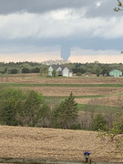
Pretty wild pictures and reports coming in, this is quite the system. Hope all are safe!
-
Busguy2010
- City Council
- Posts: 7327
- Joined: Sat Apr 09, 2011 7:32 pm
- Location: North Central Omaha