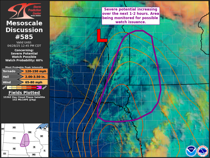
Mr.Nuke wrote: Fri Apr 25, 2025 3:55 am
Per KETV, Mike Flood is saying weather balloon launches from Valley will resume. They didn't give a timeline, but if it happens that would be a positive development.
Thats good! Hopefully they get that back up and running sometime in the near future.
Yeah we'll see. KETV posted a story late last night
As of Thursday, one weather balloon is expected to launch daily, and starting next week the operations will ramp up back to full force.
"Next week, they are assigning more meteorologists to the weather service office in Valley," Flood said. "We'll be back up to two weather balloons a day."
I got over 3 inches yesterday in Dundee, that first cell that spawned the tornado popped up right on top of us and the hailcore was damn near centered on my area for 45 minutes. I don't know if I've ever seen hail last that long.
Louie wrote: Fri Apr 25, 2025 1:46 pm
I got over 3 inches yesterday in Dundee, that first cell that spawned the tornado popped up right on top of us and the hailcore was damn near centered on my area for 45 minutes. I don't know if I've ever seen hail last that long.
Wow thats crazy. I hadn't seen that until last year's huge hail event. It did the same over Bellevue and Papillion for close to an hr. It wasn't the largest hail but bc there was so much of it, it did a ton of damage.
stormchaser wrote: Fri Apr 25, 2025 2:00 am
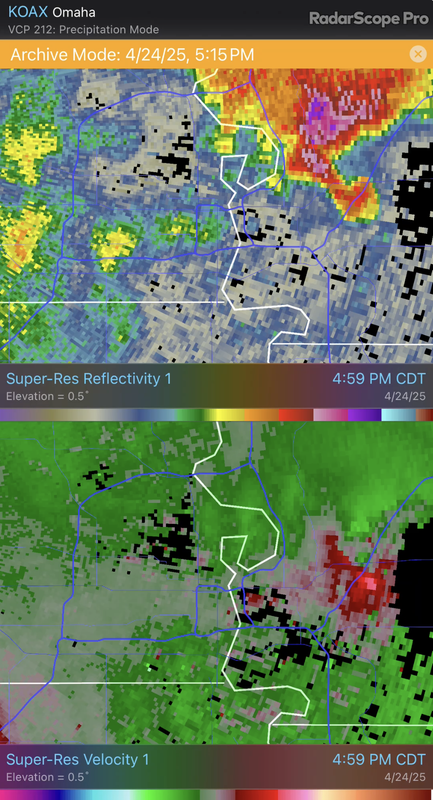
Apparently that was a brief tornado according to storm reports anyway. I’m not convinced it actually touched down though.
That was a weird radar presentation Thursday, the warned area was at the front of the storm, not much of a hook at all. I was assuming it was a QLCS, but a few minutes later KETV's mets mentioned a cell-merger. The last merger I can recall was Pawhuska/Bartlesville OK last year, and in that case the merger killed the tornado.
Tomorrow marks one year since the tornado outbreak hit the Lincoln/Omaha area. The Lincoln tornado crossed I-80 right in front of me. The Elkhorn tornado I was within a mile or so (though it was briefly obscured by rain from my perspective). I saw the "ghost train" from it and then eventually the large tornado appeared from the rain off to my north. I stopped chasing shortly thereafter to help with search and rescue with some homes that had been hit on the outskirts of Omaha.
My footage as the Lincoln tornado crossed the interstate in front of me and then roped out:
My footage of the Elkhorn tornado partially obscured by rain:
By far the craziest footage from that day that I've seen where a factory in Lincoln was hit:
stormchaser wrote: Fri Apr 25, 2025 2:00 am
Apparently that was a brief tornado according to storm reports anyway. I’m not convinced it actually touched down though.
That was a weird radar presentation Thursday, the warned area was at the front of the storm, not much of a hook at all. I was assuming it was a QLCS, but a few minutes later KETV's mets mentioned a cell-merger. The last merger I can recall was Pawhuska/Bartlesville OK last year, and in that case the merger killed the tornado.
Yep, it had some broad rotation as it moved up through parts of La Vista, etc but then it merged with a new storm moving up from the south just as it became tornado warned (in effect killing the tornado potential with the first storm). The second storm ended up having a pretty pronounced hook though on the eastern side of CB along I-80 - even though rotation tightened up for a little bit but ultimately the rotation was too broad and just too much cold air (which is a good thing, otherwise parts of Omaha/CB would have been in trouble).
Erik wrote: Tue Apr 22, 2025 2:53 am
Average last freeze is April 21st
Record earliest is March 5th
Curious on where you are seeing the March 5th from?
Me too. March 5th would be other worldly.
At Eppley I show the average date is 4/21, the earliest date was 3/29/1941. For the Omaha area which is a slightly different data set I show 3/21/1925 and the average date drops to 4/18. That data set also has 4/8 in 2010.
You are correct. Please pardon my brain damage, I don't know how I came up with March 5th.. I just started to look after the prompts and I got that Mandela feeling
Flood is taking a victory lap on this, but in the ketv story last night, an OWH article today and here he is acting like launches have already been occurring again. They have not.
"Moderate to strong instability, strong shear, and increasing forcing for ascent supports the potential for numerous rounds of severe thunderstorms. The wind profile supports supercells capable of all severe weather hazards including the potential for strong tornadoes."
Mr.Nuke wrote: Fri Apr 25, 2025 8:48 pm
7 p.m. will be interesting tonight...
Flood is taking a victory lap on this, but in the ketv story last night, an OWH article today and here he is acting like launches have already been occurring again. They have not.
Mr.Nuke wrote: Fri Apr 25, 2025 8:48 pm
7 p.m. will be interesting tonight...
Flood is taking a victory lap on this, but in the ketv story last night, an OWH article today and here he is acting like launches have already been occurring again. They have not.
lol, gotta love politicians…
SondeHub is picking up a signal on the ground so it looks like we will get a 0z launch tonight.
Mr.Nuke wrote: Sun Apr 27, 2025 2:27 pm
There remains a pretty big disconnect between the SPC's thinking about tomorrow and what model guidance has continued to indicate.
Yep, HRRR hasn’t been showing anything able to break the cap until you get well north of us into MN, etc. This could easily end up being a bust for many areas but I guess we’ll see.
Severe storms bring tornadoes, train derailment to Nebraska panhandle
Multiple tornadoes, a train derailment and large hail were reported Sunday across the Nebraska Panhandle.
There continues to be a fair amount of uncertainty with what will happen later today with these potential storms - more specifically, with the potential capping issues and whether or not storms can fire in our region or if things will hold off entirely or until at least east of here.
The HRRR has consistently shown to have a wedge of dry air pushing into our area that consequently pushes the dryline and area of potential storm development off to our east into Iowa by early afternoon. However, most other model guidance doesn't show this wedge of dry air pushing in as quickly as the HRRR and instead puts our area right along the dry line into late this afternoon. Consequently with the HRRR being an outlier, I'm disregarding it for now but watching trends to see which way things start to align.
What I currently expect to happen but may quickly change:
My current thought is initial storms will develop north of Omaha toward and perhaps north of Sioux City early this afternoon with the primary risk for tornadoes occurring in north central IA/southern MN this afternoon into this evening regardless of what happens here (right where the tip of the wedge of dry air ends up later this afternoon into this evening and closer to the low pressure).
I also believe supercells will develop somewhere close to Omaha but probably off to our east/southeast late this afternoon/early this evening. Exactly where or how far east of us will depend on potential capping and timing of storm development. I personally believe models are handling this capping poorly with most models keeping temps around the 700mb level (often roughly where you'll find a cap) well below 10c which typically is a breakable cap - especially given the amount of forcing/instability in place.
If Omaha gets hit, it'll likely be during the mid to late afternoon hours (IF the dryline doesn't push through early on like the HRRR is showing). If storms do form and fully overcome any capping issues, they will 100% pose a risk for tornados - some of which could be strong. Additionally there will be a risk of large/very large hail and damaging wind.
It'll be interesting to see what the 12z run of model guidance shows in about an hour. Regardless, please remain weather aware today as it has the potential of being a dangerous day depending on how things end up coming together.
Quick update, the 11z HRRR has finally started to trend away from the cap being too strong for storm development and produces several supercells just east/southeast of Omaha this afternoon. Will need to watch future model runs to see if this trend continues and if the HRRR continues to slow down with how quickly it pushes the wedge of dry air into our area. If it slows down enough, Omaha could very well be at risk (though just to clarify, odds are higher to our east/southeast still).
Padre wrote: Mon Apr 28, 2025 1:14 am
Severe storms bring tornadoes, train derailment to Nebraska panhandle
Multiple tornadoes, a train derailment and large hail were reported Sunday across the Nebraska Panhandle.
Luckily that was in very rural areas because at times, that tornado was really wide. It will be interesting to see what the NWS Survey teams find. The warnings probably stretched for 75-100 miles.
skinzfan23 wrote: Mon Apr 28, 2025 3:48 pm
Haven't seen him in a while:
Lol gotta love him.
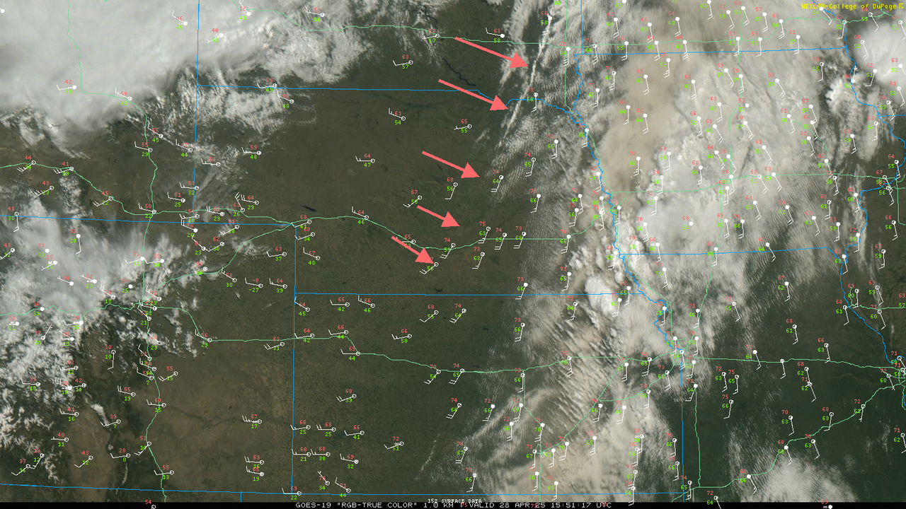
Pretty easy to see where the boundary is that's pushing in from the west on visible satellite. Just pushing through the Grand Island area now which is slower than initially depicted on the HRRR which trends things closer to the Omaha area potentially for later. I still think the main area will end up south and east of town based on the HRRR but hard to say until we see some cumulus fields start organizing in a few hours.
Nowhere near here, but for anybody else who spends time out in the sand hills, this happened yesterday.
It looked like my favored campsite may have taken a direct hit, or at least the mesocyclone passed practically directly over. I'm usually out there at this time of year, glad I wasn't this time.
stormchaser wrote: Mon Apr 28, 2025 4:46 pm
Based on model data, mesoanalysis, and visible satellite data, my current target is somewhere around Falls City, NE later this afternoon
That seems like a pretty good bet to me. OAX just launched a 17z balloon. Would've been nice to have had the 12z too.
stormchaser wrote: Mon Apr 28, 2025 4:46 pm
Based on model data, mesoanalysis, and visible satellite data, my current target is somewhere around Falls City, NE later this afternoon
That seems like a pretty good bet to me. OAX just launched a 17z balloon. Would've been nice to have had the 12z too.
Yeah, I'm torn though, the mesoanalysis and visible satellite are both pointing towards a target north/northwest of Omaha with a CU field forming along the boundary west of Omaha currently. Surface winds will be marginally better with the northern target IF something can get going...
Busguy2010 wrote: Mon Apr 28, 2025 5:14 pm
Nowhere near here, but for anybody else who spends time out in the sand hills, this happened yesterday.
It looked like my favored campsite may have taken a direct hit, or at least the mesocyclone passed practically directly over. I'm usually out there at this time of year, glad I wasn't this time.
Definitely a big tornado - it'll be interesting what they end up rating this one
It'll probably be an EF negative 2 since it likely hit nothing. But a tornado has to have a level of intensity to get that big and have that kind of reflectivity and velocity signature.
I get what you're poking at, but really... Compare that visual to any tornado that ever got rated EF-2, or 3, or 4. I mean, how can you not tell that's a fairly intense tornado?
Also the front is currently sweeping through the metro at the moment, so it'll be quite a bit more comfortable. Temperature is supposed to drop like a rock from here on.
Also we got actually hot today. I consider 89 hot for April at least. Not in the record territory of 94, but in the neighborhood. Definitely quite a warm day, out of my comfort zone at least, and by April standards. Just about 20 degrees above normal. Don't like that, so I'm glad it's cooling off so rapidly